Krasnoyarsk Reservoir
| Krasnoyarsk Reservoir | |||||||||
|---|---|---|---|---|---|---|---|---|---|
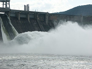
| Dam of the Krasnoyarsk hydropower plant | |||||||||
|
|||||||||
|
|
|||||||||
| Coordinates | 55 ° 53 '0 " N , 92 ° 15' 0" E | ||||||||
| Data on the structure | |||||||||
| Lock type: | Gravity dam | ||||||||
| Construction time: | 1961-1968 | ||||||||
| Height above foundation level : | 124 m / 119 m | ||||||||
| Crown length: | 1,065 or 1,072 m | ||||||||
| Crown width: | 24 m | ||||||||
| Base width: | 140 m | ||||||||
| Power plant output: | 6th 000 MW | ||||||||
| Data on the reservoir | |||||||||
| Altitude (at congestion destination ) | 243 m | ||||||||
| Water surface | 2,130 km² | ||||||||
| Reservoir length | approx. 400 km | ||||||||
| Reservoir width | up to 15 km | ||||||||
| Storage space | 73,300 million m³ | ||||||||
| Catchment area | 289,000 km² | ||||||||
| Design flood : | 14,600 m³ / s | ||||||||
| Particularities: | |||||||||
|
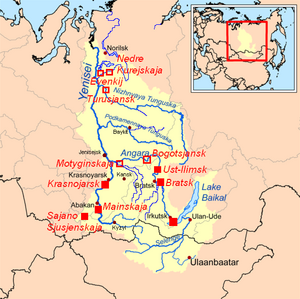
Power plants in the Yenisei catchment area: _ Existing, _ Planned |
|||||||||
| Krasnoyarsk boat lift | |||||||||
The Krasnoyarsk Reservoir ( Russian: Красноярское водохранилище / Krasnojarskoje vodochranilishche ) is a 2130 km² reservoir on the Yenisei in the Krasnoyarsk region and the Republic of Khakassia in Siberia .
The lake is a reservoir dammed, dealing with its 6,000- megawatt - power plant in Divnogorsk located about 30 km west of Krasnoyarsk . It is shown on the ten- ruble note .
The reservoir has been used since 1967 to generate electricity for the industrial development of the region and also for flood protection .
geography
location
The reservoir is located in the South Siberian Mountains between the river plains of the Yenisei in the north, which crosses below the dam to the West Siberian lowlands , the western foothills of the East Sayan in the east, the northern foothills of the West Sayan in the south and the eastern foothills of the Kuznetsk Alatau in the west.
Tributaries
The most important tributaries of the Krasnoyarsk reservoir are the Yenisei and the Abakan , both of which flow into the southern part of the lake between the neighboring cities of Abakan in the west and Minussinsk in the east. A little further north, the Tuba River flows in from the east. In addition, there are several hundred smaller flowing waters along the elongated lake .
Dimensions
The Krasnoyarsk Reservoir is one of the largest on earth . It stretches between its barrier structure at Divnogorsk in the Krasnoyarsk region to Abakan , the capital of Khakassia , over a length of 388 km. With its width of up to 15 km it reaches an area of 2130 km². On average it is 34.4 m deep; near the dam, its depth reaches 101 m, almost its height. The storage space is 73,300 million m³. The height of the congestion destination is usually 243 m .
Buildings
From 1956, the actual construction of the dam was preceded by preparatory work in which personnel were recruited and equipment such as vehicles and machines were procured. Temporary workers' quarters and warehouses as well as roads and power lines were also built. At times up to 20,000 workers began the earthworks in 1959, and in 1961 with the concreting of the dam. The power plant went into operation in 1967, and in 1970 the lake reached its storage destination .
dam
For the gravity dam of dam 4,715,000 cubic meters of concrete were used.
power plant
The power plant near Divnogorsk was put into operation on the 50th anniversary of the October Revolution on November 3-4, 1967. Two turbines were installed in its 360 m long and 31 m wide machine hall. Three more followed in 1968, four more in 1969, one in 1970 and the last two in 1971. In its final stage with 12 turbines, the power plant has an output of 6,000 megawatts , making it one of the largest on earth . In terms of peak output, it ranks second in Russia after the Sayano-Shushensk reservoir , and even in first place in terms of annual energy production. Around 70% of the electricity generated is used by the KrAZ (Krasnoyarsky Aluminievyy Zavod) aluminum plant , the second largest in the world.
Boat lift
The Krasnoyarsk boat lift (Красноярский судоподъемник) is the only boat lift in Russia and until the completion of the one on the Three Gorges Dam, the largest in the world. Ships with a load capacity of up to 2,000 t can be transported.
The decision was made to use a boat lift at the Krasnoyarsk reservoir because the dam is located between two rocks, which would have made it difficult to widen a lock chamber. It was built in the form of an approximately 1.5 km long cog railway , because this enables operation even with the unusually large water level differences of up to 13 m on the upper course and about 6.5 m on the lower course.
In operation, a self-propelled trough with internal dimensions of 90 by 12 m and a total weight of 8,100 t, which holds the ships to be transported, moves on rails with an electro-hydraulic drive. The trough runs on 156 wheels with a diameter of 1.05 m, which are driven by hydraulic motors and grip into the racks mounted on the side of the rails. The drive power is 14,400 kW. The rails have the profile of a bridge crane, a track width of 9,000 mm and are mounted on a small concrete base. Power is supplied by three pantographs via a three-phase overhead line that runs along the entire route.
The railroad leads from the lower reaches first over rocks. After that, a cut in the terrain is spanned with a pier bridge. Shortly afterwards, a path crosses the rails by means of two simple half bridges that can be folded away if necessary. After 1190 m the railroad reaches its highest point. Here is a turntable with a diameter of 106 m, on which the rail vehicle is pivoted through 142 ° in order to continue its journey on a sloping, 306 m long stretch to the upper reaches of the river.
Approximately halfway up the turntable there is a service track where there is also a gantry crane. There the vehicle stands when not in use or for the winter. Just opposite downhill is a short service track with a small mobile service platform.
All sections of the route - including the one on the turntable - have a gradient of 10%. The vehicle compensates for this inclination with its sloping structure. The construction of the turntable differs from the usual normal form, in which the two support points of the bridge girder move on a circular, horizontal turntable running ring all around and the turntable can rotate 360 °. At the turntable at the Krasnoyarsk ship lift there are two separate, opposite turntable rims in the form of opposite circular arcs with a common center and center angles of slightly less than 180 ° each. The two treads each run horizontally, but are built on a slope in such a way that they are at different heights. Accordingly, one tread serves as a support for the higher end of the inclined bridge girder, the other for the lower end. Due to its construction, the turntable cannot rotate completely through 360 °, but only through a little less than 180 °; it is therefore a segment turntable .
After six years of construction, the ship lift went into trial operation: on September 22, 1976, the GT-8 (ГТ-8), the first ship to cross over within 93 minutes. After the end of the trial operation and after approval by the state commission, the ship lift was officially opened in 1982. During the Soviet era, it was in operation throughout the ice-free period. The previous peak load was reached in 1991 with 611 ships. Then inland shipping fell sharply and since 1998 the facility has only been in operation from September 3rd to October 3rd. In 2000 only 78 ships were transported. Shortly before the winter break, mainly agricultural products are shipped from the south of the region and Khakassia to the northern areas, for example to Norilsk . For the repair of the Sajano-Schuschensker power plant , which was badly damaged in an accident in 2009 , 6.77 m turbine runners were transported with the ship lift. Time and again, government grants are granted for the most necessary maintenance work. In recent years, projects to revitalize the entire inland navigation sector have also been started. Up until 2010, these attempts had not yet been reflected in the ship lift.
Consequences of the dam construction
When the lake was dammed between 1967 and 1970, 120,000 hectares of agricultural land and 13,750 houses in numerous towns were flooded.
The climate in the region has changed due to the reservoir . It has become more humid and rainy and there is now more fog . The Yenisei, which was ice-free for only 196 days a year before the dam was built, is now 300 to 400 km below the dam all year round. Before the construction, only 20 km of ice-free river was expected. However, the reservoir itself freezes over in winter.
The seasonal fluctuations in the water flow of the Yenisei below the dam and the associated flood risks for Krasnoyarsk and the formerly closed city of Krasnoyarsk-26 have been extremely reduced. In the long-term average, before the dam was built, the monthly water volume related to one twelfth of the total annual water volume fluctuated between 18% (in March) and 306% (in June), afterwards only between 73% (November) and 125% (July). The total annual water volume has decreased by more than 5%.
See also
- List of the largest dams on earth
- List of the largest reservoirs on earth
- List of the largest hydroelectric plants in the world
- List of dams in the world
Web links
- The Yenisei River
- Trip to the Dam
- Pictures of the ship lift - passage of a container ship (ru)
- Construction of the dam by LHP
Individual evidence
- ↑ a b Article Krasnoyarsk Reservoir in the Great Soviet Encyclopedia (BSE) , 3rd edition 1969–1978 (Russian)
- ↑ Construction phases ( Memento of the original from July 21, 2015 in the Internet Archive ) Info: The archive link was inserted automatically and has not yet been checked. Please check the original and archive link according to the instructions and then remove this notice. Operator's website (Russian)
- ↑ NA Dvorzhnyak and NN Sergeev: lift Krasnoyarsk ship , Power Technology and Engineering (formerly Hydro Technical Construction), Springer, New York, ISSN 1570-145X (Print), ISSN 1570 to 1468 (online), Vol 19, No. 10 /.. October 1985, pp. 546-551
- ↑ Schönknecht / Gewiese: On rivers and canals, 1988. S. 191/193. Shipping in Russia
- ↑ a b Судоподъемник Красноярской ГЭС. Фото , January 17, 2008, gazeta.lv
- ↑ Красноярская ГЭС // Колесов, А. Н. По Енисею / А. Н. Колесов. - Красноярск: Красноярское книжное издательство, 1990. - С. 47-50, in: Archived copy ( Memento of the original from March 5, 2016 in the Internet Archive ) Info: The archive link was inserted automatically and has not yet been checked. Please check the original and archive link according to the instructions and then remove this notice.
- ↑ Юрий Чувашев: Уникальное сооружение никому не нужно , August 23, 2001, www.ng.ru
- ↑ Сроки работы основных шлюзов на внутренних водных путях в навигации 2010-2012 г.г. ( Memento of the original from April 4, 2010 in the Internet Archive ) Info: The archive link was inserted automatically and has not yet been checked. Please check the original and archive link according to the instructions and then remove this notice. (Timeline of the main gateways on the inland waterways for shipping, 2010-2012), volzhskoe.gbu.ru
- ↑ Красноярский судоподъемник готовится к открытию навигации ( Memento of the original from April 9, 2012 in the Internet Archive ) Info: The archive link was inserted automatically and has not yet been checked. Please check the original and archive link according to the instructions and then remove this notice. , August 13, 2001, yarsk.ru
- ↑ Press office of ОАО "Енисейское речное пароходство" ( JSC "Yenisei Shipping Company" ): ЕРП откроет навигацию на Красноярском , ru
- ↑ На Саяно-Шушенской ГЭС завершен демонтаж гидроагрегата №2 , April 16, 2010, minenergo.gov.ru
- ↑ Yenisei at the Diwnogorsk gauge - hydrographic data from R-ArcticNET


