Tuba (river)
|
Tuba Туба́, Туба |
||
|
Flooding of the tuba in the area where it flows into the reservoir |
||
| Data | ||
| Water code | RU : 17010300312116100015313 | |
| location | Krasnoyarsk Region ( Russia ) | |
| River system | Yenisei | |
| Drain over | Yenisei → Arctic Ocean | |
| Confluence of |
Kasyr and Amyl 53 ° 46 '52 " N , 92 ° 53' 30" E |
|
| Source height | 292 m | |
| muzzle |
Krasnoyarsk Reservoir Coordinates: 53 ° 57 ′ 45 " N , 91 ° 39 ′ 0" E 53 ° 57 ′ 45 " N , 91 ° 39 ′ 0" E |
|
| Mouth height | 243 m | |
| Height difference | 49 m | |
| Bottom slope | 0.41 ‰ | |
| length | 119 km (507 km with source river Kasyr ) | |
| Catchment area | 36,900 km² | |
| Discharge at the Bugurtak A Eo gauge : 31,800 km² Location: 94 km above the estuary |
MNQ 1911/1999 MQ 1911/1999 Mq 1911/1999 MHQ 1911/1999 |
100 m³ / s 746 m³ / s 23.5 l / (s km²) 2543 m³ / s |
| Discharge at the Ilinsk A Eo gauge : 36,500 km² Location: 46 km above the estuary |
MNQ 1954/1963 MQ 1954/1963 Mq 1954/1963 MHQ 1954/1963 |
107 m³ / s 792 m³ / s 21.7 l / (s km²) 2628 m³ / s |
| Small towns | Kuragino | |
| Navigable | from May to October on 99 km, from Kuragino | |
|
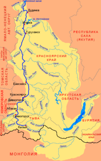
Location of the tuba in the catchment area of the Yenisei |
||
The Tuba ( Russian Туба ) is a river in the Krasnoyarsk Territory in Russia and is a right tributary of the Yenisei .
The river is 119 km long, from the source of the Kasyr even 507 km, of which it is navigable for 99 km. The catchment area of the tuba is 36,900 km². In this area there are over 1000 lakes with a total area of 91 km². The tuba is created by the confluence of the Kasyr and Amyl rivers around 20 km southeast of Kuragino . Several small streams from the Eastern Sayan flow into it . It flows heavily branched and flows into the Tubinsky Bay of the Krasnoyarsk Reservoir .
The average amount of water is 771 m³ / s. The months with the most water are due to the snowmelt in May and June with 2,269 m³ / s and 2,482 m³ / s respectively. In March the tuba has the least amount of water with 104 m³ / s. The tuba is frozen from late October, early December to late April and early May. Two road bridges cross the river (near the village of Gorodok and southwest of Kuragino) and a railway bridge south of Kuragino.
Individual evidence
- ^ Soviet General Staff Map 1: 100,000 sheets N-46-078
- ↑ Soviet General Staff Map 1: 100,000 sheets N-46-076
- ↑ a b Tuba in the State Water Register of the Russian Federation (Russian)
- ↑ a b Article tuba in the Great Soviet Encyclopedia (BSE) , 3rd edition 1969–1978 (Russian)
- ↑ Tuba at the Bugurtak gauge - hydrographic data from R-ArcticNET
- ↑ Tuba at the Ilinsk gauge - hydrographic data from R-ArcticNET
- ↑ Unesco - measuring point near Burgutak ( Memento of the original from November 25th, 2009 in the Internet Archive ) Info: The archive link was inserted automatically and has not yet been checked. Please check the original and archive link according to the instructions and then remove this notice.

