Tuvinian basin
Coordinates: 53 ° 42 ′ 0 ″ N , 91 ° 41 ′ 0 ″ E
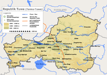
The Tuvinian Basin ( Russian Туви́нская котлови́на ) is a basin landscape in the south of Siberia .
The Tuvinian Basin forms a large part of the territory of the Russian Republic of Tuva . The basin is framed by the mountain ranges of the South Siberian Mountains . In the north lies the Western Sayan , in the west the Altai with the Shapshal ridge and in the south the mountain ranges of the Tannu-ola Mountains . The Tuvinian Basin has a spatial extension of 400 km in west-east direction and between 25 and 70 km in north-south direction. The height varies between 600 and 900 m . The basin has the relief of a plain interspersed with hills, with thresholds in some areas . The upper reaches of the Yenisei (also Ulug-Chem ) and its left source river, the Little Yenisei , flow through the eastern part of the basin. The Yenisei then breaks through the Western Sayan mountain range to the north. The western part of the basin is drained by its left tributary Chemtschik . The low Adar-Dasch ridge separates the two sub-basins - the Chemtschik basin in the west and the Ulug-Chem basin in the east. Pasture farming and sheep breeding as well as cereal cultivation ( wheat , barley and millet ) are operated. In Tuvan pool Nearby cities are Kyzyl , Shagonar , Chadan and Ak-Dovurak . There are hard coal deposits in the Ulug-Chem basin .
Web links
Individual evidence
- ↑ a b c d Article Tuvinian Basin in the Great Soviet Encyclopedia (BSE) , 3rd edition 1969–1978 (Russian)


