Turuchan
|
Turukhan Турухан |
||
|
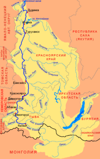
Location of the Turuchan (Турухан) in the catchment area of the Yenisei |
||
| Data | ||
| Water code | RU : 17010800212116100097346 | |
| location | Krasnoyarsk Region ( Russia ) | |
| River system | Yenisei | |
| Drain over | Yenisei → Arctic Ocean | |
| source |
West Siberian Lowlands 67 ° 13 ′ 55 ″ N , 85 ° 51 ′ 36 ″ E |
|
| Source height | approx. 135 m | |
| muzzle |
Yenisei coordinates: 65 ° 55 ′ 47 " N , 87 ° 41 ′ 52" E 65 ° 55 ′ 47 " N , 87 ° 41 ′ 52" E |
|
| Mouth height | 5 m | |
| Height difference | approx. 130 m | |
| Bottom slope | approx. 0.2 ‰ | |
| length | 639 km | |
| Catchment area | 35,800 km² | |
| Discharge at the Janow Stan A Eo gauge : 10,100 km² Location: 277 km above the estuary |
MQ 1941/1999 Mq 1941/1999 |
107 m³ / s 10.6 l / (s km²) |
| Left tributaries | Makovskaya | |
| Right tributaries | Ussomchik , Great Bludnaja , Upper Baicha , Lower Baicha | |
| Navigable | 288 km (from Janow Stan) | |
The Turuchan ( Russian Турухан ) is a 639 km long left tributary of the Yenisei in Western Siberia ( Russia , Asia ).
course
The Turuchan flows away from a small lake at about 135 m on the northeastern edge of the West Siberian lowlands . It initially flows through several other small lakes in a north-westerly direction, such as Lake Turukhanskoe, then turns sharply to the south and continues through the lowlands in mainly southern to eastern directions until it flows into the left tributary of the Bolshoi Schar of the Yenisei. The mouth is located almost 20 kilometers northwest of the settlement named after the river Turukhansk , which, however, lies on the far bank of the Yenisei directly at the mouth of the Lower Tunguska .
The most important tributaries of the Turuchan are from the right Ussomtschik , Great Bludnaja (Bolshaya Bludnaja), Upper Baicha (Verkhnyaya Baicha) and Lower Baicha (Nizhnyaya Baicha) and from the left the Makovskaya .
The Turuchan flows through the northwest of the Krasnoyarsk Territory along its entire length .
Hydrography
The catchment area of the Turuchan covers 38,500 km². Near the mouth, the river is almost 400 meters wide and over three meters deep; the flow velocity here is 0.3 m / s.
The mean water flow near the mouth is 371 m³ / s, at the Janow Stan settlement ( ⊙ ) on the middle reaches, 277 kilometers above the mouth, 108 m³ / s with a minimum of 4.9 m³ / s in March and a maximum of 727 m³ / s in June.
The Turuchan freezes over between October and the end of May until the first half of June.
Economy and Infrastructure
The Turuchan is navigable for 288 kilometers from the Janow Stan settlement.
The territory through which it flows is very sparsely populated. Besides the aforementioned Janow Stan, only the two villages Farkowo and Staroturuchansk on the lower reaches exist on the river. There is therefore no infrastructure whatsoever.
At the end of the 1940s, construction began on the Arctic Circle Railway , which was to cross the river near Janow Stan and follow from there along the left bank in an easterly direction for about 100 kilometers to the now abandoned settlement Kostjor. With the exception of individual objects such as the Turuchan Bridge near Janow Stan, construction of this section of the route was relatively far advanced at the time of the construction stop in 1953.
Individual evidence
- ↑ a b Turuchan in the State Water Directory of the Russian Federation (Russian)
- ↑ a b c Article Turuchan in the Great Soviet Encyclopedia (BSE) , 3rd edition 1969–1978 (Russian)
- ↑ a b Turuchan at the Janow Stan gauge - hydrographic data at R-ArcticNET
- ↑ List of Inland Waterways of the Russian Federation (confirmed by Order No. 1800 of the Government of the Russian Federation of December 19, 2002)
Web links
- Article Turuchan in the Great Soviet Encyclopedia (BSE) , 3rd edition 1969–1978 (Russian)
