Kan (Yenisei)
|
Kan Кан |
||
| Data | ||
| Water code | RU : 17010300412116100021269 | |
| location | Krasnoyarsk Region ( Russia ) | |
| River system | Yenisei | |
| Drain over | Yenisei → Arctic Ocean | |
| source |
Eastern Sayan 54 ° 14 ′ 26 " N , 95 ° 35 ′ 4" E |
|
| muzzle | in the Yenisei near Ust-Kan , 70 km northeast of Krasnoyarsk Coordinates: 56 ° 30 '43 " N , 93 ° 47' 28" E 56 ° 30 '43 " N , 93 ° 47' 28" E
|
|
| length | 629 km | |
| Catchment area | 36,900 km² | |
| Discharge at the Kan-Okler A Eo gauge : 4180 km² Location: 482 km above the mouth |
MQ 1973/1993 Mq 1973/1993 |
67 m³ / s 16 l / (s km²) |
| Discharge at the Irebeiskoje A Eo gauge : 8710 km² Location: 355 km above the mouth |
MQ 1937/1993 Mq 1937/1993 |
97 m³ / s 11.1 l / (s km²) |
| Discharge at the Kansk A Eo gauge : 23,000 km². Location: 230 km above the mouth |
MQ 1936/1999 Mq 1936/1999 |
243 m³ / s 10.6 l / (s km²) |
| Discharge at the Podporog A Eo gauge : 36,800 km² Location: 17 km above the estuary |
MQ 1938/1989 Mq 1938/1989 |
293 m³ / s 8 l / (s km²) |
| Left tributaries | Rybnaya , Bolshaya Urja , Ansha | |
| Right tributaries | Kurysch , Agul , Ilanka | |
| Big cities | Kansk | |
| Medium-sized cities | Zelenogorsk | |
|
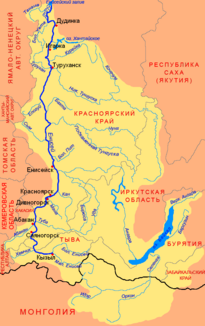
Location of the Kan (Кан) in the catchment area of the Yenisei |
||
The Kan ( Russian Кан ) is a 629 km long, southeast or right tributary of the Yenisei in Russia ( Asia ).
The river has its source in the southern Siberian East Sayan and flows from there in a northerly direction to Kansk and then in a westerly direction to flow northeast of Krasnoyarsk near Ust-Kan into the Yenisei . 17 km before the mouth, the mean discharge of the Kan is 293 m³ / s. In March the monthly mean is 39 m³ / s, while in May the mean is 811 m³ / s.
literature
- A. Gorkin and others: Geografija Rossii: Enziklopeditscheski slowar . Bolschaja Rossijskaja enziklopedija, Moscow 1997, ISBN 5-85270-276-5 , p. 236. (Russian)
Individual evidence
- ↑ a b Kan in the State Water Register of the Russian Federation (Russian)
- ↑ a b Article Kan in the Great Soviet Encyclopedia (BSE) , 3rd edition 1969–1978 (Russian)
- ↑ Kan at the Kan-Okler gauge - hydrographic data at R-ArcticNET
- ↑ Kan at the Irebeiskoje gauge - hydrographic data from R-ArcticNET
- ↑ Kan at the Kansk gauge - hydrographic data from R-ArcticNET
- ↑ a b Kan at the Podporog gauge - hydrographic data at R-ArcticNET

