Mana (Yenisei)
|
Mana Мана |
||
|
Mana near the settlement of Ust-Mana |
||
| Data | ||
| Water code | RU : 17010300512116100020100 | |
| location | Krasnoyarsk Region ( Russia ) | |
| River system | Yenisei | |
| Drain over | Yenisei → Arctic Ocean | |
| source | in Eastern Sayan 54 ° 26 ′ 40 ″ N , 94 ° 44 ′ 59 ″ E |
|
| muzzle | near Ust-Mana ( Divnogorsk ) in the Yenisei Coordinates: 55 ° 56 '46 " N , 92 ° 28' 44" E 55 ° 56 '46 " N , 92 ° 28' 44" E
|
|
| length | 475 km | |
| Catchment area | 9320 km² | |
| Discharge at the Manski A Eo gauge : 9260 km² Location: 12 km above the mouth |
MQ 1936/1999 Mq 1936/1999 |
100 m³ / s 10.8 l / (s km²) |
|
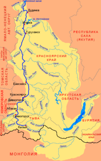
Location of mana in the catchment area of the Yenisei |
||
The Mana ( Russian Мана ), in the upper reaches Prawaja Mana ( Правая Мана ; called right Mana ), is an approximately 475 km long, southeast and orographically right tributary of the Yenisei in the Krasnoyarsk region in Siberia , Russia ( Asia ).
course
The mana springs are in the Eastern Sayan . The river runs in a predominantly north-westerly direction through the north-west foothills of the mountains. From the village of Mana to the confluence with the Yenisei there are only seven villages or hamlets. The Mana flows about 11.5 km (as the crow flies ) east-northeast below the dam of the Krasnoyarsk Reservoir at Ust-Mana (which means mouth of the Mana ), an eastern settlement of Divnogorsk , into the Yenisei flowing to the Arctic Ocean .
Catchment area and runoff
The catchment area of the Mana is 9,320 km². The mean monthly runoff amounts to 32.7 m³ / s in the month of March with the least water and 230 m³ / s in the month of May with the most water. The mana is completely free-flowing, there is no weir and no barrage here.
traffic
The village of Mana can be reached once a day by bus or train from Krasnoyarsk, both connections being branch lines, i.e. not running hundreds of kilometers along the river. The places Narva, Uman and Beretj have daily bus connections to Krasnoyarsk.
There is no commercial shipping on the Mana, there are only a few 4-seater motorboats operated by the locals and from 2015 one or two motorized rafts for 10 to 20 people from a tourist company from Narva or Uman and almost every day also mainly from Beretj, but occasionally too from Narva (240 km river to Ust-Mana) and Uman (120 km river to Ust-Mana).
The Mana is popular for rafting . From the village of Mana, kayaks, canoes and rafts travel around 330 km as a river hiking route through the mountain taiga of the Sajan. The main route runs from the village of Beretj about 90 km before the confluence with the Yenisei and then on this for another 26 km to the metropolis of Krasnoyarsk. The most frequent use takes place in the week before and until the Krasnoyarsk city festival, which takes place every year on June 12th.
Web links
- Peking Express - the RTL adventure show , 5th stage, on russlandjournal.de


