Jelogui
|
Jelogui Елогуй |
||
|
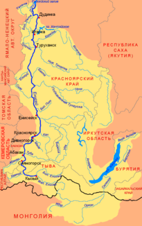
Location of the Jelogui (Елогуй) in the catchment area of the Yenisei |
||
| Data | ||
| Water code | RU : 17010600112116100057194 | |
| location | Krasnoyarsk Region ( Russia ) | |
| River system | Yenisei | |
| Drain over | Yenisei → Arctic Ocean | |
| Headwaters |
West Siberian Lowlands 61 ° 58 ′ 42 ″ N , 85 ° 11 ′ 12 ″ E |
|
| Source height | approx. 121 m | |
| muzzle |
Yenisei near Verkhneimbatskoje Coordinates: 63 ° 12 '52 " N , 87 ° 45' 28" E 63 ° 12 '52 " N , 87 ° 45' 28" E |
|
| Mouth height | 17 m | |
| Height difference | approx. 104 m | |
| Bottom slope | approx. 0.22 ‰ | |
| length | 464 km | |
| Catchment area | 25,100 km² | |
| Discharge at the Jelogui A Eo gauge : 16,300 km² Location: 168 km above the mouth |
MQ 1960/1999 Mq 1960/1999 |
166 m³ / s 10.2 l / (s km²) |
| Left tributaries | Kellog | |
| Right tributaries | Tankses, Tyna, Bolshaya Sigowaja, Dalimtsches | |
| Communities | Kellog | |
| Navigable | 170 km | |
The Jelogui ( Russian Елогуй ) is a 464 km long left tributary of the Yenisei on the eastern edge of the West Siberian lowlands in Russia .
course
The Jelogui arises at a height of about 121 m in the western central part of the Krasnoyarsk region from the short source rivers Rechter Jelogui (Prawy Jelogui) and Linker Jelogui (Lewy Jelogui). These source rivers, which are only 20 km long, have their origin in the swampy area of the watershed to the Ob catchment area at an altitude of about 180 m . Source rivers and the upper Jelogui flow first to the west, before this soon turns south, then east and finally north. The Jelogui then mostly flows strongly meandering in increasingly north-easterly directions through strongly swampy taiga landscape . About 30 km above the confluence with the Yenisei, the much smaller tributary Krivoy Jelogui ("Krummer Jelogui") divides to the right. The main arm flows into the Yenisei about 12 km below the village of Verkhneimbatskoje on the far right bank of the Yenisei at a height of 17 m , the Krivoy Jelogui opposite the Verkhneimbatskoje into a left arm of the Yenisei.
The major tributaries of the Jelogui are the Kellog from the left and the Tanks, Tyna, Bolschaja Sigowaja and Dalimtsches from the right, the latter flowing into the Krivoy Jelogui estuary.
Over its entire length of Jelogui flows through the southwestern part of the Rajons Turuchansk the Krasnoyarsk Territory.
A 747,600 hectare taiga area, through which the upper reaches of the Jelogui and its tributaries Tanks and Tyna flow, has been under nature protection since 1987 as Jeloguiski sakasnik .
Hydrography
The catchment area of the Jelogui covers 25,100 km². Near the mouth of the river, the river is about 150 m wide and over 1 m deep; the flow velocity here is 0.6 m / s.
The Jelogui freezes from late October to May, followed by strong spring floods and a relatively long-lasting summer flood. The water flow in the central reaches of the Kellog settlement , 168 kilometers above the estuary, is an annual average of 166 m³ / s with a minimum of 52.6 m³ / s in March and a maximum of 550 m³ / s in May.
Infrastructure and population
The river is navigable for 170 km from the Kellog settlement, which is also the only place on the river. Otherwise the area through which it flows is practically unpopulated and there is no transport infrastructure.
The place Kellog is one of the main settlement points of the Keten , a small indigenous people of Siberia . Of the almost 300 residents, over 200 are Keten, which is a seventh of the total. In 2003 the village was one of the last in the Krasnoyarsk Territory to receive (satellite) telephone connections. In addition, about 25 Selkupen and Evenks live in the village . Other small factories that used to exist on the river (Jelogui and Sigowaja below Kellog and Dobaka and Isseltsches above) are now uninhabited.
Individual evidence
- ↑ a b Jelogui in the State Water Register of the Russian Federation (Russian)
- ↑ a b Article Jelogui in the Great Soviet Encyclopedia (BSE) , 3rd edition 1969–1978 (Russian)
- ↑ a b Jelogui at the Jelogui gauge (Kellog) - hydrographic data at R-ArcticNET
- ↑ Jeloguiski sakasnik in the information and information system Specially Protected Natural Areas of Russia of the Center for Nature Conservation (Russian)
- ↑ List of inland waterways of the Russian Federation (confirmed by Order No. 1800 of the Government of the Russian Federation of December 19, 2002), on skitalets.ru (Russian)
- ↑ Keten - Yenisei apart from the Yenisei. Archived from the original on January 5, 2011 ; Retrieved July 18, 2016 . , on 1september.ru (Russian, photos)
- ↑ Konstantin Klokow: Traditional economy of the peoples of the north and protected territories (on the problem of creating a central Siberian biosphere reserve). Archived from the original on June 8, 2003 ; Retrieved July 18, 2016 . , at the State University of Saint Petersburg , on rangifer.org (Russian)
