Tuul
|
Tuul Туул гол |
||
|
Location of the Tuul in the catchment area of the Selenga |
||
| Data | ||
| location | Töw , Ulaanbaatar , Bulgan , Selenge ( Mongolia ) | |
| River system | Yenisei | |
| Drain over | Orkhon → Selenga → Angara → Yenisei → Arctic Ocean | |
| origin | in the Chentii Mountains near Lake Hagiin-Har Nuur 48 ° 30 ′ 39 ″ N , 108 ° 13 ′ 18 ″ E |
|
| Source height | approx. 1850 m | |
| muzzle | at Orchontuul in the Orchon coordinates: 48 ° 56 '54 " N , 104 ° 47' 55" E 48 ° 56 '54 " N , 104 ° 47' 55" E |
|
| Mouth height | approx. 780 m | |
| Height difference | approx. 1070 m | |
| Bottom slope | approx. 1.3 ‰ | |
| length | approx. 819 km | |
| Catchment area | approx. 49,840 km² | |
| Discharge at gauge Ulaanbaatar A Eo : 6296 km² |
NNQ MQ 1946-1991 Mq 1946-1991 HHQ |
0 l / s 26.57 m³ / s 4.2 l / (s km²) 627 m³ / s |
| Left tributaries | Charuchyn | |
| Right tributaries | Chagin, Tereldschi | |
| Big cities | Ulaanbaatar | |
|
Tuul in the Gorchi-Tereldsch National Park |
||
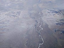
The (or the) Tuul ( Mongolian Туул гол , Tuul gol , in older sources also Tola ) is an approximately 819 km long tributary of the Orkhon in central and northern Mongolia ( Asia ) and at the same time the third longest river in Mongolia. Its catchment area covers around 49,840 km².
course
The source streams of the Tuul, including the Namin-Gol, arise within the Töw-Aimag in the Chentii Mountains near Lake Hagiin-Har . In the local Gorchi-Tereldsch National Park they flow through wide valleys formed by Ice Age glaciers. Their confluence is at an altitude of about 1850 m .
After leaving the mountainous country, the Tuul, which initially flows south-west and which is divided into several arms and strongly meandering , crosses the southern outskirts of the Mongolian capital Ulaanbaatar . Later it touches the southern edge of the Chustain Nuruu National Park and runs through the Töw-Aimag again. A little below it, it turns mainly to the northwest and reaches the border with the Bulgan-Aimag , which from now on follows its northward course.
Finally, the Tuul opens in Selenge Province near Orchontuul to approximately 780 m height in the Orchon that on the Selenga (Selenge) in the Baikal flows.
Ice drift, fauna and flora
The Tuul is mostly covered by ice from November to April . It is home to some endangered species of sturgeon . The area around the river is characterized by willow and birch forests.
environment
The lower reaches of the Tuul are heavily polluted, especially below the central wastewater treatment plant in Ulaanbaatar. The heavily sedimenting river is also polluted by minerals that are washed into the Töw-Aimag by mining activities in the Zaamar Sum . The increasing settlement pressure along the river also contributes to the pollution.
Equestrian statue of Genghis Khan
Somewhat upstream from Ulaanbaatar, around 54 km east-southeast of the city, an equestrian statue of Genghis Khan has been standing a short distance from the southern bank since 2008 , which, with a total structure height of around 40 m, is currently the highest equestrian statue in the world (status: 2011).
Web links
- The Mongolian Treasure , Berliner Zeitung (April 26, 2007) about the gold diggers on the Tuul
- UNESCO report ( Memento of September 28, 2007 in the Internet Archive ) on water use in Mongolia (English)
Individual evidence
- ↑ a b Overview of Mongolian waters (Mongolian) ( Memento from June 11, 2012 in the Internet Archive )
- ↑ a b N. Buyankhishig, G. Udvaltsetseg: Tuul-Terelj-Basin of Mongolia ( MS PowerPoint ; 6.8 MB)
- ↑ Average discharge in Ulaanbaatar after emerging from the mountains, water flow only slightly increasing in the further course (in parts also decreasing), data from N. Buyankhishig, G. Udvaltsetseg: Tuul-Terelj-Basin of Mongolia ( MS PowerPoint ; 6.8 MB)
- ↑ Werner Elstner: Mongolei , p. 16. Berlin 1993
- ↑ Genghis Khan Equestrian Statue. In: Atlas Obscura. Retrieved May 31, 2011 .


