Pamir (mountains)
| Pamir | |
|---|---|
|
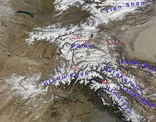
Map of the Pamir Mountains |
|
|
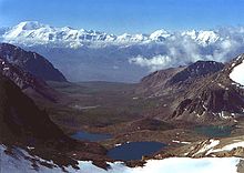
Typical Pamir landscape |
|
| Highest peak | Kongur ( 7649 m ) |
| location | Tajikistan , Xinjiang ( PRC ), Afghanistan , Kyrgyzstan |
| Coordinates | 38 ° 38 ′ N , 75 ° 20 ′ E |
| surface | 120,000 km² |
The Pamir is a high mountain range in Central Asia , which is considered to be the roof of the world . It has an area of about 120,000 km², of which about 12,500 km² are glaciated.
Origin of name
The origin of the name is unclear. “Pamir” is derived from a Turkish word meaning “cold steppe pasture”. In the 19th century the name was linked to Indian mythology and understood as an abbreviation of Sanskrit upa meru , "beyond the (holy) mountain Meru "; correspondingly shortened from Sanskrit upa mery , "the land behind the river bed". A folk etymological interpretation from Persian bam-i dunya , "roof of the world", was also adopted. Furthermore, “Pamir” was derived from the Persian pá-i mihr , with pá , “foot”, and mihr , “ Mithra ”, ie “at the feet of the (Persian sun god) Mithra”. In addition to these regional references, the name "Pamir" is said to have been introduced by Russians who fought against the Chinese in the area in the 17th century. Local scholars pointed out that before the Soviets and Russians the ethnonym "Pamir" was only associated with the northern Kyrgyz people from Murghob .
geography
The extreme north of the Fold Mountains beyond the Transalai Mountains belongs to Kyrgyzstan ( Osh region ), the east beyond the Sarikol chain to China ( Xinjiang autonomous region ), the south to Afghanistan ( Badachschan Province ), the rest to Tajikistan . Within Tajikistan, the Pamirs mainly belong to the autonomous province of Berg-Badakhshan . In addition, the districts subordinate to the republic to the north of the Darwas chain have a share in the mountains, furthermore the province of Chatlon in the westernmost foothills .
The Pamir connects some of the great mountain ranges of Asia: to the Tianshan and the Alai mountains in the north it is delimited by the Alai valley with the rivers of Kysylsuu and Surchob , to the Kunlun Shan in the southeast by the river valleys of Taxkorgan and Yarkant . In the south and southwest, the Wachandarja and Pandsch courses form the boundary to the Hindu Kush and indirectly also to the Karakoram . In the east of the Pamir there is the Tarim Basin , which is bounded in the south by the Tibetan highlands .
The average height of the Pamirs is about bis 3600 4400 m , which mostly above the here at 3700 m lying tree line is located. The largest lake in the Pamirs is the Karakul in Tajikistan. The longest glacier is the 70 km long Fedchenko glacier . There are frequent earthquakes , one of which formed the Saressee in 1911 .
Orographically , the largest part of the Pamir belongs to the catchment area of the Amu Darya and is thus drained to the Aral Sea. In fact, the courses of the Amu Darya headwaters include the Kysylsuu, Surchob, Wachsch and Pandsch the Pamir in the north, south and west. Correspondingly, other large rivers of the Pamir flow into it, including the Pamir of the same name , the Gunt and the Bartang into the Pandsch, the Obichingou into the Wachsch and the Muksu into the Surchob. In the east, the Pamir is drained to the Tarim basin, with the Gez as well as the Taxkorgan . In the northeast, in turn, which also forms Kysylsuu said source flow of Kaxgar , like his namesake Western also extends Alai valley and from this through the 3536 m is separated Taunmurun high-pass, a further enclosure of the mountain.
The climate is rough and dry. The residents are mostly cattle breeders and keep yaks and fat-tailed sheep . The mountains are accessed through the Pamir Highway .
The East Pamirs during the Ice Age
The East Pamir has an east-west extension of around 200 km from the western edge of the Tarim Basin. The north-south extension is around 170 km from Kingata Tagh to the northwestern Kunlun foothills. In the center of the East Pamir are the massifs of the Muztagata ( 7620 m ) and the Kongur Tagh ( Qungur Shan , 7578, 7628 or 7649 m ).
Today's valley glaciers, which are up to 21 km long, are limited to the over 5600 m high mountain ranges. During the last Ice Age, the glacier ice covered the high plateau to the west of Muztagata and Kongur with its low mountain relief. From this glacier area there is an outlet glacier to the northeast through the Gez valley up to approx. 1850 m above sea level. M. and thus flowed down to the edge of the Tarim basin. This outlet glacier received an inflow from the Kaiayayilak glacier from the Kongur north flank. From the northern border Kara Bak Tor (massif Chakragil c. 6800 or 6694 m ) is the Oytag-valley glaciers in the same exposure also down to about 1,850 m above sea level. M. drained.
The equilibrium line (ELA) was lowered by 820 to 1250 meters in altitude compared to today. Under the condition of comparable precipitation conditions, this results in an ice age temperature drop of at least 5 to 7.5 ° C.
Wildlife
The fauna of the Pamir is naturally composed of high mountain species. The best known, but also the rarest animals of the mountain range include the snow leopard and the Marco Polo Argali . Both species are protected in the Chinese Taxkorgan Reserve , which is located in the border area to the Karakoram .
Mountain ranges

The most important mountain ranges of the Pamir are:
- Kongur Shan
- Transalai Mountains
- Chain of the Academy of Sciences
- Jasgulem necklace
- Muscular chain
- Sarikol chain
- Peter I chain
- Chess Darakette
- Guard chain
- Ruschankette
- Southern Alitschurkette
- Schugnankette
- Wantsch chain
- Darwaskette
mountains
The Pamir Mountains include:
![]() Map with all coordinates of the mountains section : OSM
Map with all coordinates of the mountains section : OSM
Note : The peaks of the Kongur and Muztagata groups are counted as Kunlun in some sources , making Pik Ismoil Somoni the highest peak of the Pamir.
literature
- The Pamirs. 1: 500.000 - A tourist map of Gorno-Badkshan-Tajikistan and background information on the region. Verlag Gecko-Maps, Switzerland 2004, ISBN 3-906593-35-5 .
- Matthieu Paley, Mareile Paley, Ted Callahan: Pamir: Forgotten people on the roof of the world. Munich, ISBN 978-3-86873-516-1 .
- Yevgeniy Gippenreiter, Vladimir Shataev: Six and Seventhousanders of the Tien Shan and the Pamirs . In: Alpine Journal 1996, pp. 122-130
Web links
- Robert Middleton: Pamirs. pamirs.org, 2002
Individual evidence
- ↑ Malte Knoche, Ralf Merz, Martin Lindner, Stephan M. Weise: Bridging Glaciological and Hydrological Trends in the Pamir Mountains, Central Asia . In: Water . tape 9 , no. 6 , June 13, 2017, p. 422 , doi : 10.3390 / w9060422 ( mdpi.com [accessed June 17, 2017]).
- ^ Rudolf Köster: Proper names in the German vocabulary: A lexicon. de Gruyter 2002, ISBN 978-3-11-017702-2 , page 132: » The Pamir (Turkish:» cold steppe pasture «) «
- ↑ Der Große Brockhaus Encyclopædia Volume 14 ( 1933 ), page 96 ( online ): » Pamir [ˈpaːmiːr, ˈpaːmir, paˈmiːr; Turkish »cold steppe pasture«] «
- ↑ Ewald Banse: Lexikon der Geographie, G. Westermann ( 1923 ), page 272: » Pamir (Kirgis." Cold, dry, high steppe pasture ") «
- ^ A b Rémy Dor, Clas M. Naumann: The Kirghiz of the Afghan Pamir. Akademische Druck- und Verlagsanstalt, Graz 1978, pp. 22, 24
- ^ Robert Middleton, Huw Thomas: Tajikistan and the High Pamirs. Odyssey Books & Guides, Hong Kong 2012, p. 520
- ^ A History of Persia ( 1915 ), page 15: " ... the Pamirs ... which in Persian phraseology are well termed Bam-i-Dunia, or" The Roof of the World. " «
- ^ Suzanne Levi-Sanchez: The Afghan-Central Asia Borderland: The State and Local Leaders. ( Central Asian Studies ) Taylor & Francis, London 2016, page 73: » Local scholars pointed out ... prior to the Soviet (and Russian) ... ethnonym Pamir was associated exclusively with the northern areas ... Murghab, a Kyrgyz -Sunni section of Gorno-Badakhshan. «
- ↑ Diercke World Atlas. Westermann, 2nd edition.
- ^ M. Kuhle: New findings concerning the Ice Age (LGM) glacier cover of the East Pamir, of the Nanga Parbat up to the Central Himalaya and of Tibet, as well as the Age of the Tibetan Inland Ice. Tibet and High Asia (IV). Results of Investigations into High Mountain Geomorphology. Paleo-Glaciology and Climatology of the Pleistocene. GeoJournal, 42, 1997, (2-3), pp. 87-257.
- ^ M. Kuhle: The High Glacial (Last Ice Age and LGM) glacier cover in High and Central Asia. Accompanying text to the mapwork in hand with detailed references to the literature of the underlying empirical investigations. J. Ehlers, PL Gibbard (Ed.): Extent and Chronology of Glaciations. Volume 3: Latin America, Asia, Africa, Australia, Antarctica. Elsevier BV, Amsterdam 2004, pp. 175-199.
- ↑ Heights of mountains above 6750 meters in accordance with: List of all mountains in Asia with an altitude of more than 6750 meters. 8000ers.com (accessed April 6, 2010)


