Alai valley
| Alai valley | ||
|---|---|---|
|
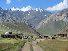
The Alai Valley with the Kysylsuu, which has largely dried up in summer, and the Transalai mountain range of the Pamir |
||
| location | Osh Region ( Kyrgyzstan ) | |
| Waters |
Kysylsuu (Wachsch) , Kysylsuu (Kashgar) |
|
| Mountains | Alai Mountains / Transalaikette | |
| Geographical location | 39 ° 36 ' N , 73 ° 0' E | |
|
|
||
| height | 2500 to 3500 m | |
| length | 180 km | |
The Alai Valley ( Kyrgyz Алай өрөөнү ) is a wide high mountain valley in the Osh region in the extreme south of the Central Asian Republic of Kyrgyzstan . It lies in the two districts Alai and Chong Alai and covers a total of 180 km long from east to west between the Alai Mountains in Kyrgyzstan in the north and the Pamir belonging Transalai chain with the 7134 m high Pik Lenin in Tajikistan in South.
History
The Alai Valley was occupied in 1876 by the Russian Empire , which had expanded into Central Asia since 1853 , after the khanate of Kokand was finally annexed on February 19, 1876 . The northern part of the Kyrgyz settlement area had already been conquered between 1855 and 1863. With the occupation of the Alai Valley, the entire area of what is now the Republic of Kyrgyzstan became part of the Russian Empire.
The valley
The valley floor is at an altitude of 2500 to 3500 m and is about 40 km wide at Sarytasch , where the Pamir Highway crosses the valley. In the west it narrows gradually over the last 40 km and becomes hilly to mountainous until it ends at the small settlement Karamyk, belonging to the municipality of Jekendi, on the border between Kyrgyzstan and Tajikistan. In the east, the valley floor rises to the comparatively low Tongmurun Pass and then extends again to around 8 km west of Irkeschtam , the border station to the Chinese Xinjiang .
The valley is traversed in almost its entire length, with the exception of the eastern 30 km, on its northern flank by the Kysylsuu , which rises east of Sarytasch in the Alai Mountains and flows off to the west. Especially when the snow melts, it is fed by numerous tributaries and spreads in its broad bed of debris . It leaves the valley at the Karamyk Pass through a gorge to Tajikistan, where it is called Surchob and later joins the Muksu to form Surchob . The smaller part of the valley east of the Tongmurun Pass is drained by the river Kysylsuu , which was also initially called Kysylsuu , which rises on the northern flank of the Transalai chain and flows past Irkeschtam to Xinjiang and Kashgar . To distinguish the two rivers in Kyrgyzstan, the western Kysylsuu and the eastern Kysylsuu are sometimes used.
Transport links
A branch of the Silk Road once ran through the valley . Today the roads A 371 and A 372 run along this route , which have been paved with two lanes since 2012. The expansion, which began in 2006, was financed by the Asian Development Bank and the Islamic Development Bank. The A 371 is the eastern end of the Europastrasse 60 . It branches off from the Pamir Highway to the east in Sarytasch and reaches the Chinese border after crossing the 3723 m high Irkeschtam Pass at Irkeschtam, 78 km west of Sarytasch. The A 372 branches off about 2.5 km southwest of Sarytasch from the Pamir Highway to the west and follows the Kyzylsu and runs a total of 136 km through the entire western Alai valley. The border crossing to Tajikistan at the Karamyk Pass at its western end is only passable for Kyrgyz and Tajik citizens.
The 1932 completed section of the Pamir Highway from Kyrgyz Osh in the Ferghana Valley to khorugh in Gorno-Badakhshan in the far east of Tajikistan crosses the Alai Valley from the north over the 3615 m high Taldyk Pass and Sary-Tash coming and leaves it on the south side where the Road is in very bad condition, over the 4250 m high Kyzyl-Art-Pass in the Transalai on the border with Tajikistan.
Economy and living conditions
The climate in the valley is inhospitable, with long and very cold winters. This, the mostly unsuitable soil for arable farming and the seclusion from the traffic point of view explain the extensive lack of permanent settlements. The district of Tschong-Alai, which encompasses the entire western valley, has fewer than 25,000 inhabitants, scattered in mostly small settlements grouped into three communities on the southern slopes of the Alai Mountains or in the northern wind-protected side valleys. Only a few, such as the main town Daroot-Korgon (approx. 5000 inhabitants), Jasch-Tilek , Jekendi , Kyzyleschme , Sary Mogul and Kabyk , are of a certain size. The inhabitants live from cattle breeding (sheep, goats, cattle, horses, camels) and pasture farming. In the summer months, shepherds from other areas, including Tajikistan, come with their families and herds into the valley and onto the side mountain slopes. The harsh living conditions, poverty and the lack of other work opportunities have led to the emigration of many men, so that in many families the care of the animals on the remote high pastures in the mountains is now the task of women.
Individual evidence
- ↑ The two streets were officially opened in November 2012. ( Roads in Kyrgyz Republic will help improve trade with neighboring countries ( Memento of December 3, 2013 in the Internet Archive ))


