
Osh region
|
Osh region Ош облусу |
|||
|
|||
| State : |
|
||
| Capital : | Osh | ||
| Biggest cities: | • Ösgön • Karasuu • Nookat |
||
| Area : | 29,200 km² | ||
| Residents : | 1,130,900 (2011) | ||
| Population density : | 39 inhabitants per km² | ||
| License plate : | 06 | ||
| ISO 3166-2 : | KG-O | ||
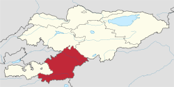  Location of the Osh region in Kyrgyzstan |
|||


The Osh Region ( Kyrgyz Ош облусу Osh oblussu ; Russian Ошская область Oschskaja oblast ) is one of seven regions ( oblast ) in in Central Asia located Kyrgyzstan .
It is located in the central south of the country and is bordered by Uzbekistan to the north and Tajikistan and the People's Republic of China to the south . The area has an area of 29,200 km² and about 1.1 million inhabitants. The population density is relatively high at 39 inhabitants per km² (measured against the population density of the whole country, which is 26 inhabitants per km²).
The administrative center of the area is the city of Osh . It is located near the Uzbek border in the Fergana Valley .
history
Until 1999, the area also included the Batken area , which was then separated for political and religious reasons. Since the area borders directly on the high mountains of Tajikistan, it was considered a retreat for the Islamist combat groups during the civil war there.
Landslides
Due to heavy rainfall , the area is known for landslides . On April 26, 2004, 33 people died in a landslide in Budalyk village, Alai district. The UN emergency aid coordinator reported in its report OCHA / GVA - 2004/0068 that 16 houses were destroyed by the landslide.
A landslide occurred on April 29, 2017 in the village of Aju, in the Ösgön district. Numerous houses were destroyed. According to the Ministry of Crisis Situations, 24 people died. President Almasbek Atambayev described the accident as a tragedy.
population
The March 24, 1999 census showed that the Osh area was home to 1.176 million people. Of these, 272,500 or 23.3% of the population were urban residents and 76.8% were rural residents. The capital Osh and its immediate vicinity concentrated the majority of the city's population with 232,400 inhabitants. Other urban settlements are Ösgön (41,500 inhabitants), Karasuu (19,100 inhabitants), Naiman (1,800 inhabitants) and Sarytasch (1,500 inhabitants).
Ethnically, the population in 1999 consisted of 63.8% Kyrgyz , 31.1% Uzbeks , 1.3% Russians, 0.9% Uyghurs , 0.6% Tatars to 0 .5% from Tajiks and 0.3% from Azerbaijanis ; the remaining 0.6% are divided among different ethnic groups. Most of the Russian-speaking population left the area in the first half of the 1990s. Nevertheless, the population grew by 24.9% between 1989 and 1999, which means almost twice as high a population growth as the Kyrgyz average. The migration balance was negative in 1999, 4205 people left the area and 2845 people moved there.
In 1999, 43.4% of the population was under 16 years old, 7% was over 65 years old, and 49.6% of the population was of working age.
Administrative division
The Osh area is divided into seven districts ( Rajons ). The following districts are located in Osh:
| District structure ( Rajons ) Osh region |
|||
|---|---|---|---|
| District ( Rajon ) |
administrative seat |
location | |
| Ösgön | Ösgön |

|
|
| Karasuu | Karasuu |

|
|
| Arawan | Arawan |

|
|
| Nookat | Eski-nookat |

|
|
| Tschong-Alai | Daroot Korgon |

|
|
| Alai | Validity |

|
|
| Karakuldscha | Karakuldscha |

|
|
Web links
Individual evidence
- ↑ Kyrgyz village hit by landslide. BBC, April 26, 2004, accessed April 30, 2017 .
- ↑ 24 dead as Kyrgyz landslide engulfs village homes. The Straits Times, April 29, 2017, accessed April 30, 2017 .
- ↑ a b c Осмон Ибраимов, Осмонакун Ибраимов: Кыргызстан: энциклопедия . Центр государственного языка и энциклопедии, Bishkek 2001, ISBN 5-89750-129-7 , p. 514 (Russian).
Coordinates: 40 ° 0 ' N , 73 ° 0' E