
Tschüi area
|
Tschüi region Чүй облусу |
|||
|
|||
| State : |
|
||
| Capital : | Bishkek | ||
| Biggest cities: | • Tokmok • Karabalta • Kant |
||
| Area : | 19,895 km² | ||
| Residents : | 803,230 (2009) | ||
| Population density : | 40 inhabitants per km² | ||
| License plate : | 08 | ||
| ISO 3166-2 : | KG-C | ||
| Website : | |||
  Location of the Tschüi region in Kyrgyzstan |
|||


The Tschüi region (also Chui or Chuy ; Kyrgyz Чүй облусу Tschüi oblussu , Russian Чуйская область Tschuiskaja oblast ) is one of seven administrative regions ( oblast ) of Kyrgyzstan in Central Asia . It is the northernmost area of the country and borders on Kazakhstan to the north, Issykköl to the east, Naryn to the south and Talas to the west . The Kyrgyz capital Bishkek lies within the Tschüis region . The area has an area of 19,895 km² and about 803,000 inhabitants (excluding Bishkek, which forms a separate administrative unit). Nevertheless, the administrative center is Bishkek; between 2003 and May 2006 it was Tokmok .
geography

The northern part of the area is very flat, which is unusual for Kyrgyzstan; here is the lowest point of the area at about 550 m above sea level. The valley of the Tschüi River , which is also used for intensive irrigation of the fertile soils in this area, takes up large areas here . The area is of agricultural importance in the cultivation of wheat, maize, sugar beet, potatoes, alfalfa and various types of fruit and vegetables. Due to the agricultural importance of Tschüis, numerous processing companies and industrial plants were built during the Soviet era . B. Tokmok , Kant or Karabalta , have gained regional importance.
In the south of the area, the high mountains of the Kyrgyz Alatau form a natural border with the Talas area to the south. The mountains rise up to a height of 4895 m above sea level. NN ( Alamedinski Pik ) and is home to the Ala Artscha National Park . Due to the proximity to Bishkek, the southern mountains in the region are a popular local recreation destination. There are numerous hiking trails, mountaineering camps and a ski area.
The climate in the northern part is dry and continental, with hot summers and moderately cold winters. The mean July temperatures are between 17 and 25 ° C, the mean January temperature around −7 ° C. The annual rainfall is between 270 and 400 mm. In the south of the area, in the Suusamyr Valley , the average July temperatures are between 13 and 14 ° C, the average January temperatures between −20 and −21 ° C. The annual rainfall there is between 350 and 370 mm.
The waters belong to the catchment areas of the Naryn and Tschüi . On its way through the field of Chu River performs numerous tributaries, including Chong-Kemin and Kitschi-Kemin as right and Schamschy , Kegeti , Ysyk-Ata , Alamüdün , Ala-Archa , Schylamysch , Sokuluk , Ak-Suu River and Karabalta as left inflows, originate in the Kyrgyz Alatau. Today the water from these tributaries often does not reach the Tschüi because it is used for irrigation. In the Tschüi area there are 582 glaciers with a total area of 520 km². Most of it is in the central part of the Kyrgyz Alatau.
population
| Population development in the Tschüi area (source :) |
||
|---|---|---|
| date | Residents | ±% |
| 1970 | 621.004 | - |
| 1979 | 700.063 | + 12.7% |
| 1989 | 796602 | + 13.8% |
| 1999 | 770.811 | −3.2% |
| 2009 | 803.230 | + 4.2% |
There are four cities, five urban-type settlements and 331 villages in the Chüi area . The 2009 Kyrgyz census found the area to have a population of 803,230. The largest cities are Tokmok (53,231 inhabitants), Karabalta (37,834 inhabitants) and Kant (21,589 inhabitants).
The ethnic composition of the Chüis population is more heterogeneous than in other parts of Kyrgyzstan. The Kyrgyz make up the majority with 59.1% . This is followed by Russians with 20.8% of the population and the Dungans with 6.2% . In addition, many other ethnic groups or minorities live in Tschüi, including Uyghurs (1.9%), Uzbeks (1.8%), Kazakhs (1.6%), Ukrainians (1.3%), Azerbaijanis (1.3%) ), Tatars (0.7%) and also Kyrgyzstan Germans (0.7%). The proportion of Germans has fallen sharply since the collapse of the Soviet Union , and the majority of the German minority emigrated to Germany. In 1989, their share in the region was over 9%.
Administrative division
The Tschüi area is divided into eight Rajons . The city of Tokmok (53,087 inhabitants, 41 km² area) corresponds independently to a regional authority on an equal footing with the districts. The city of Bishkek is embedded in the Alamüdün district, but does not itself belong to the Tschüi area, but has administrative territorial status. The following nine districts are located in Tschüi (ordered from east to west):
| District structure ( Rajons ) Tschüi area |
||||
|---|---|---|---|---|
| Rajon | administrative seat |
Pop. | Area (in km²) |
location |
| Alamüdün | Lebedinovka | 147.208 | 1,503 |

|
| Jajyl | Karabalta | 90,348 | 3,435 |

|
| Kemin | Kemin | 41,924 | 3,533 |

|
| Moskovsky | Belovodsk | 83,641 | 2,056 |

|
| Panfilow | Kajyngdy | 39,837 | 2,606 |

|
| Sokuluk | Sokuluk | 158.137 | 2,550 |

|
| Bye | Bye | 44,753 | 1,756 |

|
| Ysyk-ata | Kant | 131.503 | 2,415 |

|
traffic
The main connection between east and west within the area is the Taraz –Bischkek– Balyktschy trunk road , which connects almost all of the major cities in the Tschüi area. The stretch of road west of Bishkek is part of European route 40 ; known locally as the M-39 trunk road from the times of the USSR. The further course of this road leads north of Bishkek over the river Tschüi, the Kazakh border town of Qordai on to the nearby city of Almaty in Kazakhstan.
Rail transport in Kyrgyzstan is out of date and relatively insignificant with a total rail network of 370 kilometers. A large part of the Kyrgyz rail network runs along the Taraz-Bishkek-Balyktschy route in the Chüi region. There is a direct train connection from Moscow to Bishkek.
gallery

South of Bishkek

Ala Artscha National Park
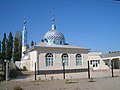
Mosque in Milianfan

Valley of the Tschüi River
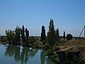
River Tschüi near Korday


Web links
Individual evidence
- ↑ a b c d e Осмон Ибраимов, Осмонакун Ибраимов: Кыргызстан: энциклопедия . Центр государственного языка и энциклопедии, Bishkek 2001, ISBN 5-89750-129-7 , p. 524 (Russian).
- ↑ Thomas Scholl: Kyrgyzstan. To the peaks of Tien-Shan and Pamir. Trescher Verlag, Berlin, 2008; ISBN 978-3-89794-139-7 ; P. 121f
- ↑ a b c d Population and Housing Census 2009. Book 3 (in tables). Provinces of Kyrgyzstan: Chuy Province (Перепись населения и жилищного фонда Кыргызской Республики) 2009. Книга 3 (в таблицах). Регионы Кыргызстана: Чуйская область ( Memento from September 23, 2013 in the Internet Archive ) (PDF; 5.4 MB) Bishkek: National Committee on Statistics, 2010 (Russian)
Coordinates: 42 ° 45 ' N , 74 ° 25' E