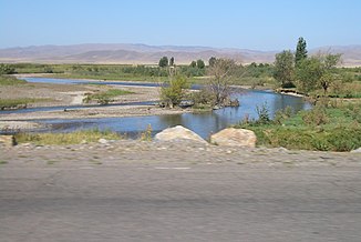
Tschüi (river)
|
Tschüi - Tschu - Schu Чүй, Шу |
||
|
Tschüi in Schu |
||
| Data | ||
| location | Kazakhstan , Kyrgyzstan | |
| River system | Bye | |
| Confluence of |
Dschoon-Aryk and Kochkor near Kochkor ( Naryn region ) 42 ° 13 ′ 16 ″ N , 75 ° 44 ′ 29 ″ E |
|
| Infiltration | In the Asikol depression, coordinates: 44 ° 48 ′ 25 ″ N , 69 ° 58 ′ 15 ″ E 44 ° 48 ′ 25 ″ N , 69 ° 58 ′ 15 ″ E
|
|
| length | 1067 km | |
| Catchment area | 62,500 km² (according to other sources 60,800 km²) | |
| Discharge at the Kochkorka gauge ( ⊙ ) A Eo : 5370 km²
|
MQ 1936/1985 Mq 1936/1985 |
26.9 m³ / s 5 l / (s km²) |
| Left tributaries | Ala-Artscha , Alamüdün , Aksuu , Kuragaty , Ysyk-Ata | |
| Right tributaries | Tschong-Kemin , Kitschi-Kemin , Yrgaity , Kakpatas | |
| Reservoirs flowed through | Ortotokoi , Tashutköl | |
| Medium-sized cities | Tokmok , Schu | |
|
Valley of the Tschüi below Tokmok |
||
|
Course of the Tschüi (Eng. Chu) |
||
The 1067 km long Tschüi ( Kyrgyz Чүй ; Kazakh Шу ; also called Tschu or Schu ) is a river in northern Kyrgyzstan and southeastern Kazakhstan ( Central Asia ).
geography
Upper course : It arises at the southeast foot of the Kyrgyz Mountains above the Ortotokoi reservoir (47 km³ maximum storage volume) from the union of its source rivers ( Dschoon-Aryk and Kotschkor ) and initially heads towards and without reaching or towards the large lake Issykköl flow through, his running turns below the city Ortotokoi to the northwest and winds through the boom gorge between the two mountain ranges of Küngöy Ala-Too Range ( Kyrgyz Күнгөй Ала-Тоо ) and the Kyrgyz Alatau ( Kyrgyz Кыргыз Ала-Тоо ) to Kemin .
Middle reaches : Then it turns to the west and becomes on 221 km of its 336 km total stretch in Kyrgyzstan to the border river to Kazakhstan and flows through the Kyrgyz city Tokmok , from which the cities Kant and Bishkek (Kyrgyz capital) not flowed through by the Tschüi to the west only are a maximum of 100 km away. All of these and the cities mentioned below are located in the 15 to 100 km wide Tschüital , which is lushly overgrown or used for arable farming due to extensive irrigation and opens in a V-shape to the northwest. Below Tokmok, the Tschüi continues to flow through Qordai in a north-westerly direction, and after leaving the common border of the two states at Kaynar , the remainder of the stretch only runs through Kazakh territory, first flowing through the city of Schu .
Lower course : It then separates the Mujunkum desert in the south from the hunger steppe in the north, after which it seeps into the Asikol depression . The latter only happens if it has enough water in years with high rainfall and if too much water is not withdrawn from it for irrigation purposes ; otherwise it will seep away much sooner.
useful information
The Tschüi , from which the name of the northernmost region of Kyrgyzstan ( Tschüi area ) was derived, is one of the many rivers that drain the northern part of the state and seep or evaporate in the deserts and semi-deserts of Kazakhstan. Along with other rivers of the state and especially after the Naryn, which only runs on Kyrgyz territory, it is one of the longest and most important rivers in Kyrgyzstan. Most of the rivers in the northern part of the country are fed by snow and glaciers. Because of the steep gradient in the mountains up to 4875 m high here , high flow velocities of up to 3 m / s are reached, which is why the Tschüi does not freeze over.
The catchment area of the Tschüi covers only 60,800 km².
The area on the Tschüi River was home to around 100,000 Russian- Germans until the last decades of the 20th century , the vast majority of whom were forcibly relocated from their autonomous republic on the Volga during World War II . Most of them moved to Germany after the end of the Soviet Union .
See also
Web links
- Link collections on Kyrgyzstan of the Eastern Europe Network
- Pictures and experiences of a trip through the mountains of Kyrgyzstan
Individual evidence
- ↑ a b Article Tschüi in the Great Soviet Encyclopedia (BSE) , 3rd edition 1969–1978 (Russian)
- ↑ UNESCO: Chu at Kochkorka (discharge data 1936–1985) ( Memento of the original from March 4, 2016 in the Internet Archive ) Info: The archive link has been inserted automatically and has not yet been checked. Please check the original and archive link according to the instructions and then remove this notice.


