Ysyk-ata
|
Ysyk-Ata Ысык-Ата дарыясы |
||
| Data | ||
| location | Tschüi ( Kyrgyzstan ) | |
| River system | Bye | |
| Drain over | Tschüi → Asikol | |
| source |
Kyrgyz mountains 42 ° 26 ′ 16 ″ N , 74 ° 46 ′ 39 ″ E |
|
| muzzle |
Tschüi coordinates: 42 ° 58 ′ 22 " N , 74 ° 54 ′ 10" E 42 ° 58 ′ 22 " N , 74 ° 54 ′ 10" E
|
|
| length | 81 km | |
| Catchment area | 558 km² | |
| Outflow A Eo : 545 km² |
MQ Mq |
7.05 m³ / s 12.9 l / (s km²) |
| Flowing lakes | Ortokelsee | |
| Communities | Yuryevka | |
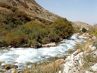
The Ysyk-Ata ( Kyrgyz Ысык-Ата дарыясы ) is a left tributary of the Tschüi in Kyrgyzstan ( Central Asia ).
The Ysyk-Ata rises on the northern flank of the Kyrgyz mountains . It is fed by its glaciers . In the upper reaches it flows through the Ortokelsee . The Ysyk-Ata flows initially in a north-easterly direction, later in an easterly direction through the mountains. It takes in a larger tributary from the right and turns north. The Ysyk-Ata reaches the lowlands of the Tschüital . It flows a piece in a north-westerly direction along the edge of the valley. He passed the located on the right bank location Jurjewka (nearby lies the the neighboring municipality council Syn-Tash belonging Mennonite village of Rot-Front ). Then it turns north and crosses the lowlands. Its course lies between the cities of Kant in the west and Krasnaya Retschka in the east. Finally he reaches the Tschüi across from Karasu . The Ysyk-Ata has a length of 81 km. It drains an area of 558 km². The mean discharge is 7.05 m³ / s.
The catchment area of the Ysyk-Ata lies in the Ysyk-Ata administrative district of the same name .
