
Naryn area
|
Naryn region Нарын облусу |
|||
|
|||
| State : |
|
||
| Capital : | Naryn | ||
| Area : | 45,200 km² | ||
| Residents : | 245,266 (2009) | ||
| Population density : | 5 inhabitants per km² | ||
| License plate : | 05 | ||
| ISO 3166-2 : | KG-N | ||
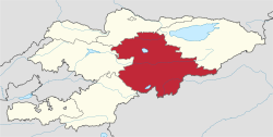  Location of the Naryn region in Kyrgyzstan |
|||


The Naryn region ( Kyrgyz Нарын облусу Naryn oblussu ; Russian Нарынская область Narynskaja oblast ) is one of seven regions ( oblast ) of the Republic of Kyrgyzstan in Central Asia .
It lies in the center of the country and is bounded by the areas of Chüi , Issykköl , Osh and Jalalabat as well as China . The area has an area of 45,200 km² and about 270,000 inhabitants. It was founded at the time of the Kyrgyz Soviet Republic in 1939 as Tjan-Shan Oblast (named after Tian Shan ) and has been using its current name since 1990. The population density of the largest Kyrgyz region is the lowest in the country with 6 inhabitants per km². Naryn also has the highest birth rate in Kyrgyzstan, 25.2 births per 1000 inhabitants in 2005. The name is derived from the Naryn River and the city of the same name, Naryn .
The administrative center of the area is the city of Naryn.
geography
The Naryn area consists mainly of high mountains and plateaus, most of which are more than 2000 m high. In the north is the Songköl mountain lake, the second largest lake in the country after Issykköl . The Kölukök is also located in this area. The river Naryn runs through the area from east to west and is dammed several times.
traffic
Due to its poor location between several high mountain ranges, the Naryn area is poorly developed. Of the two larger roads, one leads from Kochkor (with a connection from Bishkek ) over the 3,030 m high Dolon Pass to the capital of the area. To the south, it reaches the Chinese border at the 3752 m high Turugart Pass . The other road opens up the north of the area and connects Kotschkor over the 3586 m high Töö pass with Kara-Balta , from where there is also a connection to Bishkek.
Administrative division
The Naryn area is divided into five districts ( Rajons ). The following districts are in Naryn:
| Divisions ( Rajons ) Naryn region |
|||
|---|---|---|---|
| District ( Rajon ) |
administrative seat |
location | |
| Ak-talaa | Baetow |

|
|
| Atbaschy | Atbaschy |

|
|
| Jumgal | Chaek |

|
|
| Kochkor | Kochkor |

|
|
| Naryn | Naryn |

|
|
Web links
Individual evidence
- ↑ The Kyrgyz average is 26 inhabitants / km².
Coordinates: 41 ° 30 ' N , 75 ° 30' E