
Batken area
|
Batken region Баткен облусу |
|||
|
|||
| State : |
|
||
| Capital : | Batken | ||
| Biggest cities: | • Kyzylkyja • Isfana • Sülüktü |
||
| Area : | 16,995 km² | ||
| Residents : | 428,800 (2009) | ||
| Population density : | 25 inhabitants per km² | ||
| License plate : | 03 | ||
| ISO 3166-2 : | KGB | ||
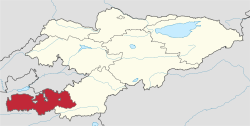  Location of the Batken area in Kyrgyzstan |
|||


The Batken region ( Kyrgyz Баткен облусу Batken oblussu ; Russian Баткенская область Batkenskaja oblast ) is one of seven administrative districts ( oblast ) in Kyrgyzstan in Central Asia .
Batken is located in the extreme southwest of the country and is bordered in the north, south and west by Uzbekistan and Tajikistan . The area has an area of 16,995 km² and about 400,000 inhabitants. It has one of the highest population growth rates in the country at 1.1%. The Aiköl glacier lake is located in the Batken area .
The administrative center of the area is the city of Batken . The area encloses six enclaves : Soʻx , Chon-Qora , Jangail and Shohimardon belong to Uzbekistan, and Kairagach and Woruch belong to Tajikistan .
history
The administrative district has only existed since 1999, when it was separated from the Osh region . This makes it the youngest administrative district in Kyrgyzstan. During the civil war in Tajikistan between 1991 and 1997, Muslim combat groups withdrew, in some cases deep into the mountains of the region, because the border was confusing and difficult to guard. In addition, the Hizb ut-Tahrir and the Islamic movement of Uzbekistan , which has its stronghold in the neighboring Ferghana Valley, are active here.
traffic

The area is poorly located in terms of traffic in the middle of high mountains (foothills of the Pamir ) that separate it from the rest of the country. The only trunk road in the direction of Osh and Bishkek runs partly through Uzbek territory. Most of the connecting roads within the area also run through the enclaves of neighboring countries. The only border crossing with Tajikistan is Kyzyl Bel between the cities of Batken and Isfara .
Administrative division
The Batken area is divided into three districts ( Rajons ). The following districts are in Batken:
| District structure ( Rajons ) Batken area |
|||
|---|---|---|---|
| District ( Rajon ) |
administrative seat |
location | |
| Batken | Batken |

|
|
| Kadamjai | Pulgon |

|
|
| Leilek | Isfana |

|
|
Web links
Individual evidence
- ↑ Wostok Special 1/2007; R. Abdymomudow, The demographic development
Coordinates: 40 ° 0 ′ N , 70 ° 50 ′ E