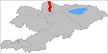
Sokuluk district

Sokuluk is a Rajon ( district ) in the Tschüi area in northern Kyrgyzstan . According to a census from 2009 , 159,231 people live in the Rajon, the main town of which is the municipality of the same name, Sokuluk .
location
The Rajon with an area of 2550 square kilometers is located in the north of the country. In the south, Sokuluk borders the Panfilov Raion with the main town of Kajyngdy , to the west the Moskva Raion joins the capital Belovodsk , and to the east the Alamüdün Raion , which surrounds the Kyrgyz capital Bishkek , which forms a separate administrative unit. In the north the Sokuluk Rajon borders on the neighboring country Kazakhstan , the place Kamyshanovka is the most important place in the border area on the Kyrgyz side.
The geography of the region is characterized by the northern foothills of the Kyrgyz mountains , which extend to the south of the Rajon. There is the source of the Sokuluk River , which flows into the Aksuu , which in turn is a tributary of the Tschüi . This forms the border with Kazakhstan in the northeast of the Rajon. The Tschüi river system and the Great Tschüikanal ensure the region's water supply and are used for irrigation in agriculture . According to an evaluation from 2004, 56,604 hectares were irrigated for agricultural purposes in Sokuluk district , which corresponds to around 22% of the total area of the area.
traffic
The region's transport infrastructure benefits from its proximity to the capital Bishkek in the east of the Rajon. The Kyrgyz highway M39 runs in an east-west direction through the Rajon. The trunk road is part of the European route 40 , which leads from Calais in France to Ridder in Kazakhstan . The Lugovoi – Bishkek railway , which connects the Kazakh city of Lugovoi in the west and Bishkek in the east, also runs through the Sokuluk district. On the Kazakh side of the border in the north of the Rajon, the A2 formed one of the most important road connections in the region and can be reached from the Kyrgyz side via a border crossing at Kamyshanovka.
places
The largest town in the Rajons is the main town Sokuluk with 24,417 inhabitants (2009). Other important places are Schopokow with 8,749 inhabitants, Dzhany-Dzher with 5,979 inhabitants and Kysyl-Tuu with 4,418 inhabitants.
Individual evidence
- ^ Sokuluk district. Retrieved August 10, 2020 (de-US).
- ↑ Jenniver Sehring: Water User Associations (WUAs) in Kyrgyzstan A Case Study on Institutional Reform . Ed .: Center for international development and environmental research at the Justus Liebig University in Giessen. No. 24 . Giessen August 2005, p. 6-14 .
- ↑ Транспорт - Сфера услуг - Экономика. Retrieved August 10, 2020 (Russian).
- ↑ Stephan Flechtner, Dagmar Schreiber: Kyrgyzstan travel guide to the peaks of Tien-Schan and Pamir . 6., update Edition, revised edition. Trescher Verlag, Berlin, ISBN 978-3-89794-483-1 , p. 143 f .
- ↑ Kyrgyz Census 2009. Retrieved on August 10, 2020 (Russian).
