Surchob
|
Surchob Сурхоб |
||
| Data | ||
| location | Tajikistan | |
| River system | Amu Darya | |
| Drain over | Wachsch → Amu Darya → Aral Sea | |
| Confluence of |
Kysylsuu and Muksu 39 ° 16 ′ 8 " N , 71 ° 22 ′ 48" E |
|
| Association with |
Obichingou zum Wachsch coordinates: 38 ° 52 ′ 2 " N , 70 ° 1 ′ 40" E 38 ° 52 ′ 2 " N , 70 ° 1 ′ 40" E
|
|
| length | approx. 150 km | |
| Discharge at the Gharm gauge ( ⊙ ) A Eo : 20,000 km²
|
MQ 1937/1985 Mq 1937/1985 |
325 m³ / s 16.3 l / (s km²) |
| Small towns | Tojikobod , Gharm | |
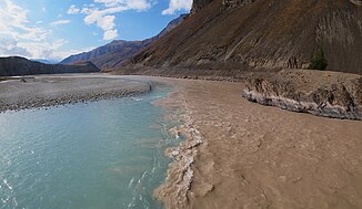
The Surchob ( Tajik Сурхоб ) is the right source river of the Wachsch in Tajikistan .
The Surchob arises at the confluence of the Kysylsuu ( Kysylsu ) and Muksu . It flows over a distance of 150 km in a west-southwest direction. Finally it unites with the Obichingou flowing in from the east to form Wachsch. The Surchob drains the southern flank of the Alai Mountains . The A372 trunk road runs along the river. The towns of Tojikobod and Gharm are on the riverside. At the Gharm discharge level, the mean discharge is 325 m³ / s. In the summer months of July and August, the Surchob carries the largest amount of water.
Individual evidence
- ↑ a b UNESCO: Vakhsh, Surkh-Ob at Garm (discharge data 1937–1985) ( memento of the original from December 17, 2005 in the Internet Archive ) Info: The archive link was automatically inserted and not yet checked. Please check the original and archive link according to the instructions and then remove this notice.
