Alay Mountains
| Alai Mountains - Alaikette - Alai | ||
|---|---|---|
|
View from the Dschiptik valley to the north on the Alai mountains |
||
| Highest peak | Peak Tandykul ( 5544 m ) | |
| location | Kyrgyzstan , Tajikistan , Uzbekistan , Xinjiang ( PR China ) | |
|
|
||
| Coordinates | 39 ° 27 ' N , 71 ° 5' E | |
| surface | 7,000 km² | |
|
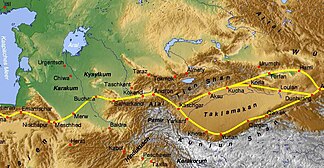
Central Asia with part of the Silk Road , in the center the Alai Mountains |
||
The Alay Mountains or Alaikette or Alai (not to be confused with the east gelegenem Altai ) is a Central Asian mountains .
The mountain range with a height of up to 5544 m and a length of 400 kilometers extends from west to east and partially forms the border region between Kyrgyzstan and Tajikistan . Western foothills are also on the territory of Uzbekistan . The easternmost part of the mountain is already part of the territory of China , where the Tarim basin joins the Takla Makan desert near Kashgar . The highest point of the eastern Little Alai ( Kitschi-Alai ) is the ( 5069 m ) high Pik Skobelew .
The Alai is separated from the Tianshan mountain range to the north by the Fergana Valley and the upper reaches of the Syr Darja and its source river Qoradaryo . To the south, the rivers of Kysylsuu and Kashgar and the wide Alaital through which the Kysylsu flows form the natural border with the Pamir massif . The mountain range that is part of the Pamir and is located south of the Alai with the Lenin peak is the Transalai Mountains .
The section of the Pamir Highway, completed in 1932, from the Kyrgyz Osh in the Fergana Valley to Chorugh in Berg-Badachschan in the far east of Tajikistan crosses the mountains over the 3615 m high Taldyk Pass and reaches the Alaital Valley at Sarytasch .
Mineral finds
The Alai Mountains, more precisely the area around the Dara-i-Pioz ( Darai-Pioz ) glacier , is a well-known site for many minerals and their varieties . A total of 128 minerals and 9 varieties have been detected there so far (as of 2011). For 29 minerals Dara-i-Pioz is also regarded as a type locality , including the named after the glacial Darapiosit , named after the adjacent state Tadschikistan Tadzhikit- (Ce) , named after the adjacent mountain Tienshanit and after the region Turkestan named Turkestanit .
literature
- August Petermann, Ernst Behm, Paul Max Harry Langhans, Nikolaus Creutzburg, Hermann Haack: Petermanns geographical communications . 2004.
- Klaus Pander: Central Asia: Uzbekistan, Kyrgyzstan, Tajikistan, Turkmenistan, Kazakhstan . Mair Dumont Dumont, 1996, ISBN 3-7701-3680-2 .
Individual evidence
- ↑ Article Alai Mountains in the Great Soviet Encyclopedia (BSE) , 3rd edition 1969–1978 (Russian)
- ↑ Mindat - description of the location and mineral list of Darai-Pioz (Dara-i-Pioz; Dara-Pioz) Glacier, Alai (Alayskiy) Range, Tien Shan Mts, Region of Republican Subordination, Tajikistan
- ^ Tienshanit on mindat.org
- ↑ Turkestanite on mindat.org


