Kaxgar (city)
| Uighur name | |
|---|---|
| Arabic-Persian (Kona Yeziⱪ) : | قەشقەر شەھىرى |
| Latin (Yengi Yeziⱪ) : | Ⱪəxⱪər Xəⱨiri |
| Cyrillic ( Soviet Union ): | Қәшқәр шәһири |
| official notation ( PRCh ): | Kaxgar |
| other spellings: | Kashgar, Kashgar |
| Chinese name | |
| Abbreviation : | 喀什 市 |
| Transcription in Pinyin : | Kāshí Shì |
| Wade-Giles transcription : | K'a-shih |
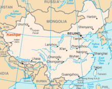
The independent city of Kaxgar or Kashgar ( Chinese 喀什 市 , Pinyin Kāshí Shì or Kashi , Uighur قەشقەر شەھىرى Kashgar shehiri , Yengi Ⱪəxⱪər Xəⱨiri , orig . Kāš , with the additional East Iranian -γar , "-berg"; old Chinese name 伽师 , Jiāshī ) is the capital of the Kaxgar administrative district , located in the Xinjiang Uyghur Autonomous Region of the People's Republic of China .
It lies on the edge of the Tarim basin at an altitude of 1235 to 1300 m and has an area of 96 km². It is an oasis city in the inland delta of the Kyzylsuu River and forms an important junction on the Silk Road between the Hexi Corridor and the Wachsch - Amudarja .
According to the 2000 census, the city of Kaxgar had 340,640 inhabitants (population density: 3,548.33 inhabitants / km²). The population is predominantly Uighur and thus influenced by Islam .
history
The city was only mentioned in Chinese sources around the turn of the century and, according to the work of Han Shu, was one of the 48 principalities of the West. With brief interruptions, it was under Chinese rule. The Chinese supremacy weakened in the 2nd century and the local rulers got their legitimation from the Yuezhi and Kushans . In the 3rd century Kaxgar was one of the six centers of power in the west and is also mentioned in the Sassanid inscriptions of King Shapur I , who counted Kaxgar among his ultimate possessions after the conquest of Kushana. In the 6th century Kaxgar belonged to the Hephthalites before it came under the rule of the first khaganate of the Kök Turks .
The expanding Tang Dynasty defeated the Kök Turks in the middle of the 7th century. The local rulers were again under Chinese rule. The Chinese pilgrim monk Xuanzang visited the city around 640 and reported on agriculture, factories and hundreds of Buddhist monasteries in the area. From 676 to 678 the Tibetans raided the city, but the Chinese were able to regain control. The first Islamic attack occurred in 715 and just a few years later the Uighurs conquered the region. These were replaced by the Qarakhanids , whose ruler Satuq Bugra Qara Qagan converted to Islam in the middle of the 10th century, so that over time Kaxgar also became Muslim. Kaxgar as part of the Eastern Karakhanid Empire became a center for Islamic teachings. The scholar Mahmud al-Kāshgharī describes the city and a field of ruins Mān-känd near the city. In addition, according to Kāshgharī, the city was also called Ordu-känd as the seat of the army and administration.
In 1211 the usurper Kütschlüg of the Kara Kitai drove the Karachanids out of Kaxgar and banished Islam. In 1220 the Mongols subjugated the region. After the division of the Mongol Empire, Kaxgar came to live with Genghis Khan's son Chagatai Khan . His family ruled the region as Chagatai Khanate until the 17th century. Marco Polo visited Kaxgar (he called the city Cascar ) around 1273 and noticed the high number of followers of Nestorianism . Other ruling dynasties included the Timurids between the 14th and 15th centuries. During his affiliation to the Timurid Empire , Timur appointed a governor here in 1377/78. During the Islamic Yarkant Khanate there was a conflict between Kaxgar and Yarkant , as a result of which Kaxgar's inner city was destroyed in 1514. The destroyer Kaxgars Mirzā Abu Bakr had a new city built, which is now known as the old town of Kaxgars. After 1514 Yarkant became the new center of the region.
Kaxgar belonged to the Djungarian Khanate , which was established in 1640, and was conquered by the Chinese of the Qing Dynasty in 1758 . In 1884 the city became part of Xinjiang Province . The Qing rule was interrupted by several revolts (1825–28, 1830, 1847 and 1857), the most famous of which was the revolt of Jakub Beks between 1865 and 1877; he called himself 'Emir of Kashgaria'. In 1857 Adolf Schlagintweit was beheaded in Kaxgar on charges of espionage. In the middle of the 19th century, Kaxgar was an important place in the so-called Great Game of the colonial powers Russia and Great Britain. The Russians had conquered the adjoining territories and khanates in the region. Kaxgar himself remained part of China even after the People's Republic of China was proclaimed .
present
The Chinese government is currently carrying out an extensive modernization of the city, in the course of which, however, the historic old town will be almost completely destroyed. In July 2009, the Society for Threatened Peoples raised violent allegations about the destruction of the unique cultural heritage: “The more than 2000 year old old town of the city of Kaxgar in northwest China is threatened with destruction. Over the next five years, around 200,000 people are to be relocated to so-called earthquake-proof apartment blocks. The project, which began on February 27, 2009, calls for the destruction of 85 percent of the centuries-old building fabric. Kaxgar is considered to be the most historically important Islamic city in Central Asia. Only 15 percent of the old houses are to be preserved as part of an open-air museum in order to show the old Islamic culture to the 1.5 million tourists from home and abroad every year. ”A large number of the Uyghur residents of the old town see the lack of earthquake security but only a pretended reason for the renewal and accuse the Chinese government that the renewal of the old town is primarily intended to serve security policy goals. The Chinese government, on the other hand, promises that a large number of the historical buildings will be faithfully reproduced.
Ethnic breakdown of the population (2000)
| Name of the people | Residents | proportion of |
|---|---|---|
| Uighurs | 263.507 | 77.36% |
| Han Chinese | 74.184 | 21.78% |
| Hui | 988 | 0.29% |
| Uzbeks | 699 | 0.21% |
| Tajiks | 253 | 0.07% |
| Kyrgyz | 231 | 0.07% |
| Manchu | 142 | 0.04% |
| Mongols | 138 | 0.04% |
| Zhuang | 98 | 0.03% |
| Tujia | 85 | 0.02% |
| Miao | 77 | 0.02% |
| Kazakhs | 38 | 0.01% |
| Russians | 37 | 0.01% |
| Others | 163 | 0.05% |
Climate table
|
Average monthly temperatures and rainfall for Kaxgar
Source: wetterkontor.de
|
|||||||||||||||||||||||||||||||||||||||||||||||||||||||||||||||||||||||||||||||||||||||||||||||||||||||||||||||||||||||||||||||||||||||
Transport and infrastructure
Kaxgar is a traffic hub and serves as the starting point of the Karakoram Highway , which connects the city with Islamabad ( Pakistan ). Furthermore, the highways to Kyrgyzstan begin here over the Torugart Pass to Bishkek , and over the Irkeschtam Pass to Osh . Kaxgar has an airport and is connected to the rail network via the Kaxgar train station . In addition, the city is the center of an extensive irrigation system.
tourism
The city is famous for the weekly Sunday market and its large covered bazaar. On the Sunday market animals (sheep, goats, donkeys, cattle, yaks, horses, occasionally also trample ) and agricultural supplies, on the bazaar all kinds of household items, food, Uighur-Chinese medicine and haircuts are offered.
building
The great Heytgah Mosque , the largest in China, is in the heart of the city. The Apak Hodja mausoleum , which was built in the 13th century, is also located in Kaxgar. Five generations of his family are buried in the mausoleum. He ruled over Kuqa , Aksu , Korla , Yarkant , Hotan and Kaxgar.
The 18 m high statue of Mao Zedong is one of the largest in China.
environmental issues
Kaxgar is grappling with massive air pollution. In March 2016, according to the Chinese website aqicn.org, along with the western Chinese cities of Aksu and Korla , the air in the village had the worst possible value. During the ongoing measurement, the limit values for ozone , fine dust (PM 10 and PM 2.5 ), nitrogen dioxide , sulfur dioxide and carbon monoxide are regularly exceeded.
literature
- Friedrich Marthe: Walichanof's trip to Kashgar . 1870 ( Wikisource )
Web links
- Pavel Lurje: Kashgar . In: Ehsan Yarshater (Ed.): Encyclopædia Iranica , as of May 1, 2012 (English, including references)
Individual evidence
- ^ Jürgen Paul : Central Asia. S. Fischer, Frankfurt am Main 2012 ( Neue Fischer Weltgeschichte , Volume 10), p. 264
- ^ Jürgen Paul : Central Asia. S. Fischer, Frankfurt am Main 2012 ( Neue Fischer Weltgeschichte , Volume 10), p. 260.
- ↑ gfbv.de (PDF)
- ↑ youtube.com
- ↑ Statistics. aqicn.org
- ↑ Current values. aqicn.org
Coordinates: 39 ° 27 ' N , 75 ° 59' E


