Yarkant
| Uighur name | |
|---|---|
| Arabic-Persian (Kona Yeziⱪ) : | يەكەن ناھىيىسى |
| Latin (Yengi Yeziⱪ) : | Yəkən naⱨiyisi |
| Cyrillic ( Soviet Union ): | Йәркәнд наһийиси |
| official notation ( PRCh ): | Yarkant |
| other spellings: | Yarkand |
| Chinese name | |
| Abbreviation : | 莎车 县 |
| Traditional characters : | 莎車 縣 |
| Transcription in Pinyin : | Shāchē Xiàn |
Yarkant , also called Jarkand or Jarkend , is a district of the Kashgar administrative district in the Xinjiang Uyghur Autonomous Region of the People's Republic of China . It has an area of 7960 km².
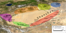
Its main town is the large community of Yarkant ( Shache Zhen莎车 镇) (38 ° 24'51 "N, 77 ° 14'49" E) between the cities of Kashgar and Hotan on the southern route of the Silk Road in the west of the Tarim Basin .
Yarkant was the center of the Islamic Yarkant Khanate , which existed from 1514 to 1680.
Web links
Commons : Yarkant - album with pictures, videos and audio files
- The Uighur nationality (3). China Radio International CRI, April 3, 2006, accessed March 4, 2013 .
Individual evidence
Coordinates: 38 ° 52 ' N , 77 ° 29' E


