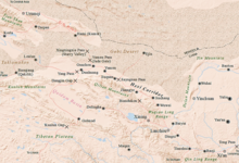
Hexi corridor


The Hexi Corridor ( Chinese 河西走廊 , Pinyin Héxī Zǒuláng ) or Gansu Corridor ( 甘肅 走廊 / 甘肃 走廊 , Gānsù Zǒuláng ) is located in the Gansu Province in China . It covers an area of about 215,000 km² . As part of the Silk Road in ancient China, it is the most important passage to Xinjiang and Central Asia .
geography
The corridor is located on the northwest bank of the Huang He and is a narrow, elongated passage over 1,000 kilometers long and up to 100 kilometers wide. It extends in a west-east direction from the hills of Yumenguan on the border with Gansu and Xinjiang to the steep slopes of Wushaoling near today's city of Lanzhou and in a south-north direction between the Qilian Shan mountains (as the northern border of the Highlands of Tibet ) and the mountains of Longshou Shan and Heli Shan , to which the Gobi desert connects to the north . The Hei He and Shule rivers flow through it . Many of the fertile oases in it are surrounded by desert and semi-desert.
As a result of the accumulation of meltwater from the Qilian Shan, whose glaciers feed the springs of the rivers, agriculture and livestock farming is possible in a number of oases. Cities are (from west to east) Dunhuang , Guazhou , Yumen , Jiayuguan , Jiuquan (formerly Fulu), Zhangye , Jinchang , Wuwei and finally Lanzhou in the southeast.
This route, which has been important since ancient times, is now crossed by the Lanzhou-Xinjiang railway line.
In the west lies the Tarim Basin and behind it Central Asia and in the east the Chinese heartland . Behind the mountains lies Tibet in the south and the Gobi desert in the north .
history
The mountains and the desert limit possible trade routes to a narrow corridor, the east-west traffic of the Silk Road could be controlled with a few fortresses - this explains the importance of this area. Two important passes enabled the route to the west: the Yumenguan (Jadetor Pass) north of Guazhou and the Yangguan (Southern Pass) west of Dunhuang.
The Han dynasty succeeded in 121 BC. To drive the Xiongnu out of this area. This meant a considerable strategic advantage for the Chinese over the steppe kingdom of the Xiongnu, who were defeated several times by the Han troops in the following years. This resulted in an expansion of the Chinese sphere of influence into the Tarim Basin . During the Tang Dynasty , the Chinese fought with the mighty Kingdom of Tibet for control of the Tarim Basin, with the Tibetans acting more successfully overall. From 982 to 1227 the corridor was ruled by the Tangut Xixia , who were thus in competition with the Uyghurs and Tibetans.
During and after the Mongol conquest in 1227, the cities in the Hexi Corridor were badly damaged and their population declined. A reconstruction is reported from 1266 onwards. In the 14th century, the plague caused a further decline in population. At the end of the 15th century, when the Kazakhs advanced, there were probably only a few urban settlements left.
literature
- Sabira Ståhlberg: The Gansu Corridor: barbarian land on both sides of the Great Wall of China; to the north-south dialogue of a Central Asian region. Kovač, Hamburg 1996, ISBN 3-8606-4470-X .
- Jürgen Paul : Central Asia. S. Fischer, Frankfurt am Main 2012 ( New Fischer World History , Volume 10).
Remarks
- ↑ Cf. Wicky WK Tse: The Collapse of China's Later Han Dynasty, 25-220 CE. The Northwest Borderlands and the Edge of Empire. Abingdon 2018, p. 36f.
- ^ Christopher Beckwith: The Tibetan Empire in Central Asia. Princeton 1987, pp. 28ff.
- ^ Jürgen Paul: Central Asia. Frankfurt am Main 2012, pp. 138f.
- ^ Jürgen Paul: Central Asia. Frankfurt am Main 2012, p. 293.
- ^ Jürgen Paul: Central Asia. Frankfurt am Main 2012, p. 299.