
Gobi
| Gobi desert
戈壁 / 戈壁滩 / 戈壁 沙漠
|
||
|---|---|---|
 Rocks, rubble and gravel shape the image of the Gobi desert, such as B. here at the Bajandsag rock formation in Mongolia. |
||
| location |
|
|
|
||
| Coordinates | 42 ° N , 103 ° E | |
| surface | 2.35 million km² | |
 Sandy deserts with dunes or sandy areas, such as B. here the Badain Jaran desert in China, alternate with the stone desert. |
||

The Gobi Desert , or the Gobi for short ( Mongolian Говь Gow , Chinese 戈壁 , Pinyin Gēbì ), is an extensive dry area in Central Asia , Mongolia and China . It consists of contiguous, diverse desert and semi-desert landscapes. Particularly characteristic are the extremely arid, mostly stony and rarely sandy deserts in China, as well as the more life-friendly, wide steppes in Mongolia. With 2.3 million km² it is one of the largest non-polar desert regions on earth .
geography
The Gobi Desert is a vast arid region located in mid-latitude on the Mongolian Plateau in the interior of the Asian continent. In north-west China it includes the contiguous desert areas of Junggar Gobi , Gaxun Gobi , Alashan Shamo and Erdos Shamo , in south Mongolia the Trans-Altai-Gobi , and in south-east and east Mongolia the east Gobi or Mongolian Gobi . Numerous other partial deserts are distinguished within these desert regions. It is roughly bordered by large mountain ranges. These are the Altai and Changai Mountains in the north, the western edge of the Da Hinggan mountain range in the east , Qilian Shan and Bei Shan in the south, and the eastern foothills of the Tian Shan in the west . The sandy deserts of Kumtag , Lop Nor and Taklamakan in the west of the Tarim Basin do not belong to the Gobi Desert . These are connected to it by the Hexicorridor , but separated from it by the Kuruktagh and Beishan mountain ranges .
For a long time, the boundaries of the Gobi Desert were only vaguely defined. The Xamo Desertum area was already shown on some maps from the 17th century as a strip that is clearly delimited and surrounded by a series of mountains, but a systematic survey did not take place until the beginning of the 21st century. Using modern scientific criteria such as the NDVI vegetation index, deserts can be identified in satellite images. Thus it was found that the boundary of the Gobi desert varies under the influence of changing anthropogenic and climatic factors every year. For 1982 the area was 1.16 million km², which decreased slightly in the following years. For 1988 a sudden increase to 1.57 million km² was noted. The area then decreased significantly again, but without reaching the old value. It is believed that this was the result of the El Niño from 1982–1983 and a particularly warm winter and spring in 1989/1990. A more recent study with satellite images, which also uses an aridity index to define the desert area, showed a much larger value for the area. For the period from 2000 to 2012 the average area was 2.35 million km². The value varied between 2.08 million km² in 2009 and 2.47 million km² in 2012. This makes the Gobi desert one of the largest non-polar deserts on earth after the Sahara and the Arabian deserts.
Partial deserts
| The structure of the Gobi desert ( map with all coordinates: OSM | WikiMap ) |
|||
|---|---|---|---|
| Desert region | Partial desert | Area km² |
Precipitation mm / a |
|
Junggar Gobi ( 45 ° N , 88 ° E ) |
48,800 | 70-150 | |
| Gaxun Gobi ( 42 ° N , 92 ° O ) |
83,860 | ~ 20 | |
| Trans-Altai Gobi ( 44 ° N , 98 ° E ) |
Nomingyyn Gobi ( 44 ° N , 95 ° O ) | <100 | |
| Zahui Zarmangyyn Gobi ( 45 ° N , 96 ° O ) | |||
| Shargyyn Gobi ( 46 ° N , 95 ° O ) | |||
| Honin Usnyy Gobi ( 46 ° N , 93 ° O ) | |||
| Khongoryn Els ( 44 ° N , 103 ° E ) | 130 | ||
| Alashan Shamo ( 40 ° N , 103 ° E ) |
Badain Jaran Shamo ( 40 ° N , 102 ° E ) | 52,162 | 35-115 |
| Tengger Shamo ( 38 ° N , 104 ° E ) | 76,845 | ||
| Ulan Buh Shamo ( 40 ° N , 106 ° E ) | 24,422 | ||
| Galbyyn Gobi ( 43 ° N , 107 ° O ) | |||
| Borzongyyn Gobi ( 42 ° N , 105 ° O ) | |||
| Zag Suujyyn Gobi | |||
| Uushyyn Gobi | |||
|
Erdos Shamo ( 39 ° N , 109 ° E ) |
Kubuqi Shamo ( 40 ° N , 109 ° O ) | 26,984 | 240-360 |
| Mu Us Shadi ( 39 ° N , 109 ° E ) | 55,683 | 250-400 | |
| East Gobi ( 44 ° N , 111 ° E ) |
Ööshiin Els ( 45 ° N , 107 ° O ) | ||
| Ööshiin Gobi ( 44 ° N , 109 ° O ) | |||
| Dalay Els ( 44 ° N , 111 ° E ) | |||
| Ar Jiremiïn Gobi ( 46 ° N , 112 ° O ) | |||
| Hulun Buir Shadi ( 49 ° N , 119 ° E ) | 29,200 | 250-350 | |
| Ujimqin sandy land ( 45 ° N , 116 ° O ) | 26,017 | ||
| Otindag sandy land ( 42 ° N , 115 ° O ) | 29,220 | 200-350 | |
| Horqin Shadi ( 43 ° N , 119 ° E ) | 52,300 | 360 | |
| Hunshandake Shadi ( 43 ° N , 115 ° O ) | 127,760 | ||
| Bayan Ondor ( 42 ° N , 110 ° E ) | 105.184 | ||
Bejshan
The Bejschan (also Beishan ) is a mainly mountainous desert, it is therefore sometimes classified as a mountain range. It represents a link between the Gobi steppe in the east and the Tarim basin in the west.
Monod classified Bejshan as a desert of its own, as certain animal and plant species occur here and thus forms its own ecosystem. In addition, there is its own geological structure. The area is delimited in the south by the Nanschan Mountains, in the north by the Mongolian border, in the east by the river Edsin Gol, followed by the Alashan.
Today, an expressway connects Xinjiang with eastern China through the desert .
Alashan
The Alashan (also Alaschan , Mongolian Alxa ) is a sandy desert southwest of the Gobi, which is known in China with the partial desert names Tengger (Tenggeli Shamo) and Badain Jaran (Badanjilin Shamo / Badan Jilin Shamo). It is delimited in the south by the extension of the Nanschan Mountains, in the southeast by the Yellow River , in the east by the Alxa or Helan-Shan Mountains, and to the north by the Yellow River. In the north it extends to the Mongolian border, in the west the Bejschan joins. The landscape has a general altitude of 1000 to 1500 m. In Badain Jaran lies the Biluthu , the highest sand mountain in the world at 1610 meters.
The naming is controversial as some scientists use the term "Alashan-Gobi" and see it as part of the Gobi. "Gobi" is supposed to stand for the shape of the rocky and scree desert. Sometimes the term Alashan itself is avoided. Instead, the region is further subdivided into the Badain Jaran and Tengger (Mongolian: "wide sky") deserts.
According to researcher Prschewalski , the Alashan is a plain that probably once formed the bed of a large lake or sea. He deduced this from the flat shape of the region as a whole and the salt plains including salt lakes in the deepest parts. In the Tengger Desert in particular, nothing can be seen for hundreds of kilometers but bare sand; hence the Mongolian name "Tengger" for wide sky. There are almost no oases in the Alashan. There is also gravel instead of yellow sand near the adjacent mountains.
In the western part of the Alashan there are dunes that are up to 520 m high ( Biluthu ) and thus represent the highest dunes on earth. Of the 140 salt lakes that can be found between the dunes, some are considered sacred to the Mongols. Therefore, there are also Lamaist monasteries here. The inhabitants today are mainly Han , Mongols and Hui .
climate

The Gobi is a desert with a continental climate . In its largest part, in the Mongolian Gobi in the east, there is a cold steppe climate . This goes west of the 110th degree of longitude, from about the Ordos Shamo, into a cold desert climate . Further west, from the 106th degree of longitude, with the beginning of the Alashan Shamo, the altitude decreases, there is hardly any vegetation and sand dunes appear.
The Gobi is not the driest desert, but it is the one with the greatest temperature differences. In winter temperatures often drop as low as -30 ° C and sometimes even as low as -40 ° C. In summer temperatures often reach 35 ° C in the shade and stone surfaces heat up to 65 ° C or more. The nights are always cold, however, while the mean temperatures during the day are 20 to 25 ° C.
In winter and spring there can be light snowfalls, but these rarely cover the ground with a few centimeters. Summer is the rainy season with few but often torrential rains. Precipitation reaches a maximum of 390 mm / a in the East Gobi and decreases towards the west. The Gaxun-Gobi is the driest area with precipitation levels of approximately only 20 mm / a.
designation


The term Gobi is used ambiguously. On the one hand, it stands for the geographic object Gobi Desert, that is to say for a specific dry area in Central Asia that has a somehow defined boundary and bears the name Gobi. On the other hand, the word Gobi is also used as a geomorphological synonym for stone desert , which is a dominant landscape element in the Gobi desert. In the Gobi desert, contemporary geography distinguishes between Gobi for the stony landscapes and Shamo for the sandy landscapes.
Originally, the inner-Asian deserts got their names from the local minorities. In China, these terms were later transliterated from the local languages into the Chinese script , often with a change in their meaning. The Sino-Mongolian desert belt was completely unmanageable and almost endless for early European trade travelers. To get from the Middle East to China, the difficult and dangerous crossing of the sandy plains and bare mountains of the “great desert”, as Marco Polo called it in the 13th century , took a whole month at its narrowest point. The Mongols called the desert Govi or Kébé, which meant "waterless place" and comes close to the modern definition of desert. In the 17th century, the name Gobee A1 was first mentioned on European maps. At the same time, as the Europeans perceived it and noted it on their maps, the Gobi desert in China was also known as Sha-mo ( 沙漠 ), which actually means sand desert.
However, in China and Mongolia, the Gobi Desert has been and is differentiated more geographically and geomorphologically into partial deserts and other names may be used. When it comes to geomorphological classification, gobi is only used if more than 50% of the area is covered by loose, unsorted rubble and gravel with a diameter of 4 to 64 mm. An example of such a regional geomorphological unit is the Junggar Gobi ( 准噶尔 戈壁 ) on the northwestern extreme of the Gobi Desert in China. According to this definition, around 43.5% of all Chinese desert areas are Gobi deserts, i.e. stony deserts. The Junggar Gobi is also an example of the fact that even today, for historical reasons, different names are used in inconsistent spelling for the same area. It is also known as the Gurbantünggüt, Gurban Tunggut, Djungarian or Dzoosotoyn-Elisen desert. A2
If the sand is blown by the wind and forms large areas or small dunes, then in China the term shazhi huangmo ( 沙质 荒漠 "sandland") is used, such as Hunshandake Shazhi Huangmo ( 浑善达克 沙地 , English "Hunshandake") Sandy Land ", German" Hunshandake-Sandland ") at the eastern extreme of the Gobi Desert in China. 45.3% of all Chinese desert areas are such sandy deserts. In Mongolia, the sandy deserts are called Els, such as B. the dune field Khongoryn Els .
The remaining arid areas are steppes with semi-stable or stable dunes and sand areas that are referred to in China as shadi ( 沙堤 ) or sand land , such as Horqin Shadi ( 科尔沁 沙地 ), also located at the eastern extreme of the Gobi desert. 11.2% of all Chinese desert areas are steppes.
Finds
Many important fossils , including fossils, from different geological epochs have been found in the Gobi . Most of the finds of dinosaur eggs and entire nests come from here. In previous sections of the earth's history, different climatic conditions prevailed with lush vegetation, which provided correspondingly good living conditions for dinosaurs .
history
The Gobi is best known in history as part of the Mongol Empire . There are also some important trading cities on the Silk Road on the southern edge of the Gobi.
ecology
Numerous animal species can be found in the Gobi Desert and the surrounding regions, including wolves , jiggetai , goitered gazelle , gerbil and steppe iltis . There are also some snow leopards .
The desert is home to some drought-adapted shrubs and grasses. However, the area is very vulnerable to grazing and vehicles. Human influences are greater, especially in the eastern part, where more rain falls and livestock farming is worthwhile. In Mongolia , grasslands have recently been pushed back by the greater proportion of goats in the herd. The goats provide valuable cashmere wool , but unlike sheep they tear up the grass by the roots. The high-quality cashmere wool is one of Mongolia's main exports and is almost 100% purchased by large Chinese textile companies. Since this increase in production was not sustainably driven forward, the ecosystem is considered extremely endangered. Since the herds of cattle were privatized in the 1990s, there has also been no state control of pasture areas.
In the People's Republic of China provides desertification is also a serious problem, not least because it in the form of sandstorms also densely populated areas such as Beijing is concerned. In Inner Mongolia attempts are being made to counteract overgrazing by closing off large areas of pasture land and resettlement. In addition, broad protective plantings ( China's Green Wall ) are being created, especially along traffic routes , in order to limit the effects of sandstorms.
photos
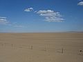
The plains of the Gobi stretch to the horizon

The Trans-Mongolian Railway runs through the Gobi

Sand dunes in the Gobi

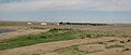
Horses on the northern edge of the Gobi

Yurt in the Gobi
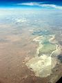
Salt lake in the Gobi
Dal Oasis, Ömnögov-Aimag, Mongolia

Vegetable growing in Dal Oasis, Mongolia

Sand dunes Khongoriin Els (хонгорийн элс) in the Gobi

Gobi near Dunhuang

Remains of the Great Wall of China in the Gobi


documentary
- TV movie Sons of the Desert Part 2: Through the Gobi and Taklamakan . Documentation by Bernd Liebner and Cheng Wie, 2002 (with film recordings by cameraman Paul Lieberenz from the Sino-Swedish expedition ). Also on DVD: Verlag Complete Media, 2003, ISBN 3-8312-8811-9
Web links
- Bjørn Erik Sass: The Great Dune , Time No. 48 from November 22, 2007.
Remarks
- Gobee Desertum
- Gobee
- Kébé (Mongolian)
- Kobi
- Cobi
- Gobi
- Ghobi
- 20th century:
- Говь Gow (in Cyrillic script from 1936 or 1946; introduced into Mongolia under Russian influence)
- Variations of "Shamo" from the 17th century:
- Xamo (1671)
- Variations of "Shamo" from the 18th century:
- Sha-mo
- Chamo
- Zhungar Gobi ( Chinese 准噶尔 戈壁 Zhunga Er Gebi )
- Junggar
- Gurbantünggüt ( Uighur Гурбантүңгүт Қумлуқи )
- Gurbantunggut
- Gurban Tunggut Shamo ( Chinese 古尔 班 通 古特沙 漠 gu er ban tong gu te shamo )
- Gurban Tunggut
- Kurban Tunggut Desert (sandy land)
- Džungarian Gobi
- Djungarian Gobi
- Dzoosotoyn Elisen Desert (Mongolian)
- Dsosotin Eleson;
- Dzosotön Elisun Sands
Individual evidence
- ^ A b c d e f g Troy Sternberg, Henri Rueff, Nick Middleton: Contraction of the Gobi Desert, 2000–2012 . In: Remote Sensing , 7.2, 2015, pp. 1346–1358, mdpi.com (PDF)
- ^ A b John P. Rafferty: Deserts and Steppes. The Rosen Publishing Group, 2011, p. 67 ff. ( Books.google.de )
- ↑ Martino Martini, Imperii Sinarum nova descriptio, 1655 ( Wikimedia file )
- ↑ a b c d e F. Yu et al .: Interannual variations of the grassland boundaries bordering the eastern edges of the Gobi Desert in central Asia. International Journal of Remote Sensing 25.2 (2004), pp. 327–346 ( researchgate.net (PDF) PDF)
- ↑ a b c d e f g Alta S. Walker: Deserts of China: Deserts now make up more than 13 percent of the land area in China, and various methods are being used to transform them into farmland . In: American Scientist , 70.4, 1982, pp. 366-376.
- ↑ a b c d e Xiaoping Yang et al .: The evolution of dry lands in northern China and in the Republic of Mongolia since the Last Glacial Maximum . In: Quaternary international , 118, 2004, pp. 69–85, academia.edu ( page no longer available , search in web archives ) Info: The link was automatically marked as defective. Please check the link according to the instructions and then remove this notice. (PDF)
- ↑ Wang Feng et al .: A Study of Kumtag Desert: Progresses and Achievements . In: Journal of Resources and Ecology , 2.3, 2011, pp. 193–201, jorae.cn (PDF)
- ^ Huixia Chai et al .: Digital regionalization of geomorphology in Xinjiang . In: Journal of Geographical Sciences , May 19, 2009, pp. 600–614, researchgate.net (PDF)
- ↑ a b c d Yen-Huai Liu. A study of the climate of the Gobi Desert in China. (1976) Department of Geography, NTNU ( online ) ( PDF , 2.73 MB)
- ↑ D. Cover et al .: OSL dating of sediments from the Gobi desert, Southern Mongolia . In: Quaternary Geochronology , 5.2, 2010, pp. 107–113, researchgate.net (PDF)
- ^ Zhu Jinfeng et al .: Study on the boundary and the area of Badain Jaran Desert based on remote sensing imagery . In: Progress in Geography , 29.9, 2010, pp. 1087-1094, progressingeography.com (PDF; 1.6 MB)
- ↑ Xiaoping Yang et al .: Recharge to the inter-dune lakes and Holocene climatic changes in the Badain Jaran Desert, western China . In: Quaternary Research , 73.1, 2010, pp. 10–19, cge.ac.cn (PDF)
- ↑ a b c d e f g h i j Haijing Tian et al .: Response of vegetation activity dynamic to climatic change and ecological restoration programs in Inner Mongolia from 2000 to 2012 . In: Ecological Engineering , 82, 2015, pp. 276–289, ai2-s2-pdfs.s3.amazonaws.com (PDF)
- ↑ Wenbo Rao et al .: Sr-Nd isotopic characteristics of eolian deposits in the Erdos Desert and Chinese Loess Plateau: Implications for their provenances . In: Geochemical Journal , 42.3, 2008, pp. 273–282, jstage.jst.go.jp (PDF)
- ↑ Yang Guang, Li Qinghe: Spectral characteristics of artificial biological crust of desert alga in the east edge of Kubuqi Desert . In: Science of Soil and Water Conservation , 12.1, 2014, pp. 90-95 (Chinese), sswcc.com.cn (PDF)
- ↑ a b c Huayu Lu et al .: Late Quaternary aeolian activity in the Mu Us and Otindag dune fields (north China) and lagged response to insolation forcing . In: Geophysical Research Letters , 32.21, 2005, doi: 10.1029 / 2005GL024560 )
- ↑ YAN Yan, Jiao-jun Zhu, Qiao-ling Yan et al .: Demarcation of the Horqin Sandy Land Boundary Based on Remote Sensing and GIS Technique . In: Scientia Geographica Sinica , 2014, 34 (1), pp. 122–128 ( geoscien.neigae.ac.cn )
- ↑ Zuo, Xiaoan, et al .: Spatial heterogeneity of soil properties and vegetation – soil relationships following vegetation restoration of mobile dunes in Horqin Sandy Land, Northern China. Plant and soil 318.1-2 (2009): 153-167. doi : 10.1007 / s11104-008-9826-7 ( researchgate.net PDF)
- ↑ Jo Schwarz: The Badan Jilin desert is still a real adventure . ( Memento of the original from January 1, 2013 in the Internet Archive ) Info: The archive link was inserted automatically and has not yet been checked. Please check the original and archive link according to the instructions and then remove this notice. Adventure China, November 9, 2011
- ↑ China extreme - the Badan Jilin desert in Inner Mongolia . ( Memento of the original from October 29, 2013 in the Internet Archive ) Info: The archive link was inserted automatically and has not yet been checked. Please check the original and archive link according to the instructions and then remove this notice. Kaiyuan Information & Business, November 9, 2011
- ↑ Jo Schwarz: HDR photos and panoramas of the Badan Jilin desert . ( Memento of the original from October 29, 2013 in the Internet Archive ) Info: The archive link was inserted automatically and has not yet been checked. Please check the original and archive link according to the instructions and then remove this notice. black, November 9, 2011
- ↑ B. Laurent et al .: Modeling mineral dust emissions from Chinese and Mongolian deserts . In: Planetary Change , 52.1, 2006, pp. 121–141, citeseerx.ist.psu.edu (PDF)
- ↑ Marco Polo: The Travels of Marco Polo, the Venetian: the translation of Marsden revised, with a selection of his notes. Henry G. Bohn, 1854. ( books.google.de )
- ↑ Jie Xuan et al .: Identification and characterization of sources of atmospheric mineral dust in East Asia. In: Atmospheric Environment , 38.36, 2004, pp. 6239–6252, kenrahn.com (PDF)
- ↑ a b c d e Histoire générale de la Chine ou annales de cet empire . Volume 12. Pierres, 1783, ( books.google.de )
- ^ A b c Thomas Astley: A New General Collection of Voyages and Travels. Volume 4. London 1747. ( books.google.de )
- ↑ George L. Trager, John G. Mutziger: The Linguistic Structure of Mongolian Placenames. Journal of the American Oriental Society 67.3 (1947), pp. 184-195. ( documents.tips , download)
- ↑ Davaadulam Davaakhuu: Mongolian Named Entity Recognition. Istanbul 2012, ( davaa.files.wordpress.com (PDF)
- ↑ Marco Polo: Marci Pauli Veneti, Historici fidelissimi iuxta ac praestantissimi, De Regionibus Orientalibus: Libri III .; Cum Codice Manuscripto Bibliothecae Electoralis Brandenburgicae collati, exq [ue] eo adiectis Notis plurimum tum suppleti tum illustrati. Coloniae Brandenburgicae, Schulzius, 1671. ( digitized version )
- ^ Dimitri Saint-Carlier: Evolution tectonique du Tianshan oriental du Néogène à l'actuel. docnum.univ-lorraine.fr (PDF)
- ^ Jürgen Utrata: Utrata specialist dictionary: Geography - English-German / German-English. Utrata Fachbuchverlag, 2014, books.google.de