Dunhuang
Dunhuang ( 敦煌 市 , Dūnhuáng Shì ) is an old oasis town on the Silk Road in the northwest of the western Chinese province of Gansu . As an independent city, it belongs to the administrative area of the independent city of Jiuquan . It administers a territory of 31,200 square kilometers. In 2013, Dunhuang had 140,000 residents. Dunhuang's neighbors are Guazhou in the northeast, Subei in the southeast, Aksay in the south and Xinjiang in the west.
geography
location
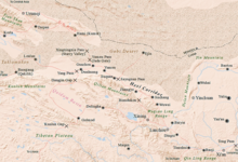
Dunhuang is located at the west end of the Hexi Corridor in the middle of desert areas . In the south of the territory of Dunhuang are the Qilian Shan Mountains, in the north the Mazong Shan Mountains, in the west and east the Gobi Desert . The relief is mountainous in the north and south, from west to east it forms a gently sloping plain with an average height of 1139 m.
Not far from the city to the west, the Silk Road divides into its northern and southern branches to bypass the Taklamakan desert . The Yangguan , an important pass, is also located here.
Dunhuang has an arid continental desert climate.
Administrative structure
At the municipality level, the administrative area is made up of nine large municipalities . These are:
- Greater community Shazhou (沙州镇), center, seat of the city government;
- Greater Qili Community (七里 镇);
- Greater community Suzhou (肃州镇);
- Mogao Municipality (莫 高 镇);
- Greater community Yangguan (阳关镇);
- Greater community Guojiabu (郭家堡乡);
- Greater community Yueya Quan (月牙泉镇);
- Greater community Zhuanqukou (转渠口镇);
- Greater community Huangqu (黄渠镇).
population
The census in 2000 counted 187,578 people in Dunhuang (population density 6.96 inhabitants / km²).
| Name of the people | Residents | proportion of |
|---|---|---|
| Han | 183,616 | 97.89% |
| Hui | 2,556 | 1.36% |
| Do | 297 | 0.16% |
| Tibetans | 295 | 0.16% |
| Mongols | 186 | 0.1% |
| Manchu | 172 | 0.09% |
| Dongxiang | 98 | 0.05% |
| Tujia | 76 | 0.04% |
| Miao | 73 | 0.04% |
| Uighurs | 59 | 0.03% |
| Salar | 31 | 0.02% |
| Korean | 21st | 0.01% |
| Others | 98 | 0.05% |
history
As early as 111 BC BC Dunhuang was founded by the emperor Wudi of the western Han dynasty . Due to its location on the old Silk Road , it played an important role as the most important Chinese hub on this trade route in the exchange of culture and goods with the West. This is how Buddhism spread from Dunhuang to China. The construction of the Mogao caves began in 366 and continued into the 14th century.
In 787 the Tibetans captured Dunhuang. After the collapse of the Tibetan Empire, the Tibetans withdrew from their possessions in Gansu and East Turkistan, and the independent "State of Guiyijun" (Kuei i-chün) was established in Dunhuang, which existed from 848 to the 890s.
Attractions
- The Buddhist Mogao grottoes are 25 km southeast of Dunhuang ; numerous other cave temples are grouped under the name Dunhuang grottoes .
- about 5 km south is an area with up to 300 m high reverberant sand dunes ( Mingsha Shan );
- and in front of it the Yueya Quan ("crescent moon lake", literally "crescent moon spring"), a waterhole that appears threatened by the sand.
- Sections of the Great Wall of China from the Han Dynasty and the Fengsui ruin
literature
- Dunhuang Institute of Cultural Relics (Ed.): The Dunhuang Cave Temples. A millennium of Chinese art . Stuttgart: Klett-Cotta 1982.
- Jürgen Paul : Central Asia. S. Fischer, Frankfurt am Main 2012 ( New Fischer World History , Volume 10).
Web links
- The International Dunhuang Project
- International Dunhuang Project (English)
- Dunhuang Studies
- Entry in the Encyclopædia Iranica
Individual evidence
- ↑ a b c d 敦煌 市 概况 地图.行政 区划 网, June 27, 2016, accessed on August 9, 2018 (Chinese).
- ↑ J. Paul: Zentralasien, p. 139
- ↑ Presentation on studyBuddhism, accessed on June 29, 2020
Coordinates: 40 ° 8 ' N , 94 ° 39' E


