Qilian Shan
| Qilian Shan | |
|---|---|
|
Qilian high mountains |
|
| Highest peak | Tuanjie ( 5826.8 m ) |
| location | Provinces Gansu and Qinghai ; PR China ( Asia ) |
| part of | Nan Shan |
| Coordinates | 38 ° 45 ′ N , 98 ° 45 ′ E |
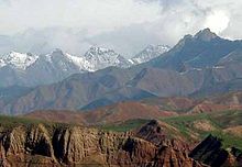
Qilian Shan ( Chinese 祁連山 / 祁连山, Pinyin Qílián Shān ) is a high mountain range up to 5826.8 m in the provinces of Gansu and Qinghai in the west of the People's Republic of China ( Asia ).
The mountain range was formerly called the Richthofen Mountains - in honor of the German explorer and geographer Ferdinand von Richthofen , who made long exploratory trips through China in the 1860s to explore coal deposits.
Geographical location
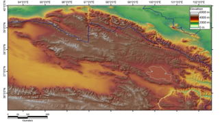
The Qilian Shan is the eastern main part of the Nan Shan mountain range and contains its highest mountain. It rises about 4500 m above the oases to the north and up to the maximum height of 5826.8 m . It begins at the eastern end of the Allyn-tag at about 96 ° east longitude and extends, trending south-east on average, through nine degrees of longitude to the area of Lanzhou . The drop to the north is imposing, but less significant to the south, because there the valleys of the Nan Shan already have heights of 3000 to 4000 meters above sea level. The mountain range consists of several longitudinal ranges, which are formed from densely packed folds of paleozoic strata. The eastern part of the Kunlun Mountains extends south of the Qilian Shan . There is the Qinghai Lake . The Gobi desert spreads to the north . The western main part of the Nanshan joins the Altun Mountains to the west .
Partial mountain ranges
The sub-mountains of the Qilian Shan include:
- Ulan Daban Shan (乌兰 大 坂 山), sometimes also "Danghe Nanshan" (党 河南 山), formerly called "Humboldt Chain",
- Mahai Daban Shan (马海 大 坂 山),
- Daken Daban Shan (达肯 大 坂 山), formerly called "Knight Mountains",
- Zhongwunong Shan (和 中 吾 农 山).


