Kunlun
| Kunlun Mountains 昆仑 山脉 |
||
|---|---|---|
|
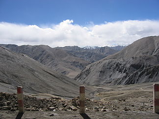
Western Kunlun Shan; seen from the Tibet-Xinjiang road |
||
| Highest peak | Liushi Shan ( 7167 m ) | |
| location | Xinjiang , Tibet , Qinghai ( PR China ) | |
|
|
||
| Coordinates | 36 ° 0 ′ N , 84 ° 0 ′ E | |
Kunlun , outdated: Kuenlun , ( Chinese 崑崙 山脈 / 昆仑 山脉 , Pinyin Kūnlún Shānmài - "Kunlun Mountains", short 崑崙 山 / 昆仑 山 , Kūnlún Shān , Tib. ཁུ་ ནུ་ རི་ རྒྱུད) is almost 3000 km long and up to 7167 m high mountain range in China ( Asia ).
geography
The high mountains run from the Yarkant River , which forms the natural border to the Pamir , and from the Karakorum Pass ( 5575 m ), which defines the boundary to the Karakoram , along the northern border with the Tibet Autonomous Region of the People's Republic of China to the east. It forms the border with the highlands of Tibet for about 2500 km , the remaining eastern part is in the Uyghur Autonomous Region of Xinjiang .
The Kunlun Mountains essentially consist of the western Przhevalsky Mountains , which meet the northern edge of the Tibetan Plateau, and the eastern Marco Polo Mountains , which border the same highlands and meet the southern edge of the Qaidam Basin . The Nan Shan branches off from the Prschewalski Mountains towards the northeast . The eastern continuation is known as the Qinling Shan .
mountains
The mountain ranges of the Kunlun Shan have over 200 peaks of over 6000 m height. The mountains include:
- Liushi Shan ( Kunlun Goddess ) ( 7167 m , ⊙ )
- Ulugh Muztagh ( 6973 m , ⊙ )
- Bukadabang Feng ( 6860 m , ⊙ )
- Yurung Shan I ( 6778 m , ⊙ )
- Yurung Shan II ( 6767 m , ⊙ )
- Kotaklik Shan ( 6580 m , ⊙ )
- Yuzhu Shan ( 6178 m , ⊙ )
- Malan ( 6056 m )
- Tekiliktag ( 5466 m )
![]() Map with all coordinates of the mountains section : OSM
Map with all coordinates of the mountains section : OSM
Geological history
The Kunlun Mountains were created when the plate of the Indian subcontinent collided with the Eurasian plate , thereby closing the primordial ocean known as Tethys .
The mountain range, rich in natural resources, is largely a high mountain desert.
mythology
The mountains are also known as Daoist paradise in Chinese mythology . According to legend, the first traditional journey there was made by King Mu Wang (1001 to 946 BC) from the Zhou dynasty . There he allegedly discovered the Jade Palace of Huáng Dì , the mythical Yellow Emperor, and met Xiwangmu , the royal mother of the West , who also had her mythological abode there. The Kunlun Mountains were therefore seen as the place where one could attain immortality. According to mythology, the Xian , the immortals , lived here .
Inspired by this legend, the British writer James Hilton relocated the fictional location of Shangri-La to the western end of the Kunlun Mountains in his 1933 novel Lost Horizon . Hilton's utopia was so successful that many believe in the existence of Shangri-Las to this day and go in search of the mystical place in the Kulun.
European research
In 1855 the Bavarian Alpine explorers Hermann Schlagintweit and his brother Robert Schlagintweit crossed the Kunlun Mountains. After his elevation to the hereditary Bavarian nobility, Hermann von Schlagintweit added the name of the mountain to his family name in the form of Schlagintweit-Sakünlünski .
literature
- Josef Guter: Lexicon of the gods and symbols of the ancient Chinese. Marix, Wiesbaden 2004, ISBN 3-937715-04-5 , p. 199
Web links
- Kunlun Shan (English)
- Enciclopedia Britannica: Kunlun Mountains (English)
- Article Kunlun in the Great Soviet Encyclopedia (BSE) , 3rd edition 1969–1978 (Russian)
- Video: Landscape development of extreme high mountains - Karakoram and Kuenlun . Institute for Scientific Film (IWF) 1999, made available by the Technical Information Library (TIB), doi : 10.3203 / IWF / C-2017 .
Individual evidence
- ↑ Aboutbooks: The Lost Horizon by James Hilton. In: lovelybooks.de, accessed on October 29, 2018
- ^ Claudia Frickel: Mystery. The hidden paradise of Shangri-La . Web.de-Magazin, June 7, 2017. In: web.de Magazine, accessed on October 31, 2018
- ↑ Michael McRae: The Siege of Shangri-La. The Quest for Tibet's Sacred Hidden Paradise. Broadway Books, 2002.


