Qin Ling
|
Qin-Ling 秦岭 |
|
|---|---|
|
Location of the Qin Ling between the two major river systems in China |
|
|
Taibai Shan - 太白 山 |
|
| Highest peak | Taibai Shan ( 3767 m ) |
| location |
Gansu , Henan , Shaanxi ( PR China ) |
| Coordinates | 33 ° 58 ' N , 107 ° 37' E |
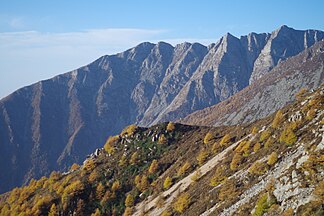
The Qin Ling ( Chinese 秦嶺 / 秦岭 , Pinyin Qín Lǐng ), also called the Qin Ling mountain range ( 秦嶺 山脈 / 秦岭 山脉 , Qín Lǐng Shānmài ), geographically in the center of the People's Republic of China , extends in a west-east direction over about 1000 km in length (with a width of up to 170 km) from the south of Gansu Province over the entire south of Shaanxi Province to the central part of Henan Province .
The Taibai Shan is the highest mountain of the Qin Ling with 3767 m . In the north the mountains are bordered by the Wei River and in the south by the Han Jiang River . These two rivers drain into the two great Chinese rivers.
The mountains not only form a watershed between the river systems of the Yellow River and the Yangtze River , but also a distinctive vegetation boundary . While dry loess regions predominate north of the mountain range , which are ideally suited for wheat cultivation , the warmer, moister regions begin south of the Qin Ling, in which extensive forest regions alternate with rice fields .
Mountains (selection)
Below are a number of peaks along the main ridge of the Qin Ling, sorted from west to east:
![]() Map with all coordinates: OSM | WikiMap
Map with all coordinates: OSM | WikiMap
- Taibai Shan ( 3767 m ) ( ⊙ ), Shaanxi
- Hua Shan ( 2155 m ) ( ⊙ ), Shaanxi
Individual evidence
- ↑ Article Qin Ling in the Great Soviet Encyclopedia (BSE) , 3rd edition 1969–1978 (Russian)

