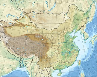
Hunshandak desert
| Hunshandake sandland
浑善达克 沙地
|
||
|---|---|---|
| location |
Inner Mongolia |
|
| part of | Gobi desert | |
|
|
||
| Coordinates | 43 ° 0 ′ N , 115 ° 0 ′ E | |
| rock | Sand dunes | |
| surface | (1,970) 20,850 km 2 .
(1,980) 23,200 km 2 . |
|
The Hunshandak Desert or Hunshandake Desert ( Chinese 混 善 达克 沙漠 , Pinyin Hunshandake Shamo or 混 善 达克沙 地 , Hunshandake Shadi ), also known as the Little Tengger Desert ( 小 腾 格里 沙漠 , Xiao Tenggeli Shamo ), is a desert in the south of the Xilin Gol Federation of the Inner Mongolia Autonomous Region in the People's Republic of China , about 180 km from Beijing. As part of an environmental protection program, a four hundred kilometer long and one to ten kilometer wide strip of trees, bushes and grass has been created on the southern edge of the desert.
See also
Web links
Individual evidence
- ↑ Jin, HeLing, LiangYing Sun, and Zhong Sun. "Millennial-scale evolution of Hunshandake Desert and climate change during the Holocene in Inner Mongolia, northern China." Sciences in Cold and Arid Regions 2.6 (2010): 505-513. ( PDF )
- ↑ a b c Kang, Xiang-wu1, et al. "Research on Spatio-Temporal Change of Sandy Desertification in Hunshandake." Journal of Soil and Water Conservation 23.1 (2009): 1-6. ( PDF )
- ↑ 丁国栋, et al. "浑善达克 沙地 草场 资源 评价 与 载畜量 研究." 生态学 杂志 24.9 (2005): 1038-1042. ( PDF )
- ↑ Gong, Zhijun, et al. "Environmental changes in Hunshandake (Otindag) sandy land revealed by optical dating and multi-proxy study of dune sands." Journal of Asian Earth Sciences 76 (2013): 30-36. ( PDF )
- ↑ http://german.cri.cn/401/2008/04/22/[email protected]

