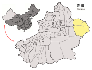
Cumul
| Basic data | |
|---|---|
| Greater Region: | Northwest China |
| Autonomous area : | Xinjiang |
| Status: | Administrative district |
| Residents : | 492.096 |
| Area : | 85,035 km² |

|
|
Kumul (Chin. Hami ) is a Chinese administrative district in the Uyghur Autonomous Region of Xinjiang . Its capital, the independent city of Kumul (Hami), is an oasis. Throughout China, Kumul / Hami is best known for its melons.
Geography and climate
Some parts of the area are up to 150 meters below sea level. The mountains of the eastern Tian-Shan rise in the group of the Qarlik Taghs to over 4900 m. There are extreme temperature fluctuations, from 43 ° C in summer to −32 ° C in winter. The administrative district has a total area of 140,749 km².
| Cumul | ||||||||||||||||||||||||||||||||||||||||||||||||
|---|---|---|---|---|---|---|---|---|---|---|---|---|---|---|---|---|---|---|---|---|---|---|---|---|---|---|---|---|---|---|---|---|---|---|---|---|---|---|---|---|---|---|---|---|---|---|---|---|
| Climate diagram | ||||||||||||||||||||||||||||||||||||||||||||||||
| ||||||||||||||||||||||||||||||||||||||||||||||||
|
Average monthly temperatures and precipitation for cumulative
Source: wetterkontor.de
|
|||||||||||||||||||||||||||||||||||||||||||||||||||||||||||||||||||||||||||||||||||||||||||||||||||||||||||||||||||||||||||||||||||||||
Administrative structure
The administrative district consists of a city, a district and an autonomous district:
- District of Yizhou (伊州 区 Yīzhōu Qū, formerly 哈密 市 Hāmì Shì), 85,035 km²,
- Araturük District (伊吾 县 Yīwú Xiàn), capital: Yiwu Municipality (伊吾 镇), 20,000 km²,
- Kazakh Autonomous District of Barkol (巴里坤 哈萨克 自治县 Bālǐkūn Hāsàkè zìzhìxiàn), capital: Barkol municipality (巴里坤 镇), 35,714 km².
Names
| Uighur name | |
|---|---|
| Arabic-Persian (Kona Yeziⱪ) : | قۇمۇل ۋىلايىتى |
| Latin (Yengi Yeziⱪ) : | Ⱪumul Wilayiti |
| official notation ( PRCh ): | Cumul |
| Pronunciation in IPA : | [ qumuɫ ] |
| other spellings: | Qumul |
| Chinese name | |
| Abbreviation : | 哈密 地区 |
| Traditional characters : | 哈密 地區 |
| Transcription in Pinyin : | Hāmì Dìqū |
| Wade-Giles transcription : | Ha-mi Ti-ch'ü |
The place is called Ⱪumul in Uighur . The Jesuits Benedict Goës and Matteo Ricci , who toured China, described the oasis in 1615 as "Camul". One of the oldest Chinese names (2nd century C.E. ) is Kūnmò昆莫; during the Han dynasty it was also called Yīwú伊吾 or Yīwúlú伊吾 卢, during the Tang dynasty Yīzhōu伊州; During the Yuan Dynasty , the Mongolian name Qamil was transcribed into Chinese as Hāmìlì哈密 力, and Kumul has been known as Hāmì哈密since the Ming Dynasty .
history
The city of Hami was ruled by the Djungarian Khanate in the 17th century , and in 1697 it was conquered by the Qing dynasty .
The existing local rule remained as a semi-autonomous khanate in 1759 . When this situation came to an end, Dungan and Uyghur uprisings broke out in April 1931 and were suppressed in November.
Ethnic breakdown of the population of the Kumul administrative district (2000)
According to the 2000 census, the administrative district had 492,096 inhabitants (population density: 3.5 inhabitants / km²).
| Name of the people | Residents | proportion of |
|---|---|---|
| Han | 339.296 | 68.95% |
| Uighurs | 90,624 | 18.42% |
| Kazakhs | 43.104 | 8.76% |
| Hui | 14,636 | 2.97% |
| Mongols | 1,970 | 0.4% |
| Manchu | 1,293 | 0.26% |
| Tibetans | 191 | 0.04% |
| Do | 142 | 0.03% |
| Dongxiang | 121 | 0.03% |
| Zhuang | 119 | 0.02% |
| Tujia | 110 | 0.02% |
| Xibe | 101 | 0.02% |
| Russians | 77 | 0.02% |
| Yugur | 73 | 0.01% |
| Others | 239 | 0.05% |
By the end of 2002 the population had risen to around 519,700.
Web links
- hmnet.gov.cn Chinese government website on Kumul (in Chinese)
- hami.gov.cn Chinese government website on Kumul (in Chinese)
Individual evidence
- ^ Jürgen Paul : Central Asia. S. Fischer, Frankfurt am Main 2012 ( Neue Fischer Weltgeschichte , Volume 10), p. 158.
- ^ Jürgen Paul : Central Asia. S. Fischer, Frankfurt am Main 2012 ( Neue Fischer Weltgeschichte , Volume 10), p. 416.
Coordinates: 42 ° 50 ' N , 93 ° 30' E