Tumxuk
| Basic data | |
|---|---|
| Greater Region: | Northwest China |
| Autonomous area : | Xinjiang |
| Status: | District-free city |
| Residents : | 150,000 |
| Area : | 1,901 km² |

|
|
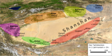
Tumxuk or Tumschuk ( Chinese 图 木 舒克 市 , Pinyin Túmùshūkè Shì ; Uighur تۇمشۇق شەھىرى, Tumxuⱪ Xəⱨiri ; Occasionally also called Tumšuq , Tumushuk and Tumshuq ) is an independent city in the west of the Uyghur Autonomous Region of Xinjiang in the People's Republic of China, which is directly subordinate to the regional government (and not like other independent cities at the district level) . It is located in the west of the Tarim Basin and in the east of the surrounding administrative district of Kashgar . The administrative area of the city has an area of 1,901 square kilometers and a population of 150,000 (2005).
Administrative structure
At the community level, Tumxuk consists of three street districts , a large community and five production and construction corps. These are:
- Qianhai Street District (前 海 街道);
- Xiyganqol Street District (齐 干 却 勒 街道);
- Yong'anba Street District (永安 坝 街道);
- Greater community Karabel (喀拉拜勒镇);
- Production and Reconstruction Corps No. 44 (兵团 四 十四 团);
- Production and Reconstruction Corps No. 49 (兵团 四 十九 团);
- Production and Reconstruction Corps No. 50 (兵团 五十 团);
- Production and Reconstruction Corps No. 51 (兵团 五十 一 团);
- Production and Reconstruction Corps No. 53 (兵团 五十 三 团).
See also
Footnotes
- ↑ The official spelling is "Tumxuk", see Zhōngguó dìmínglù中国 地 名录 (Beijing, Zhōngguó dìtú chūbǎnshè中国 地图 出版社 1997); ISBN 7-5031-1718-4 ; P. 312.
Coordinates: 39 ° 52 ' N , 79 ° 4' E

