Pamir Highway


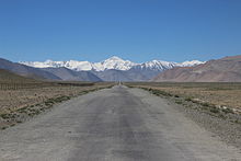
The Pamir Highway ( Russian Памирский тракт Pamirski trakt , German Pamirstrasse), officially a section of the M41 trunk road , is the main thoroughfare of the Pamir Mountains in Central Asia . It is the only connecting road through the eastern Tajik region of Berg-Badachschan and, after the Karakoram Highway, the second highest paved highway in the world.
Route
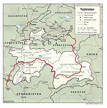
The Pamir Highway connects over a distance of 1,252 km, the Kyrgyz city of Osh with the Tajik region Gorno-Badakhshan located khorugh or the Tajik capital Dushanbe . In northeast Tajikistan, the highway crosses the Ak-Baital Pass (4655 meters) at its highest point . Then the Pamir Highway passes the Karakul before crossing the border to Kyrgyzstan at the Kyzyl Art Pass at an altitude of 4282 meters . Here the Pamir Highway leaves the Pamir Mountains northwards and passes through the Trans-Alai or Alai Mountains . The Kyrgyz city of Osh marks the end of the Pamir Highway.
The Pamir Highway itself is almost entirely paved, albeit in poor condition. Entire stretches of road were washed away by floods ; repairs were only provisional, if at all, and the river in question often had to be crossed. Rock falls and rockfalls blocking parts of the road are common. In some places the asphalt pavement of the road is so battered that these sections are being abandoned in favor of more easily navigable, unpaved roads right next to the Pamir Highway. Supply trips in the East Pamir often take place from the Kyrgyz Osh, as the selection of goods in this big city is much more diverse than in the nearby Chorugh and the road to Dushanbe is too poor.
The route in East Pamir, which is never below 3500 meters, is characterized by a high mountain desert with little rainfall during the year. The valleys here are very wide and extensive. There are only a few places along the approximately 500-kilometer stretch between Chorugh in Tajikistan and Sarytasch in Kyrgyzstan (including Alichur , Murgab , Karakul ). If the view is clear, u. a. to see the peaks of Lenin Peak (7134 meters) and Muztagata (7509 meters). The route profile in West Pamir differs from that in East Pamir in that the road west of Chorugh along the Pyanj runs in a much narrower and steeper valley and the rainfall is also significantly higher.
history
After the founding of the Tajik Soviet Socialist Republic in 1929, construction of the Pamir Highway began shortly thereafter. The construction of the section between Osh and Chorugh, which was already completed in 1932, resulted in a fundamental transformation of the Berg-Badachschans region , as this previously extremely remote area was now connected to the Soviet road network. The Soviets celebrated the Pamir Highway as a structural and ideological masterpiece. Construction projects of a similar dimension (e.g. the Karakoram Highway ) were otherwise only started two to three decades later. The section of road between Chorugh and Dushanbe was completed in 1940. While the Pamir Highway was officially referred to as the Pamirskii trakt in the Soviet Union , it is often referred to simply as the road by the local population ( Tajik raw , Kyrgyz dshol , Russian doroga ).
The construction of the connecting road between Osh and Chorugh made it possible for the first time to easily penetrate today's Murgab district , whose desert-like high plateaus were hardly populated before the 1930s. Due to the extremely difficult climatic conditions (including the high altitude, very low winter temperatures, avalanches), the road must be continuously maintained. For this reason, some settlements arose along the road in the course of the 20th century, which on the one hand offered the possibility of car repairs, on the other hand also hid vehicles for the maintenance of the Pamir Highway.
Although there was a significant history of crossing the East Pamir (connection to the Silk Road ) long before the Pamir Highway was built, it was only the paved road that made permanent settlement structures possible in the Murgab district. At the end of the 19th century, Russia built a garrison ( Pamirskii Post ) on the site of today's city of Murgab, which grew rapidly in terms of population with the construction of the highway as a supply and supply center. Today Murgab is the administrative center of the district with about 7000 inhabitants.
There are still some checkpoints along the Pamir Highway , including a. also to combat drug smuggling from Afghanistan , which increased sharply , especially after the departure of the Russian border troops in 2004. In addition, areas off the Pamir Highway between Chorugh and Dushanbe and along the Afghan border are mined . Since 2002, a joint initiative of the OSCE and the FSD has been trying to clear the remains of these mines that were scattered during the Tajik civil war . Today the Pamir Highway is a popular travel destination for foreign cyclists and motorcyclists. In addition to the regular visa for Tajikistan, a special permit for the autonomous province of Berg-Badachschan is required to drive on the Pamir Highway , which can also be applied for at the embassy.
Web links
- The Pamir Highway: route profile and information (German)
- Current travel information about the Pamir (English)
Individual evidence
- ↑ a b c d e Tajikistan’s Pamir Highway: A Decaying Lifeline to the East on eurasianet.org . Retrieved August 26, 2012
- ^ Hermann Kreutzmann (2004): Accessibility for High Asia: Comparative perspectives on northern Pakistan's traffic infrastructure and linkages with its neighbors in the Hindukush-Karakoram-Himalaya In: Journal of Mountain Science, Vol. 1, 3rd pp. 193-210. doi : 10.1007 / BF02919325
- ↑ a b c Till Mostowlansky (2011): Paving the Way: Ismaʿili Genealogy and Mobility along Tajikistan's Pamir Highway In: Journal of Persianate Studies , 4. pp. 171-188. doi : 10.1163 / 187471611X600378
- ↑ Bloody settlements in the Pamir on nzz.ch . Retrieved August 28, 2012.
- ↑ Information from the Austrian Foreign Ministry for Travel to Tajikistan. Accessed on August 28, 2012.
- ^ Towards a mine-free Tajikistan on osce.org . Retrieved August 28, 2012.
- ^ Pamir Mountains, the Crossroads of History on nytimes.com . Retrieved August 26, 2012
- ↑ Travel regulations for the Republic of Tajikistan ( Memento of the original from June 29, 2012 in the Internet Archive ) Info: The archive link was inserted automatically and has not yet been checked. Please check the original and archive link according to the instructions and then remove this notice. Point 5: Free movement of foreign tourists on the territory of the Republic of Tajikistan (homepage of the Tajik embassy in Germany). Retrieved August 26, 2012


