Muztagata
| Muztagata | ||
|---|---|---|
|
Muztagata |
||
| height | 7509 m | |
| location | Xinjiang ( PR China ) | |
| Mountains | Pamir | |
| Dominance | 38.42 km → Kongur Jiubie | |
| Notch height | 2735 m ↓ (4811 m) | |
| Coordinates | 38 ° 16 '33 " N , 75 ° 6' 58" E | |
|
|
||
| rock | predominantly granite - gneiss | |
| Age of the rock |
Protolith : Triassic metamorphosis : Jurassic |
|
| First ascent | probably 1956 by Qu Yinhua , Vitali Abalakow and others | |
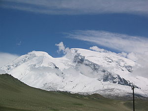
The Muztagata is the third highest peak of the Pamir Mountains in the People's Republic of China with a height of 7509 m .
Surname
The name "Muztagata" (also Mustagh Ata, Mouztagh-ata or Muz Tagh Ata) is of Uighur origin and means something like "father of the icebergs". The Uighur spelling is Arabic مۇز تاغ ئاتا Muz Tagh Ata , the Chinese name is 慕士塔格 峰 Mùshìtǎgé Fēng .
geography
The Muztagata is located in the eastern part of the Pamir Mountains, in the west of the Uyghur Autonomous Region Xinjiang of the People's Republic of China , about 150 km southwest of Kashgar and only about 30 km east of the Chinese- Tajik border, beyond this, among other things, the famous Pamir peaks of Pik Tower Ismoil Somoni and Lenin Peak. Together with the Kongur ( 7649 m ), it towers over the Taklamakan desert, visible from afar .
geology
The Muztagata massif is part of the Sares Muztagata dome structure, which is one of several gneiss domes of the metamorphic core of the Pamir part orogens . The dome structure is located on the lying floe of the Kongur-Shan Deportation , a geologically very recent main fault in the eastern Pamir, the outcrop line of which surrounds the Muztagata massif in the north, west and south.
The massif is essentially made up of two units: an orthogneiss unit, which emerged from Triassic granites , and its Ordovician slate shell . The latter is only preserved on the western flank of the mountain. The gneiss shows pronounced bands of layers that are particularly rich in quartz and feldspar ( plagioclase , potassium feldspar ) and dark layers that are rich in biotite and hornblende . The rocks of the slate shell consist of an alternating layer of amphibolite facial metapelites , metabasites as well as marble and calcareous silicate rocks . The metapelites show clear migmatization in the lower part of the sequence , which is due to the partial melting of the rock as a result of the drainage of muscovite during the metamorphosis.
The Orthogneiss unit is the permo Triassic Muztagata-Caracul volcanic arc attributed to that builds a large part of the northeastern Pamir Mountains. The metasediments of Schieferhülle as part of the Paleozoic basement of Zentralpamir- Terrans interpreted that the Muztagata-Karakul Arc after closure of the Paleo-Tethys -Beckens in the early Jurassic ran over , which in turn the metamorphosis of metasediments and gneisses in about 35 km Crust depth resulted. The contact area of the slate shell and the gneiss core corresponds to a suture between two different crust blocks.
The exhumation (ascent to the surface) of these rocks with the formation of the dome structure finally took place in the Miocene and Pliocene , due to continued crust shortening in the region in the course of the collision of the Indian plate with Asia.
Rockclimbing
General
Mountaineers rate the Muztagata as technically rather easy, but physically very demanding due to the altitude. It is one of the most popular expedition mountains in the world. Its even flanks predestine it for an ascent with touring skis or snowshoes .
First ascent
In 1956 the Muztagata is said to have been climbed for the first time by a Russian-Chinese rope team (including Witali Michailowitsch Abalakow , Qu Yinhua ).
Quote
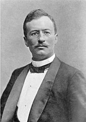
In his first expedition 1893 bis 1897 succeeded Sven Hedin in 1894 not to climb the Muztagata. From his high altitude camp at 6300 m he had a unique view of the 7509 m high Muztagata:
“The sun went down and its purple glow went out on the western slopes of Muztagata. As the full moon rose over the pinnacle of the rock face on the south side of the glacier, I stepped out into the night to admire one of the greatest spectacles I have ever seen in Asia.
The eternal snow fields on the highest crest of the mountain, the firn basin that feeds the glacier, and its highest regions bathed in the silver glow of the moon, but where the ice flow lay in its deep rock channel, dark, unfathomable shadows reigned over the arched snow fields Clouds, and you thought you could see the spirits of the mountain dancing in the open air. I stood as high as the summit of Chimborazo or Mount McKinley and higher than Kilimanjaro , Montblanc and all the peaks of three continents; only the highest peaks in Asia and the Andes were higher. To the top of the highest mountain on earth, Mount Everest , 2600 m were still missing . But I still believe that the picture that unfolded in front of me surpassed everything in wild, fantastic beauty that a mortal can see on earth. "
Speed records
On August 23, 2005, the two young Munich extreme ski mountaineers Benedikt Böhm and Sebastian Haag set a record for climbing Muztagata and then skiing. As participants in an expedition led by the internationally renowned high-altitude mountaineer Matthias Robl , they started their attempt to climb from the base camp at 4450 m at 4 a.m. The originally planned Spaniard Javier Martín de Villa could not take part in the tour due to illness. At temperatures down to minus 35 ° C, the athletes reached the summit at 1:25 p.m. After the subsequent departure, they were back at the base camp at 2:41 pm.
On August 10, 2007, Matthias Robl improved the record to 9:37 hours.
Markus Amon succeeded in further improving the record on August 12, 2009. He started from base camp at 4 am. Passing the high camps, he reached the summit at 12:50 after a solo speed ascent. The ascent time was 8 hours and 50 minutes. The subsequent descent and descent get back to the base camp in the best conditions. A week earlier, on August 5, 2009, he was able to reach the summit from camp 1 ( 5520 m ) in 5 hours and then also descend to base camp.
Web links
- Muztagata on Peakbagger.com (English)
- Muztagh Ata at Peakware (English)
- Photo at caingram.info
- Muztagh Ata at summitpostorg
Individual evidence
- ↑ a b c Alexander C. Robinson, Mihai Ducea, Thomas J. Lapen: Detrital zircon and isotopic constraints on the crustal architecture and tectonic evolution of the northeastern Pamir. Tectonics. Vol. 31, No. 2, 2012, TC2016, doi: 10.1029 / 2011TC003013 .
- ↑ Alexander C. Robinson, An Yin, Craig E. Manning, T. Mark Harrison, Shuan-Hong Zhang, Xiao-Feng Wang: Cenozoic evolution of the eastern Pamir: Implications for strain-accommodation mechanisms at the western end of the Himalayan Tibetan orogenic. Geological Society of America Bulletin. Vol. 119, No. 7-8, 2007, pp. 882-896, doi: 10.1029 / 2011TC003013 .
- ↑ Jennifer Schmidt, Bradley R. Hacker, Lothar Ratschbacher, Konstanze Stübner, Michael Stearns, Andrew Kylander-Clark, John M. Cottle, A. Alexander, G. Webb, George Gehrels, Vladislav Minaev: Cenozoic deep crust in the Pamir. Earth and Planetary Science Letters. Vol. 312, No. 3-4, 2011, pp. 411-421, doi: 10.1016 / j.epsl.2011.10.034 .
- ↑ Rasmus C. Thiede, Edward R. Sobel, Jie Chen, Lindsay M. Schoenbohm, Daniel F. Stockli, Masafumi Sudo, Manfred R. Strecker: Late Cenozoic extension and crustal doming in the India-Eurasia collision zone: New thermochronologic constraints from the NE Chinese Pamir. Tectonics. Vol. 32, No. 3, 2013, pp. 763-779, doi: 10.1002 / tect.20050 .
- ↑ Dynafit: The start of a new era in high-altitude ski mountaineering , September 15, 2005.
- ^ Website Markus Amon ; Retrieved August 26, 2009


