
Indian plate

The Indian plate is a medium-sized continental plate . Together with a few large, several medium and many small continental plates, these plates combine to form the earth's crust , according to the theory of plate tectonics . One part of the Indian continental plate consists of oceanic crust , the northern part of the Indian Ocean , and the other part of continental crust , the Indian subcontinent . The Indian plate is partially combined with the Australian plate , which carries the entire Australian continent, the island of New Guinea , part of New Zealand as well as the eastern Indian Ocean and part of the Pacific to form the Indo-Australian plate .
Geographical location
The Indian plate borders in the north in the Himalayas and Hindu Kush and in the east in Burma on the Eurasian plate , where the small Burma plate lies between the Eurasian and Indian plates on the Sunda trench , in the south-east on the Australian plate , in the south-west the African plate and, in the west, the Arabian plate .
The lithospheric plate “floating” on the solid to viscous-plastic mantle moves an average of around 5.4 cm per year to the northeast, whereby the local speed can vary by several centimeters per year.
Plate edge

In the Indian Ocean, the Indian plate is surrounded by a divergent plate boundary (diverging); opposite the African plate, this is the northern part of the central Indian ridge , which is also known as the Northwest Indian Ridge or Carlsberg Ridge.
A convergent plate boundary (colliding) is the northern Sunda Trench in the eastern Indian Ocean, which is created by the subduction of the Indo-Australian lithospheric plate and which gives rise to the northern Sunda Arc , a 6,000 kilometer long island arc . Another convergent plate boundary is in the north of the Indian plate. Here it comes to a collision with the Eurasian land mass, whereby the Himalayas and the highlands of Tibet unfold.
There is no clear demarcation between the Indian and Australian plates in large sections, so that the Indian plate is sometimes combined with the Australian plate to form the Indo-Australian plate. However, some scientists believe that the two plates began to separate from each other for a few million years.
A conservative plate boundary (sliding past each other) is opposite the Arabian plate , the so-called Owen fracture zone .
Plate surface
In the Indian Ocean are the 4000 km long submarine mountains of the Ninety-East or East Indian Ridge, which were created by a plume . The Chagos-Laccadive ridge was also created by hot-spot volcanism. In places it reaches to the surface of the sea, whereby it built up the atolls and coral reefs of the Maldives , the Chagos Archipelago , the archipelagos of the Laccadives and Amindives and the island of Minicoy .
Geological history


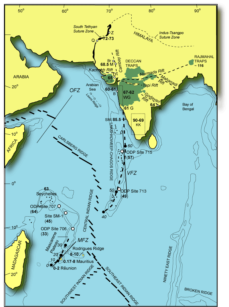
130 to 125 million years ago, a continent, which at that time included the Indian subcontinent, today's island of Madagascar and the islands of the Seychelles, separated from Antarctica and Australia , which were then part of the supercontinent Gondwana . 90 million years ago Madagascar also separated from the Indian plate, while the remaining part began to migrate northwards at the geologically high speed of up to 20 cm / year. Some scientists assume that the reason for this exceptionally high speed is that the lithosphere of the Indian plate is only about half as thick at 100 km as the lithosphere of the other fragments of Gondwana. About 65 million years ago, the islands of the Seychelles also separated from the Indian plate, with the new seam being called the Carlsberg Ridge today.
About 65 million years ago the Indian plate ran over a hot spot. Witnesses of this event are the Dekkan Trapps in what is now western India. This basalt layer , which is over 2000 m thick in some places and forms the Indian landscape of the Deccan , today extends over an area of more than 500,000 square kilometers. After passing through the Indian subcontinent, the hot spot caused the formation of the Chagos-Laccadive ridge and is now in the area of the volcanic island of Réunion , below the African plate.
The collision of the Indian subcontinent with Asia began 40 million years ago. Since then, the continental crust of the Indian plate is pushed under the Eurasian plate ( thrust ). Furthermore, the Eurasian plate is being thickened, so that the earth's crust below the Himalayas and the highlands of Tibet is now 60 km thick. The world average of the thickness of the earth's crust is 35 km. The subcontinent is still pushing 5 cm and more a year to the northeast into Asia, whereby the rising mountains are at the same time eroded and shaped by erosion . The average height of the Himalayas and the highlands of Tibet is just under 5 km, although individual mountains in the Himalayas protrude well above the average height. In the past million years, large amounts of rock have been transported from the mountains. Calculations show that around 8.5 million cubic kilometers of rock were deposited off the Himalayas and in the Ganges Delta .
earthquake

The advance of the Indian Plate against the Eurasian Plate creates tensions in the earth's crust, which not only lead to the unfolding of the Himalayas, the uplift of the Tibetan Plateau and the shifting of crustal material to the east, but also cause numerous strong earthquakes.
In 1934 an earthquake in the Kathmandu valley (Nepal) reached a magnitude of 8.3 on the Richter scale .
In December 2004 there was a seaquake in the Indian Ocean in the area between the Indian, Australian and Burma plates . The earthquake in the Burma plate had a magnitude of over 9.0 on the Richter scale with a hypocenter off the northwest coast of Sumatra ( 3 ° 19 ′ N , 95 ° 51 ′ E ). Several tidal waves caused devastating damage to coastal regions on the Bay of Bengal , the Andaman Sea , in large parts of South Asia and also on the coast of East Africa . It is estimated that the quake claimed approximately 230,000 lives.
The cause of this quake was a sudden shift in the earth's crust. The island of Simeuluë , which is closest to the epicenter, was moved about 15 meters in a south-westerly direction. Another consequence is the sinking of 15 smaller of the 572 islands of the Andaman and Nicobar Islands below sea level.
With the seaquake off Sumatra in March 2005, in addition to many smaller aftershocks, a large aftershock occurred in the region ( 2 ° 5 ′ N , 97 ° 1 ′ E ), which reached a magnitude of 8.7 on the Richter scale and around 1300 Claimed human life.
On October 8, 2005, the earthquake struck Kashmir near Muzaffarabad ( 34 ° 26 ′ N , 73 ° 32 ′ E ). Almost 85,000 people were killed, mainly in Pakistan, but also in India and numerous villages were destroyed.
The severe earthquake in Sichuan in 2008 was also due to the advance of the Indian plate against the Eurasian. The rock of the Tibetan highlands and its surroundings, compressed between the rigid interior of the Eurasian and Indian plates, gives way to the east and crosses the Sichuan basin . To the existing there fault occur also szonen repeatedly severe earthquake.
research
In 2011 it became known that there would be a microplate in the Tibetan plateau , the so-called Tibetan plate . Both the Eurasian plate and the Indian plate are said to slide under the newly discovered Tibetan plate, which moves northeast at a rate of five centimeters per year.
See also
Web links
- Maps with the location of the continents millions of years ago
- Amber finds from northwestern India are 50 million years old and reveal India's prehistoric world
literature
- Prakash Kumar et al .: The rapid drift of the Indian tectonic plate. In: Nature . Volume 449, 2007, pp. 894-897, doi: 10.1038 / nature06214
Individual evidence
- ↑ Laurence Lippsett: Geologists Find: An Earth Plate Is Breaking in Two ( en ) Columbia University, Office of Public Information. July 7, 1995. Retrieved May 14, 2008.
- ↑ GeoForschungsZentrum Potsdam: The fastest continent - India especially fast because of the halved lithospheric root . October 17, 2007. Retrieved April 27, 2015.
- ↑ Hetu C. Sheth: The Deccan beyond the plume hypothesis , map with the way of the Réunion hot-spot ( en ) August 29, 2006 (last update). Retrieved May 14, 2008.
- ↑ Archive version. Archived from the original on February 8, 2009 ; accessed on May 1, 2015 . Department of Geology and Geophysics: Underneath the mountains ( en ) Archived from the original on February 8, 2009. Retrieved May 14, 2008.
- ^ Rob Butler: Where and How Do the Continents Deform? ( en ) School of Earth Sciences, Leeds. October 2001. Retrieved May 14, 2008.
- ↑ Djordje Grujic: Geological Expedition in the Kingdom of Bhutan. Field observations and model presentations for the formation of the Himalayas - the interplay of erosion and climate . Geological Institute of the Albert Ludwig University of Freiburg. December 14, 1999. Retrieved May 14, 2008.
- ↑ H. Yao: Modeling crustal channel flow, crustal deformation and anisotropy with application to the Tibetan Plateau ( en ) Archived from the original on May 17, 2008. Info: The archive link was inserted automatically and has not yet been checked. Please check the original and archive link according to the instructions and then remove this notice. Retrieved May 14, 2008.
- ↑ scinexx.de: New tectonic plate discovered under Tibet, November 2011