Muzaffarabad
|
Muzaffarabad مظفر آباد |
||
| State : |
|
|
| Province : | Asad Kashmir | |
| Coordinates : |
34 ° 21 ′ N , 73 ° 28 ′ E
|
|
| Height : |
737 m
|
|
| Residents : | 96,000 (2010) | |
| Time zone : |
PST ( UTC + 5 )
|
|
|
|
||
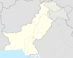
Muzaffarabad ( Urdu مظفر آباد) is the capital of the semi-autonomous region of Azad Kashmir and is located in the north of the state of Pakistan .
This area is not a province of Pakistan as it elects its own parliament. The population was estimated to be 96,000 in 2010.
Muzaffarabad is very close to the epicenter of the earthquake on October 8, 2005 . The quake had a magnitude of 7.6 on the Richter scale . It destroyed half of the houses in the city (including most of the official buildings). It is estimated that the earthquake killed 40,000 people in the entire region.
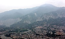
Muzaffarabad is located at the confluence of the Jhelam and Nilam rivers . The distance from Rawalpindi and Islamabad is 138 km, while Abbottabad is 76 km. In the midst of a mountainous backdrop, Muzaffarabad is a mixture of languages and cultures. Sights include the Red Fort, completed in 1646, at a bend in the Jhelam in the north of the city, and the Black Fort on a hill in the south from the Mughal era .
The current name of the city comes from Sultan Muzaffar Khan, a prince of the warlike Bomba clan from the middle of the 17th century.
Web links
- http://beforethequake.blogspot.com/ - pictures before the earthquake
- http://www.muzaffarabadonline.com/

