Rawalpindi
|
Rawalpindi راولپنڈی |
||
| State : |
|
|
| Province : | Punjab | |
| Coordinates : |
33 ° 36 ' N , 73 ° 2' E
|
|
| Height : | 500 m | |
| Area : | 108 km²
|
|
| Residents : | 2,098,231 (2017) | |
| Population density : | 19,428 inhabitants per km² | |
| Time zone : | PST ( UTC + 5 ) | |
| Telephone code : | (+92) 051 | |
| Postal code : | 46000
|
|
| Nazim ( Mayor ) : | Raja Javed Ikhlas | |
| Website : | ||
|
|
||
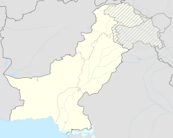
Rawalpindi ( Punjabi and Urdu راولپنڈی) Is a city on the Pothohar Plateau -Plateau in the province of Punjab in Pakistan . Until the completion of the seat of government in Islamabad , Rawalpindi was the provisional seat of the Pakistani government from 1958 until the 1960s. The industrial city has 2 million inhabitants. The headquarters of the Pakistani Army is located in the city . Even the Islamabad International Airport is actually in Rawalpindi and serves both cities.
history
The city was an important garrison town from 1851 and is still the seat of the Pakistani armed forces today. Urban planner Konstantinos A. Doxiadis also worked in Rawalpindi during the construction of the new capital, Islamabad . Today both cities have grown together.
Early history
Rawalpindi, also known as Pindi, has a history going back several millennia. Archaeologists assume that an independent culture lived on the plateau about three thousand years ago. The archaeological finds at the site of today's Rawalpindi prove that there was a Buddhist settlement here that existed at the same time as Taxila . The nearby city of Taxila has another meaning: According to the Guinness Book of Records, it is home to the oldest university in the world, Takshashila University.
Sir Alexander Cunningham identified ruins with the ancient city of Gajipur or Gajnipur, the capital of the Bhatti tribe in pre-Christian times. Graeco-Bactrian coins and old bricks are found in an area of approximately 5 square kilometers. The city known as Fatehpur Baori in ancient times was forgotten after the devastation caused by the " Huns " (more precisely by a group of the so-called Iranian Huns , see Alchon ).
The first Muslim invader, Mahmud of Ghazni (979-1030), handed the ruined city over to a Gakhar clan leader, Kai Gohar . However, the city, which was on a convenient route for invaders, failed to flourish during the Mongolian campaigns of the 14th century and remained devastated until Jhanda Khan, another gakhare, rebuilt the city in 1493 and named Rawalpindi after the village of Rawal. Rawalpindi remained under Gakharic rule until Muqarrab Khan, the last Gakhar ruler, was defeated by the Sikh under Sardar Milka Singh in 1765 . Singh invited traders from the neighboring trading centers of Jhelum and Shahpur to settle in the area. In the early 19th century, Rawalpindi was the refuge of Shodja Shah Durrani , the exiled King of Kabul , and his brother Shah Zaman for some time .
British rule
Following the UK's victory over the Sikhs and the occupation of Rawalpindi in 1849, the city became a permanent garrison of the British Army in 1851 . In the 1880s a railway line was built to Rawalpindi, and on January 1, 1886, the first train ran the new route. The need for a rail link arose after Lord Dalhousie had made Rawalpindi the largest garrison in British India .
With the establishment of British rule, Rawalpindi became a shelter for soldiers and shortly thereafter became the headquarters of a division. The connection with Peshawar through an expansion of the railway network brought both an immense expansion of the city and an increase in economic importance and prosperity. The city administration was established in 1867. The military camp contained a battery of horses, field artillery and mountain troops, a company of garrison artillery, a regiment of British and one of the native cavalry , two regiments of British and two native infantry , and two companies of engineers and miners . An arsenal was also built here in 1883 .
After independence
In 1951 the first elected Prime Minister of Pakistan, Liaquat Ali Khan, was assassinated in Rawalpindi . On December 27, 2007, the former Prime Minister Benazir Bhutto was murdered at the same location after her father Zulfikar Ali Bhutto , another former Prime Minister, was hanged in Rawalpindi in 1979.
The famous Murree Road was the scene of various political and social events. The Nala Lai , known for its floods, runs through the center of the city, separating it into urban and military areas. Historically, the purity of its water has been described as high enough for drinking water, but today it is contaminated with debris from all kinds of sources such as factories and private homes.
Climate and inhabitants
The literacy rate is 70.5% (as of January 2006). The population is ethnically and linguistically heterogeneous, with Pothoharis , Punjabis , Muhajirs and Pashtuns .
The weather is difficult to predict. The average annual rainfall is 910 millimeters. In summer the maximum temperature reaches up to 52 ° C, while in winter it can drop to -5 ° C.
Population development
| Census year | population |
|---|---|
| 1972 | 614,809 |
| 1981 | 794.843 |
| 1998 | 1,406,214 |
| 2017 | 2,098,231 |
For 2050, a population of over 5.1 million is expected in the agglomeration.
Attractions
Despite rapidly developing into a large city, Rawalpindi has many good hotels, restaurants, clubs, museums, and parks, of which Ayub National Park is the largest. Rawalpindi is the starting point for tourists who visit the holiday resorts in the Galyat region, such as Murree , Nathia Gali , Ayubia , Abbottabad , Swat , Kaghan , Gilgit , Hunza , Skardu or Chitral .
The city has two main streets: The Grand Trunk Road runs roughly in an east-west direction and is also known as the Mall. The Murree Road runs from the Mall of the north and crosses the railway tracks before it touches the eastern tip of the Old Town and Islamabad weiterverläuft. The two main bazaars are the Raja Bazaar in the old town and the Saddar Bazaar , which developed between the old town and Grand Trunk Road as the bazaar of the military district.
The crowded avenues of the old town are home to many attractions, including Hindu and Sikh temples, as well as Muslim shrines .
Thanks to its history, Rawalpindi is also home to the Pakistani Army Museum, where information about armies from colonial and modern times, arsenals and war heroes is presented.
Ayub National Park is beyond the old presidential residence on Jhelum Road . It occupies an area of about 9.3 km² and has a playground for children, a lake with boats, an aquarium and a garden restaurant. The Rawalpindi Public Park, which opened in 1991, is located on Murree Road . Here you will find play areas for children, lawns, fountains and flower beds.
The Rawalpindi cricket stadium, built in 1992, has a grass pitch, floodlights and a capacity of 15,000 spectators. The local team is called the Rawalpindi Cricket Association . The Rawalpindi hockey stadium also holds around 10,000 spectators.
Fort Rawat is 17 kilometers east of Rawalpindi, on the Grand Trunk Road towards Lahore . It was built in the early 16th century by the Gakhars, a proud and independent tribe of the Pothohar Plateau. Inside the structure is the tomb of a Gakhar leader named Sultan Sarang Khan. He died in 1546 fighting against Sher Khan Suri's armed forces . If you dare to step on the broken steps in the tomb, you get a great panoramic view over the plateau with the Mankiala stupa . About an hour from Rawalpindi is the Attock Fort on the same road in the direction of Peschawar . The former fortress is easy to see and is close to the Hazrat Jee Sahib shrine , the traditional burial place of the Bati family of the Paracha clan from the nearby (abandoned) village of Malahi Tola .
The Pharwala Fort is about 40 kilometers from Rawalpindi across the Lehtrar road . It is another Gakharic fort that was built in the 15th century on the ruins of the Shahi fort which was a Hindu site from the 10th century. General Babur conquered the fort in 1519. Later, in 1825, the Sikh drove the defeated Gakhars out of the fortress. Although the building is in a crumbling state, it is still an attraction for castle enthusiasts, even though it is only accessible to Pakistani visitors because of its location in the military zone.
Personalities
- Balraj Sahni (1913–1973), Indian film actor and author
- Muniruddin Ahmed (1934–2019), Pakistani Islamic scholar and writer
- Robbie Brightwell (born 1939), British athlete
- Sheikh Rasheed Ahmad (* 1950), Pakistani politician
- Asad Umar (* 1961), Pakistani politician
- Hanif Abbasi (* 1966), Pakistani businessman and politician
- Shoaib Akhtar (* 1975), Pakistani cricketer
transport
Airport
The Islamabad International Airport is actually in Rawalpindi and is served by more than 25 airlines, both national and international. The Pakistan International Airlines (PIA), the main Pakistani airline that flies daily to multiple destinations at home and abroad. The new international airport of Rawalpindi / Islamabad is being built near the city of Fateh Jang , about 25 kilometers away from the larger cities. In 2008 the airport was renamed "Benazir Bhutto International".
Street
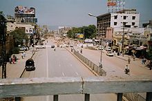
The main street through Rawalpindi is Murree Road , which is one of the busiest streets in Punjab.
Rawalpindi is also on the old Grand Trunk Road, or N-5, which connects Rawalpindi to almost all of the major cities in northern Pakistan, from Lahore to Peshawar .
The city is also served by two nearby six-lane highways, the M2 from Lahore to Islamabad and the M1 from Islamabad to Peshawar, which were completed in the 1990s. A little further away is the famous Karakoram Highway , which is the highest international road and connects Pakistan with China.
Public transport
The public transport in Rawalpindi is very complex, the spectrum ranges from yellow taxis, auto-rickshaws and minibuses to horse-drawn Tongas. Due to a lack of road planning, the traffic flows chaotically even on smaller roads. Buses with or without air conditioning are available for inter-city traffic and serve numerous destinations in Pakistan.
There is also a central train station in the Islamabad / Rawalpindi metropolitan area that allows travel to any major city in Pakistan.
religion
Rawalpindi is the seat of the Roman Catholic Diocese of Islamabad-Rawalpindi .
See also
Web links
Individual evidence
- ↑ Pakistan: Provinces and Major Cities - Population Statistics, Maps, Charts, Weather and Web Information. Retrieved July 25, 2018 .
- ↑ World 101 largest Cities. (PDF) Retrieved July 23, 2018 .


