Skardu
|
Skardu سکردو |
||
| State : |
|
|
| Province : | Gilgit-Baltistan | |
| Coordinates : |
35 ° 18 ′ N , 75 ° 37 ′ E
|
|
| Height : |
2316 m
|
|
| Residents : | 30,000 (2000) | |
| Time zone : |
PST ( UTC + 5 )
|
|
|
|
||

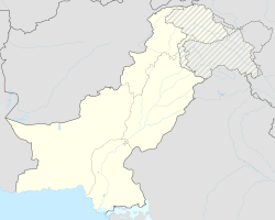
Skardu ( Urdu : سکردو) is the capital of the Pakistani region of Baltistan and the capital of the Skardu district , one of the districts that make up the Gilgit-Baltistan Special Territory (until 2009: Northern Territories) in Kashmir .
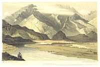
Skardu is located in the 10 km wide and 40 km long Skardu Valley , at the confluence of the Indus (which previously flows from the Kailash in Tibet through the neighboring Ladakh before reaching Baltistan) and the Shigar . Skardu is situated on a nearly 2500 m high plateau and is surrounded by gray-brown-colored mountains, the nearby eight thousand of the Karakorum hide.
Tourism, trekking and mountain expedition base
Skardu is, next to Gilgit , one of the two centers of tourism as well as for trekking and expeditions in Gilgit-Baltistan. The area's mountainous terrain, including the four eight-thousanders, attracts tourists, trekkers and mountaineers from all over the world. The main travel season extends from April to October, outside of this time the area can be cut off from the outside world for a longer period of time by the snowy, freezing winter weather.
Skardu, the nearby Askole and the Hushe Valley are the main gates through which the access to the snow-capped eight-thousanders K2 , the Gasherbrum group and Broad Peak as well as to the huge glaciers Baltoro , Biafo and Trango take place. This fact helped Skardu to develop into the most important tourist and mountaineering base in the entire area, which has a comprehensive travel infrastructure including many shops and hotels. Skardu also has its own airport, Skardu Airport .
Trekks to the Deosai plateau (4100 m), which is the second highest in the world after the Changthang in Tibet , start or end in Skardu. In the local Balti language , Deosai is called "Byarsa", which means something like summer place . With an area of about 3000 square kilometers, the prairie extends to Ladakh and provides a habitat for snow leopards , ibex , Tibetan brown bears and wild horses .
City and residents
The city has developed along the main street that runs through it. On both sides of the street is the New Bazaar (Naya Bazaar) with hundreds of shops selling everything from trekking needs to local goods. Behind the Naya Bazaar is the district with the older Purana Bazaar , and if you follow the main road to the west, you get to the polo square and the Kazmi Bazaar next to it .
At first glance, Skardu appears to be a distant, dusty provincial town, but it is a colorful melting pot of different ethnicities and nationalities. The crowded streets are mostly populated by Balti Tibetans, which is also reflected in the names (i.e. Khache-drong, Khar-drong, Olding, Kushu-bagh, Pakora, Thsethang, Sher-thang, Nagholi-spang, etc.). Because of their large proportion, Skardu is sometimes called the Little Tibet of Pakistan.
However, there are many other ethnic groups in Skardu including Pashtuns , Panjabers , Hunzukuc and Uighurs . Various ethnic groups from all areas of Pakistan have emigrated to the area since the country was founded.
All of the above ethnic groups are Muslims , including the Balti-Tibetans who converted from Tibetan Buddhism to Islam in the 16th century . The Shiite Islam in Skardu has a large following.

Weather and climate
Due to its location in the mountains, Skardu has a temperate climate in summer; the intense heat typical of the Pakistani lowlands does not prevail here. The mountains also hold off most of the monsoons , so rainfall in summer is quite low. However, the mountains of the region bring long severe winters. During the main travel season from April to October, temperatures drop from daytime up to 27 ° C (April) to daily values not exceeding 8 ° C (October). In December and January, temperatures below −10 ° C are normal, with minimum values of −25 ° C being possible.
getting there
The normal road connection to Skardu runs through the Skardu Valley via a road that branches off from the Karakoram Highway . There are also four or five other road connections to Kashmir and Ladakh. There is also the possibility to reach Skardu with one of the daily scheduled flights between Islamabad and Skardu Airport . The high cost of air travel makes the road connection a preferred option by locals and tourists alike.
During the winter months, Skardu is sometimes cut off from the outside world for a few days to several weeks because the streets are covered by avalanches. Then the air connection is the only way to reach the city.

Fort Skardu
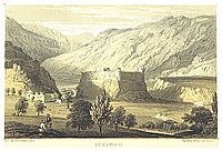
The Skardu Fort , Kharpochhe or Kharphocho (Tibetan: mkhar po che "Great Castle") called, lies on the eastern flank of Khardong Hill (Tibetan: mkhar gdong "castle") about 50 meters above the city. It was built around 1600 by Ali Sher Khan, the then ruler of the Makpon family of Skardu, and contains an old, largely ruined mosque. From the fort you can see the whole city and the surrounding valley. In the 19th century the fort was destroyed during the conquest of Baltistan by the Dogra from Jammu.
Skardu Road
Cricklewood's north-south connecting road takes its name from the fort of the same name.
Lakes in Skardu
There are three lakes near Skardu. In the Balti language, a lake is called thso or tso .
Kachura lakes
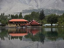
The Upper Kachura Lake and the Lower Kachura Lake , better known as Shangri-La Lake , are popular excursion destinations due to their idyllic location. The Chinese-style Shangrila Resort Skardu is located on the Lower Kachura Lake and is a famous destination for tourists.
Satpara Lake
Satpara Thso Lake or Sadpara Lake is the main lake of the Skardu Valley and an important source of water for the city. In 2002, the Pakistani government decided to divide the lake with a dam.
swell
- Karl Jettmar and others: Between Gandhara and the Silk Roads: Rock paintings on the Karakoram Highway: Discoveries of German-Pakistani expeditions 1979–1984. Philipp von Zabern, Mainz am Rhein 1985, ISBN 3-8053-0840-X .
- Karl Jettmar: Bolor & Dardistan. National Institute of Folk Heritage, Islamabad 1980, OCLC 15812986 .
Web links
- Blank topic The Northern Kashmir WebSite
- Skardu Pakistan
- Map of Skardu ( Memento of February 14, 2008 in the Internet Archive )
- The Changing Northern Areas. ( Memento of March 8, 2005 in the Internet Archive )
- WUnderground.com - Weather of Skardu
- Photos from Skardu, Kachura Lake and Satpara Lake by Waqas Usman
- Photos from Skardu and Kachura Lake by Arif Khan
- Photos from Skardu and Kachura Lake by Asher Yaqub Khan
- Historical information about Skardu
- Castles in Baltistan and Skardu


