Gilgit-Baltistan
| گلگت بلتستان Gilgit-Baltistan special territory
|
|
|---|---|
| Basic data | |
| Country | Pakistan |
| Capital | Gilgit |
| surface | 72,496 km² |
| Residents | 1,301,000 (2013) |
| density | 18 inhabitants per km² |
| ISO 3166-2 | PK-GB |
| Website | gilgitbaltistan.gov.pk |
Coordinates: 35 ° 30 ' N , 75 ° 30' E
Gilgit-Baltistan ( Urdu گلگت بلتستان, Gilgit-Baltistan ), until August 29, 2009 just north areas ( English Northern Areas , Urdu شمالی علاقہ جات, Šumālī 'ilāqajāt ) is a Pakistani special territory under federal administration in the far north of the country. It is not a province of Pakistan, but part of the disputed Kashmir region between China , India and Pakistan .
location
Gilgit-Baltistan borders the semi-autonomous region of Asad Kashmir , which belongs to Pakistan , the Pakistani province of Khyber Pakhtunkhwa , the Afghan province of Badachschan , the autonomous region of Xinjiang , which belongs to China, and the Indian Union territories of Ladakh and Jammu and Kashmir (clockwise, starting in the south) . The border with India is the Line of Control (LOC), which was established by the United Nations ( UNCIP / UNMOGIP ) in 1949 . It was fought over again in all Kashmir wars , most recently the Kargil War (Third Kashmir War ), a high-mountain war with many losses with combat zones up to 5000 meters above sea level, but in the 1999 armistice they reverted to the 1972 level. Since then there has been tension with individual incidents flaring up.
Districts, administrative division
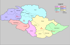
Gilgit-Baltistan is currently divided into ten districts, which are spread over two divisions.
On April 14, 2015, the then Pakistani Prime Minister Muhammad Nawaz Sharif declared the formation of four new districts in Gilgit-Baltistan: Hunza and Nagar (by splitting up from Hunza-Nagar ) and Kharmang and Shigar (by splitting off from Skardu ).
The following are the statistical data from Gilgit-Baltistan from 2013:
| division | District | Area in km² |
Pop. 1998 |
Inhab. 2013 † |
Administrative seat |
|---|---|---|---|---|---|
| Baltistan | Skardu | ||||
| Ghanche | 8,531 | 90,000 | 108,000 | Khaplu | |
| Skardu | 19,697 | 219,000 | 305,000 | Skardu | |
| Gilgit | Gilgit | ||||
| Astore | 5,411 | 72,000 | 114,000 | Gorikot | |
| Diamir | 7,234 | 135,000 | 214,000 | Chilas | |
| Ghizer | 12,381 | 121,000 | 190,000 | Gahkuch | |
| Gilgit | 4,208 | 148,000 | 222,000 | Gilgit | |
| Hunza-Nagar | 15,034 | 99,000 | 148,000 | Aliabad | |
| all in all | 72,496 | 884,000 | 1,301,000 | Gilgit | |
†: respected values
landscape
Gilgit-Baltistan is divided into the two divisions Gilgit in the northwest and Baltistan in the southeast.
The region belongs mainly to the Karakoram , with K2 (Godwin Austen, 8611 m ), Gasherbrum Group ( Hidden Peak : 8080 m , Broad Peak : 8051 m , Gasherbrum II : 8034 m ), Distaghil Sar ( 7885 m ), Masherbrum ( 7821 m ), Rakaposhi ( 7788 m ), the northwest to the Hindu Kush , highest peaks are Tirich Mir ( 7690 m ), Istor-o-Nal ( 7403 m ). The southern part is traversed by the upper reaches of the Indus , and the mountains south of it are already part of the Himalayas , with the Nanga Parbat ( 8125 m ) as the main peak. In total, 5 of the 14 eight-thousanders on earth are in the region within today's limits .
The area has the typical vegetation of the high mountains . The valleys are deeply cut. The Indus valley leaves the region at an altitude of 1000 m , at Jalipur, only 20 km from the eight-thousander Nanga Parbat, it is 1400 m , when entering the region near the Indian Kargil it is 2400 m . Other important valleys are that of the Gilgit , a tributary of the Indus from the Hindu Kush, and that of its tributary Hunza , which comes from the north of the Khunjerab Pass ( 4733 m ) on the border with China.
Population and traffic
The settlement is very thin. The only significant city is Gilgit on the Gilgit River . The main languages spoken are Urdu , Shina and Balti . The majority of the residents are Muslims , with the Shiites making up the majority, while Pakistan as a whole is more Sunni . In addition, Ismaili and Sufi traditions are strongly represented.
The Karakoram Highway runs through the northern regions, leading from Kashgar over the Khunjerab Pass, through the Hunza Valley, the lower Gilgit, the Indus Valley and on to Havelian between Islamabad and Peshawar .
Web links
Individual evidence
- ↑ “Cabinet approves 'Gilgit-Baltistan Empowerment and Self-Governance Order 2009'” 29 August 2009 Associated Press of Pakistan
- ^ Mountain TV: Govt. issues notifications for formation of Hunza, Nagar, Kharmang, Shigar districts in GB
- ↑ mountaintv.net: Nawaz Sharif announces formation of 4 new districts in GB
- ↑ gilgitbaltistan.gov.pk: Statistical Data (2013); PDF 7.5 MB ( Memento of the original from December 13, 2014 in the Internet Archive ) Info: The archive link was inserted automatically and has not yet been checked. Please check the original and archive link according to the instructions and then remove this notice.


