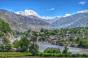
Tirich me
| Tirich me | ||
|---|---|---|
| height | 7708 m | |
| location | Khyber Pakhtunkhwa ( Pakistan ) | |
| Mountains | Hindu Kush | |
| Dominance | 238 km → Rakaposhi | |
| Notch height | 3910 m ↓ Broghol Pass | |
| Coordinates | 36 ° 15 '18 " N , 71 ° 50' 23" E | |
|
|
||
| First ascent | July 22, 1950 by Per Kvernberg | |
| particularities | highest mountain in the Hindu Kush | |
The Tirich Mir ( Urdu ترچ میر Tiritsch Mir ) is the highest mountain in the Hindu Kush with a height of 7708 m . Altitudes of 7690 m refer to the east summit .
location
The Tirich Mir is located north of the town of Chitral not far from the Afghan - Pakistani border, about 240 km northwest of Nanga Parbat and about 300 km from Kabul and Peschawar . Its ridges extend in all directions: north to Tirich Nord , east to the east summit, south to Three Glacier Peak and west to Khada Barma . Mighty glaciers lie between these ridges .
Ascent history
The first ascent was made by a Norwegian expedition in 1950. On July 22, 1950, Per Kvernberg was the first to reach the summit. The following day Arne Næss , Henry Berg and Tony Streather also reached the summit.
Web links
Commons : Tirich Mir - Collection of images, videos and audio files
- Tirich Mir, Pakistan on Peakbagger.com (English)
- Tirich Mir - Photos + Info (English)
Individual evidence
- ↑ List of the highest mountains (> 6750 m). In: 8000ers.com. Retrieved August 19, 2009 .
- ↑ Tirich Mir on Peakbagger.com (English)
- ↑ Tirich Mir East on Peakbagger.com (English)
- ^ A b c Arne Naess: Asia, Pakistan, The Norwegian Expedition to Trich Mir . American Alpine Journal, 1951, vol. 8th.

