Kunar
| کونړ Kunar
|
|
|---|---|
| Basic data | |
| Country | Afghanistan |
| Capital | Asadabad |
| surface | 4942 km² |
| Residents | 450,700 (2015) |
| density | 91 inhabitants per km² |
| ISO 3166-2 | AF-KNR |
| politics | |
| governor | Sayed Fazlullah Wahidi |
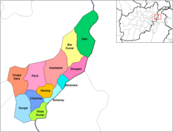
| Districts of Kunar Province (as of 2005) | |
Coordinates: 35 ° 0 ' N , 71 ° 0' E
Kunar (also Konar , Pashtun کونړ) is one of the 34 Afghan provinces and is located in the northeastern part of Afghanistan .
etymology
The word Kunar comes in historical texts as Kunar (کونړ), Kanir (کنیر), Kahwis (کهویس) and Kolo (کولو) and means "Valley of the Olives" in Nuristani languages . There used to be a lot of olive trees in Kunar, and olive trees are still planted today.
geography
Kunar has an area of about 4942 square kilometers. The province is located in the densely forested Hindu Kush Mountains.
Afghan provinces neighboring Kunar are Nuristan in the northwest, Laghman in the west and Nangarhar in the south.
To the east, Kunar is bordered by Pakistan , to the southeast by the Mohmand and Bajaur Agencies of the Pakistani tribal areas under federal administration and to the northeast by the Lower Dir and Chitral districts of the Pakistani province of Khyber Pakhtunkhwa . The border with Pakistan extends for 175 km along the Durand Line .
The provincial capital of Kunar is Asadabad .
topography
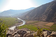
The Kunar River (also Kunar Rud ) rises in northwestern Pakistan from a glacier on the south side of the Hindu Kush and initially flows as the Chitral south to Afghanistan. On the Afghan side of the border, his name is then Kunar. The Kunar River flows into the Kabul River not far from Jalalabad .
The valley created by the river is called Chitraltal in Pakistan and Kunaral in Afghanistan.
The Afghan province of Kunar consists mainly of the section of the Kunar valley between the mountain highlands of the Nuristani in the north and the Kabul river valley in the south, as well as the Pech river valley , which flows into Asadabad , into which the Korangal valley located further south flows, and the other side valleys of the Kunar and the Bad luck. In the west there is no clear, natural and topographical demarcation from the other Afghan provinces in the Hindu Kush . The province is bounded in the east and southeast by the Kabul-Tsappar mountain range and in the northeast by the Kashmund mountain range .
About 86% of the province consists of mountains and dry high mountain slopes, which are criss-crossed by steep and densely forested river valleys. The valleys are usually difficult to access. The remaining 14% consists primarily of lowlands near the river.
population
Kunar has about 450,700 inhabitants, 95% of which are Pashtun and 5% are Nuristani .
About 11,000 residents of Kunar live in cities, mainly in the provincial capital Asadabad . The remaining 406,000 live in rural villages and on farms.
Kunar tribes
The Pashtuns of Kunars are divided into the tribes of Safi ( Gorbuz , Masud and Wadir ), Shinwari , Takari ( Salarzai , Wur and Kakazai ), and Mohmand , ( Baezai and Sepah ). In addition, Pashtun Kuchi (nomads) of the Ghilzai tribe also inhabit parts of the Kunar Province, especially in the summer in the area around Ghaziabad , but most of them migrate to the Afghan provinces of Logar , Wardak and Parwan in winter .
The Nuristani Kunars mainly belong to the Kom tribe. However, small groups of Nuristani of the Kalasha , Tregami , Kshto and Gramsana also live in isolated villages in the province.
language
Of the 771 places in the province, 705 mainly speak Pashto . The percentage of Pashto speakers in the total population is more than 90%. At 35 locations, is the main language Nuristani , in 15 locations Pashai and in two locations Dari and Uzbekist .
religion
The majority of the population of Kunar professes a Hanafi interpretation of Sunni Islam , the practice of which is heavily mixed with the pre-Islamic Pashtunwali code of honor .
In the province of Kunar there are 1,349 mosques and madrasas , many of which are assigned to a sect, which is shaped by the teaching of the fundamentalist Deobandis and represents a Pashtun-nationalist, radical interpretation of Islam: the so-called "students", i.e. Taliban .
education
There are around 115 schools in Kunar Province. Among them is probably the best-known high school in Khas Kunar , the “Dr. Kabir Stori Lycee ” . The only university in Kunar, Syed Jamaluddin Afghan University , has the best engineering degrees in Afghanistan alongside Dawat University in Kabul . About 27% of the population can read. It is around 8% of women.
health
There are three hospitals and 46 clinics and / or ambulance stations in Kunar Province.
economy
The majority of the population of Kunar live from animal husbandry and agriculture . In the Korangal valley in particular, logging is also practiced. In addition, the province of Kunar is a growing area for opium poppies , from which opium is obtained.
politics
The province's governor is Sayed Fazlullah Wahidi .
According to reports, Osama bin Laden is said to have stayed temporarily in this province bordering Pakistan.
Administrative division
Kunar Province consists of 16 districts, each headed by a district governor. The number, designation, and boundaries of districts are subject to frequent changes. Recently the districts of Asmar , Ghaziabad , Shigal and Watapur were newly formed from the area of other districts.
| District | Administrative seat |
Pop. | Area in km² |
notes |
|---|---|---|---|---|
| Asadabad | Asadabad | 29,177 | 680 | Asadabad is the capital of Kunar Province; the district also includes surrounding towns that are directly at the confluence of the Kunar and Pech rivers. |
| Asmar | Asmar | The Asmar district lies between the Asadabad section and the Dangam section, east and north of the Shigal district . | ||
| Bar Kunar | 20,716 | 651 | ||
| Chapa Dara | 28,681 | 489 | ||
| Dangam | 15,509 | 341 | ||
| Dara-I-bad luck | 44,958 | 528 | The Dara-I-Pech District is alternatively referred to as the Pech District or Manogai District. | |
| Ghaziabad | 23,663 | |||
| Khas Kunar | 31,950 | 325 | Khas Kunar is the largest district in Kunar and is adjacent to Nangarhar Province . | |
| Marawara | 17,316 | 174 | ||
| Narang | 27,937 | 212 | ||
| Nari | 32,510 | 681 | The district of Nari is alternatively called Naray . | |
| Nurgol | 25,047 | 368 | The district of Nurgol is alternatively called Nurgal . | |
| Sawkai | 28,905 | 262 | The Sawkai district is alternatively called Chawkay . | |
| Shigal | 33,781 | The Shigal district is in the Asadabad section, east and north of Wata Pur. It is alternatively referred to as the Sheltan District . | ||
| Sirkani | 24,080 | 231 | The Sirkani district is alternatively called Sirkanay . | |
| Watapur | 28,778 | The Watapur district is located in the western part of the Asadabad section. Alternatively called Wata Pur or Waterpor . |
Web links
Individual evidence
- ↑ Historical - and current Kunar. Professor Raziqi Naraiwal 2005 (in Pashtun: لرغونی او اوسنی کونړ)
- ↑ a b c d Kunar - Provincial Profile ( Memento of the original from October 7, 2010 in the Internet Archive ) Info: The archive link was inserted automatically and has not yet been checked. Please check the original and archive link according to the instructions and then remove this notice. . (English)
- ^ Afghanistan. In: citypopulation.de. Retrieved January 9, 2016 .
- ^ Program for Culture & Conflict Studies (Ed.): Kunar Executive Summary . ( wikimedia.org [PDF; 155 kB ; accessed on January 9, 2016]).
- ↑ a b Kunar Tribal Map at nps.edu (PDF; 217 kB)
- ↑ Dr. Kabir Stori Lycee in Khas Kunar (Pashtun) on April 7, 2013, accessed on April 13, 2014.
- ↑ Stori Mojala - issue of the magazine with the title page of the school
- ↑ ClassBase - Syed Jamaluddin Afghan University , accessed on June 1, 2014
- ^ Afghanistan Geographic & Thematic Layers


