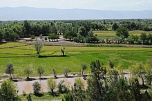
Tachar
|
تخار Tachar
|
|
|---|---|
| Basic data | |
| Country | Afghanistan |
| Capital | Taloqan |
| surface | 12,333 km² |
| Residents | 983,300 (2015) |
| density | 80 inhabitants per km² |
| ISO 3166-2 | AF-TAK |
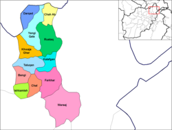
| Districts of Tachar Province (as of 2005) | |
Coordinates: 36 ° 42 ′ N , 69 ° 30 ′ E
Tachar ( Pashto / Persian تخار, DMG Taḫār ; in English translation Takhar ; also Toḫār ) is a province ( velayat ) in northern Afghanistan on the border with Tajikistan .
It has 983,300 inhabitants.
The name of the province is derived from the Tochars , who once ruled the region as the “ dynasty of the Kushana ” (see Yuezhi and Tocharistan ).
Administrative division
The province of Tachar is divided into 17 districts ( woluswali ):
Web links
Commons : Tachar Province - Collection of pictures, videos and audio files
- Side of the provincial (English)
Individual evidence
- ^ Afghanistan. In: citypopulation.de. Retrieved January 8, 2016 .


