Nangarhar
|
ننگرهار Nangarhar
|
|
|---|---|
| Basic data | |
| Country | Afghanistan |
| Capital | Jalalabad |
| surface | 7727 km² |
| Residents | 1,517,400 (2015) |
| density | 196 inhabitants per km² |
| ISO 3166-2 | AF-NAN |
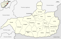
| Districts in Nangarhar Province (as of 2014) | |
Coordinates: 34 ° 15 ' N , 70 ° 30' E
Nangarhar ( Pashto ننګرهار; Dari :ننگرهار), also Nangerhar , is one of a total of 34 provinces in Afghanistan .
The province has an area of 7727 km² and has about 1.52 million inhabitants, most of whom are Pashtuns . It is located in the east of the country and borders Pakistan .
The provincial capital is Jalalabad . The main road from Kabul to Pakistan via the Khyber Pass runs through Nangarhar .
Administrative division
Nangarhar Province is divided into 22 districts ( woluswali ):
Web links
Commons : Nangarhar Province - Collection of pictures, videos and audio files
Individual evidence
- ^ Afghanistan. In: citypopulation.de. Retrieved January 8, 2016 .


