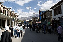
Kargil
| Kargil | ||
|---|---|---|
|
|
||
| State : |
|
|
| Union Territory : | Ladakh | |
| District : | Kargil | |
| Location : | 34 ° 33 ' N , 76 ° 8' E | |
| Height : | 2676 m | |
| Residents : | 16,338 (2011) | |
| View across the Suru River to Kargil | ||
Kargil ( Urdu کرگل Balti; Ladakhi ཀར་ གིལ ) is a city ( Municipal Committee ) in the Indian Union Territory of Ladakh .
Kargil is the administrative seat of the district of the same name . It is the second largest city in Ladakh after Leh .
In 2011 the population of Kargil was 16,338. 19% of the population are Hindus , 77% Muslim , 2.2% Sikhs .
geography
Kargil is located on the lower reaches of the Suru , at the confluence of the Wakha , 25 km above the confluence of the Suru in the Indus . The city lies at an altitude of 2676 m . The LOC runs 10 km north of the city. On the other side of this borderline is Gilgit-Baltistan ( Pakistan ). The city is 60 km from Dras and 204 km from Srinagar in the west, 234 km from Leh in the east, 240 km from Padum in the southeast and 1047 km from Delhi in the south.
climate
Like other areas in the Himalayas , Kargil has a temperate climate. The summers are hot with cool nights and the winters are long and cold with temperatures as low as −48 ° C. The average annual precipitation is 318 mm.
| Kargil | ||||||||||||||||||||||||||||||||||||||||||||||||
|---|---|---|---|---|---|---|---|---|---|---|---|---|---|---|---|---|---|---|---|---|---|---|---|---|---|---|---|---|---|---|---|---|---|---|---|---|---|---|---|---|---|---|---|---|---|---|---|---|
| Climate diagram | ||||||||||||||||||||||||||||||||||||||||||||||||
| ||||||||||||||||||||||||||||||||||||||||||||||||
traffic
The National Highway 1D , which connects Srinagar with Leh, runs through Kargil. Kargil has an airport .
A year-round road used to connect Kargil with Skardu , a town in Gilgit-Baltistan. The road has been closed since the First Indo-Pakistani War of 1948. The Indian government wants to open the road as a humanitarian gesture, the Pakistani government refuses.
history
Today's Kargil is not the capital of the historical Purig region in which it is located. Purig consisted of a number of independent kingdoms such as Chiktan , Phokhar , Sodh and the Suru Valley. These small empires often went to war with one another. Gasho "Thatha Khan" an expelled prince was probably the first ruler to unite the divided states in the 9th century. Another Sultan of Purig expanded the empire to include Zanskar , Pashkum and Sodh, which roughly corresponds to today's Kargil district. He is known as the Purig Sultan . Its capital was Karpokhar in the Suru Valley. It is said that the time of Ali Sher Khan Anchan , a Skardu prince, had a major impact on the region in the late 16th and early 17th centuries. This ruler from Baltistan conquered most of Purig's principalities and introduced the Balti culture. After that, Baltistan, Purig, Zanskar and what is now the Leh district were managed as one administrative unit from the first half of the 19th century until 1947 when the LOC Skardu separated from Kargil.
Before the partition of India in 1947, Kargil was part of the Baltistan district of Ladakh , a sparsely populated region with different language groups, different ethnic groups and religions in largely cut off valleys in the highest mountains in the world. The First Indo-Pakistani War (1947-1948) ended with the LOC, which separated the Baltistan district and where Kargil was on the Indian side in the Ladakh division of the Indian state of Jammu and Kashmir . At the end of the Third Indo-Pakistani War in 1971, the two states signed the Shimla Agreement in which they stipulated no more military conflicts over the border.
In 1999 Pakistani forces invaded the area but were repulsed by India in the Kargil War . The fighting area was a 160 km long strip of mountain ridges above the only road from Srinagar to Leh. The military posts on these mountain ridges are at an altitude of 5000 m and in some places also at 5485 m.
literature
- Osada et al. (2000). Mapping the Tibetan World. Yukiyasu Osada, Gavin Allwright, Atsushi Kanamaru. Reprint: 2004. Kotan Publishing, Tokyo. ISBN 0-9701716-0-9 .
Web links
Individual evidence
- ↑ census2011.co.in
- ↑ Osada et al. (2000), p. 298.
- ↑ a b census2011.co.in
- ^ Climate & Soil conditions . In: Official website of Kargil District . Archived from the original on April 16, 2009. Retrieved May 20, 2009.
- ^ Moving on the Kargil-Skardu road . Indian Express. April 24, 2007. Retrieved April 22, 2013.
- ^ The Kargil-Skardu Route: Implications of its Opening by Zainab Akhter . Ipcs.org. Retrieved April 22, 2013.
- ^ Q. 368 Present status of Kargil to Skardu Road | Institute for Defense Studies and Analyzes . Idsa.in. March 29, 2012. Retrieved April 22, 2013.
- ↑ A peaceful Kargil ( English ) Archived from the original on July 11, 2013.
- ↑ Javed Hussain: Kargil: what might have happened By Javed Hussain ( English ) In: Dawn . October 21, 2006. Archived from the original on September 27, 2007. Retrieved on May 20, 2009.
- ↑ Pervaiz Iqbal Cheema: The Armed Forces of Pakistan . Allen & Unwin, 2003, ISBN 1-86508-119-1 .
- ↑ 1999 Kargil Conflict ( English ) In: GlobalSecurity.org . Retrieved May 20, 2009.
- ↑ War in Kargil - The CCC's summary on the war ( English , PDF) Archived from the original on February 21, 2004. Retrieved on May 20, 2009.


