Padum
| Padum | ||
|---|---|---|
|
|
||
| State : |
|
|
| Union Territory : | Ladakh | |
| District : | Kargil | |
| Location : | 33 ° 28 ' N , 76 ° 53' E | |
| Height : | 3557 m | |
| Area : | 3.42 km² | |
| Residents : | 1,538 (2009) | |
| Population density : | 450 inhabitants / km² | |
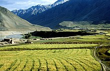
Padum (also Padam ) is the largest city and the administrative center of the district Kargil associated Tehsil Zanskar in the Indian union territory of Ladakh . Padum is about 240 km away from Kargil .
description
The population is around 1000. The traditional town center is below the gompa , where two large chortens stand above large buildings. In 1980 a road was built from Kargil over the Pensi La to Padum. The place has several hotels and restaurants for tourists. There is a post office, internet cafes and telephone booths.
geography
Padum is located in the center of Zanskar and has an average altitude of 3557 m . Several small villages are located around Padum.
climate
The winters are more rainy than the summers. The average annual rainfall is 366 mm. The warmest month is July with an average temperature of 15.4 ° C. In January the average temperature is only –9.2 ° C.
| Padum | ||||||||||||||||||||||||||||||||||||||||||||||||
|---|---|---|---|---|---|---|---|---|---|---|---|---|---|---|---|---|---|---|---|---|---|---|---|---|---|---|---|---|---|---|---|---|---|---|---|---|---|---|---|---|---|---|---|---|---|---|---|---|
| Climate diagram | ||||||||||||||||||||||||||||||||||||||||||||||||
| ||||||||||||||||||||||||||||||||||||||||||||||||
population
Padum is mainly inhabited by people of Tibetan origin, whose religion is Tibetan Buddhism . However, there is a significant Muslim minority (around 40% of the population), mainly Balti , who have lived in Padum since the 17th century. A mosque was built a few years ago. In 1996 already 70% of the population of Padum were Muslims.
Padum Valley
The Padum Valley is traversed by the Stod ( Doda ) and Lungnak rivers. Below Padum, the two rivers join to form the Zanskar River .
Some Buddhist monasteries are close to Padum, including Bardan and Kursha .
![]() Map with all coordinates of the mentioned places: OSM | WikiMap
Map with all coordinates of the mentioned places: OSM | WikiMap
Trek Lamayuru - Padum - Darcha
Padum is the start of the 2nd section of the Lamayuru - Padum - Darcha trek from Padum to Darcha. From Padum there are bus and truck connections to Kargil ⊙ . The trek follows the Tsarap River to Purne, from Purne to Kargyak the Kardyak Chu, after the Shingo La it follows the Jankar Nala to Darcha. The trek runs from Padum via Bardang Monastery ⊙ , Mune Gompa ⊙ to Reru ⊙ . From Reru we continue to the camping site Pepula, Tsetang, Kyalbok ⊙ , Purne ⊙ , detour to Phuktal Monastery ⊙ , Jal (Yal) ⊙ , Kuru ⊙ , Tangze ⊙ , Table ⊙ , Kargyak ⊙ , Shingo La ⊙ , Ramjak-Camp, Chikka ⊙ , Darcha ⊙ . From Darcha there are bus and truck connections to Manali ⊙ .
Web links
Individual evidence
- ↑ Village Amenities, Excel table at www.censusindia.gov.in. Retrieved December 6, 2018.
- ↑ a b Osada et al. (2000), p. 298.
- ↑ a b Jutta Mattausch: Ladakh and Zanskar , Reise Know-How Verlag Peter Rump GmbH, 1996, ISBN 3-89416-176-0 , pp. 335, 337, 360, 361, 412 - 424


