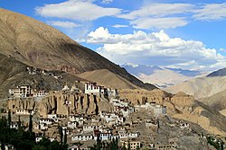
Lamayuru
| Lamayuru | ||
|---|---|---|
|
|
||
| State : |
|
|
| Union Territory : | Ladakh | |
| District : | Leh | |
| Location : | 34 ° 11 ′ N , 76 ° 0 ′ E | |
| Height : | 3573 m | |
| Residents : | 667 (2011) | |
Lamayuru or Lamayouro is a place in the Indian Union Territory of Ladakh .
The place is at an altitude of 3573 m in the Tehsil Khalatse of the Leh district . The place is the first place east of the Fotu-La pass .
The Lamayuru monastery is near the place.
According to the 2011 census, 667 people lived in Lamayuro. The literacy rate was 64.17%.
Web links
Commons : Lamayuru - collection of images, videos and audio files
- Blockwise Village Amenity Directory , Ladakh Autonomous Hill Development Council. Retrieved July 29, 2015
- Leh district census , 2011 Census of India Directorate of Census Operations. Retrieved July 29, 2015
climate
Lamayuru has a local steppe climate . The average annual rainfall in Lamayuru is 174 mm. The annual mean temperature is 3.2 ° C.
| Lamayuru | ||||||||||||||||||||||||||||||||||||||||||||||||
|---|---|---|---|---|---|---|---|---|---|---|---|---|---|---|---|---|---|---|---|---|---|---|---|---|---|---|---|---|---|---|---|---|---|---|---|---|---|---|---|---|---|---|---|---|---|---|---|---|
| Climate diagram | ||||||||||||||||||||||||||||||||||||||||||||||||
| ||||||||||||||||||||||||||||||||||||||||||||||||

