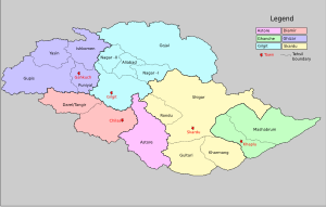
Ghizer (District)
|
Ghizer ضلع غذر |
|
| State : |
|
| Province : | Gilgit-Baltistan |
| Seat : | Gahkuch |
| Coordinates : | 36 ° 10 ′ N , 73 ° 45 ′ E |
| Area : | 12,381 km² |
| Residents : | 190,000 (2013) |
| Population density : | 15 inhabitants per km² |
| Time zone : | PST ( UTC + 5 ) |

|
|
Ghizer is the northwesternmost district of Gilgit-Baltistan , the territory in northern Pakistan that was designated as Northern Areas until September 2009 . Its capital is Gahkuch .
location
The Ghizer district covers an area of 12,381 km². The population was 121,000 in 1988. In 2013 it was estimated to be 190,000. The Ghizer district connects the cities of Gilgit and Chitral via the Shandur Pass . This district is a multi-ethnic district where three languages are spoken: Khowar , Shina and Burushaski . Furthermore, in parts of the village Ishkoman Wakhi is spoken.
Surname
The name Ghizer means refugees in the Khowar or Chitrali language . The Mehtars (kings) of Chitral forced the former residents of Chitral to emigrate and they settled in the area from Chitral to Gupis and were called Gherz or Gherzic. When Ali Bhutto , the former president of Pakistan, abolished the monarchical system and instead introduced administrative districts, this district was given the name Ghizer.
history
The area was formerly ruled by Indian Rajas (princes) from Yasin and Punial and was later divided between the Mehtars of Chitral and the Maharajas of Kashmir . After 1895 all Ghizers were incorporated into the Gilgit Agency and ruled directly by the British and no longer from Kashmir. The Rajas of Yasin, Suleman Shah and Gohar Aman extended their rule to Gilgit and some rulers exercised power from Yasin to Gilgit. After Gohar Aman's death there was a conspiracy by the Maharajah of Kashmir that reached as far as Yasin and Modori and ended in the Yasin debacle .
geography
The Ghizer district is located in the far north of the country of Gilgit-Baltistan. It stretches from the Wakhan strip of land in the northwest to the northern border of China . In the west the district borders on the province of Khyber Pakhtunkhwa , on the district Chitral and extends in the east to the city of Gilgit . The Diamir District is in the south of the district ghizer district, part of the Northern Areas of Pakistan.
The highest mountain in the Ghizer district is Koyo Zom with a height of 6871 m in Hinduraj , which lies on the border of the Ghizer district and Chitral. Other important places are in the Ishkoman and Yasin valleys , others are Gupis , Chatorkhand , Imit and Utz .
Gupis is an important part of the Ghizer district for tourist activities. There are several villages such as Phunder and Khalti, which offer trout fishing and accommodation in hotels.
Mountain passes
Since the area is a high mountain region, there are numerous mountain passes, the Karambar Pass , Chillinji Pass , Hayal Pass , Bichhar Pass , Darkot Pass and Naltar Pass on the border of the Ghizer and Gilgit districts . The Thoi Pass is near Yarkon on the border of Ghizer and Chitral.
Rivers
The largest river in the district is the Ghizer , also called the Gilgit . It flows in the east of the village of Gupis. Its tributaries are the Karambar (also Ishkoman ), Phakor , Hayal and Yasin .
Language areas
The language Burushaski is spoken in Yasin, Khowar is spoken in Yasin, Gupis and Ishkoman, Shina is spoken in Gupis and Punial, and Wakhi is spoken in Ishkoman.
Web links
Individual evidence
- ↑ a b c gilgitbaltistan.gov.pk: Statistical Data (2013); PDF 7.5 MB ( Memento of the original from December 13, 2014 in the Internet Archive ) Info: The archive link was inserted automatically and has not yet been checked. Please check the original and archive link according to the instructions and then remove this notice.
