Distaghil Sar
| Distaghil Sar | ||
|---|---|---|
| height | 7885 m | |
| location | Gilgit in Gilgit-Baltistan ( Pakistan ) | |
| Mountains | Hispar Muztagh ( Karakoram ) | |
| Dominance | 129.27 km → K2 | |
| Notch height | 2509 m ↓ Muztagh Pass ( 5376 m ) | |
| Coordinates | 36 ° 19 '33 " N , 75 ° 11' 18" E | |
|
|
||
| First ascent | June 9, 1960 by Diether Marchart and Günther Starker | |
| Normal way | glaciated alpine tour | |
| particularities | Hispar Muztagh's highest mountain | |
|
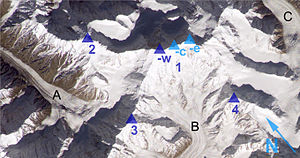
Distaghil Sar (1) captured by the ISS : west (-w), central (-c) and east peaks (-e) as well as the neighboring mountains Malangutti Sar (2), Bularung Sar (3) and Kunyang Chhish North (4) . |
||
The DISTAGHIL SAR (also DISTAGHIL SAR ) is a mountain in the Karakoram in the north of Pakistan in Gilgit-Baltistan .
location
It is the 19th highest mountain in the world, the seventh highest in Pakistan and the highest in Hispar Muztagh , one of the main chains of the Karakoram. Its summit ridge is over two kilometers long and, in addition to the 7,885 m high west summit, carries the 7,760 m high central summit and the 7,700 m high east summit.
Ascent history
In 1957 an English rope team failed when attempting to climb the mountain from the south and the west due to bad weather.
In 1959, bad weather also prevented an ascent by a Swiss expedition over the south-west ridge.
The first ascent of Distaghil Sar was achieved in 1960 by a five-person Austrian expedition led by Wolfgang Stefan. Günther Starker and Diether Marchart reached the summit on June 9th. The group climbed the western part of the southern flank and then walked over the southwest ridge to the summit.
The higher, western summit was climbed again using the original route in 1982.
Two attempts over the difficult north flank (1988 and 1998) were unsuccessful.
The first ascent of the eastern summit of Distaghil Sar was achieved in 1980 by a Polish expedition over the eastern flank. Since then it has only been ascended once, in 1983.
Web links
- Distaghil Sar on Peakbagger.com (English)
Individual evidence
- ↑ Asia, Pakistan, DISTAGHIL SAR . American Alpine Journal, 1961, vol. 12.
- ↑ www.Himalaya-info.org with Distaghil Sar
- ↑ Joaquim Prunes: Asia, Pakistan, DISTAGHIL SAR, Second Ascent . American Alpine Journal, 1983, vol. 25th
- ^ Józef Nyka: Asia, Pakistan, Disteghil Sar East and Yazghil Dome South . American Alpine Journal, 1981, vol. 23.

