Bularung Sar
| Bularung Sar | ||
|---|---|---|
| height | 7134 m (or 7110 m ) | |
| location | Gilgit-Baltistan ( Pakistan ) | |
| Mountains | Hispar Muztagh ( Karakoram ) | |
| Dominance | 4.29 km → Trivor | |
| Notch height | 514 m ↓ ( 6620 m ) | |
| Coordinates | 36 ° 18 '0 " N , 75 ° 7' 43" E | |
|
|
||
| First ascent | July 25, 1990 by a Swiss expedition | |
|
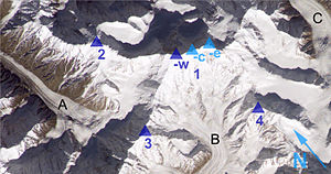
Distaghil Sar (1) captured by the ISS: west (-w), central (-c) and east peaks (-e) as well as the neighboring mountains Malangutti Sar (2), Bularung Sar (3) and Kunyang Chhish North (4) . |
||
The Bularung Sar is a 7134 m (according to other sources 7110 m ) high mountain in the Karakoram in Pakistan .
location
The Bularung Sar is located in a mountain range of the Hispar Muztagh between the western Trivor and the eastern Distaghil Sar . The Momhil Glacier flows on the north flank . The Kunyang Glacier runs on the southern slope .
Ascent history
The first ascent took place in July 1990 by a Swiss expedition over the south ridge. On July 25th, Thierry Bionda, Christian Meillard and Gérard Vouga reached the summit. Jacques Aymon, Vincent von Kaenel and Lothar Matter followed on July 27, and Heinz Hügli, Carole Milz and Jean-Jacques Sauvain on July 28.
Web links
- Bularung Sar on Peakbagger.com (English)
- Map with Bularung Sar at himalaya-info.org
Individual evidence
- ^ A b c Alain Vaucher: Asia, Pakistan, Bularung Sar, Hispar Mustagh . American Alpine Journal, 1991, vol. 33.
- ^ Bularung Sar First Ascent

