
Swat (district)
|
Swat District ضلع سوات |
|
| State : |
|
| Province : | Khyber Pakhtunkhwa |
| Seat : | Saidu Sharif |
| Coordinates : | 35 ° 23 ' N , 72 ° 11' E |
| Area : | 5 337 km² |
| Residents : | 2,161,000 (2014) |
| Population density : | 405 inhabitants per km² |
| Time zone : | PST ( UTC + 5 ) |

|
|
Swat District ( Pashto / Urdu سوات) is a district in the Pakistani province of Khyber Pakhtunkhwa . It is 5,337 km² and has a population of around 2.31 million. The capital of the Swat district is Saidu Sharif , but the largest city is the neighboring Mingora .
geography
The district is located in northwest Pakistan. In the east it borders on the districts of Kohistan and Shangla , in the south on the districts of Buner and Malakand , in the west on the Lower Dir and Chitral . In the north it borders on the Gilgit-Baltistan region , the former northern areas of Pakistan. The two largest cities are Barikot in the southwest and Mingora in the center of the Swat Valley.
economy
The district encloses the valley of the Swat river . The region is known as the "Switzerland of Pakistan" because of the lush green fields in the valley and the sparse coniferous forests that thrive on the hills of the middle altitudes.
history

The river that flows through the district and the name Swat was mentioned as Suvastu in the Hindu script Rigveda over 3000 years ago . Some of the petroglyphs ( Gogdara Rock Carvings ) found on the rock walls of the valley are probably around 3000 years old .
In the last centuries before Christian and in the first centuries after Christian the Swat valley was a center of Buddhism ; several stupas (e.g. in the villages of Amlukdara , Butkara or Shingardara ) and several rock reliefs with depictions of the meditating Buddha still indicate this today - one was partially destroyed by the Taliban fanatics.
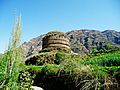
Amlukdara stupa

Shingardara stupa

Shingardara stupa


The Princely State of Swat existed in the region until 1969 .
The Taliban had taken control of the area from October 2007 to May 2009 and were engaged in ongoing skirmishes with government units. In May of the same year this led to a counter-offensive by the Pakistani army and large waves of refugees.
In August 2010, the Swat Valley was flooded during the flood disaster. The first case of cholera occurred there as a result of the ongoing flooding .
On October 2, 2012, the Taliban extremist Atta Ullah Khan shot the then 14-year-old Pakistani civil rights activist Malala Yousafzai in Mingora while she was sitting in a school bus with 13 other girls. The bus was brought to a halt by warning shots, and the hooded assassin shot four times directly into the bus from behind. Malala was hit in the head, another girl in the collarbone and another in the shoulder and hand. All three survived, Malala seriously injured. She received the Nobel Peace Prize in 2014 .
literature
- Fredrik Barth (Ed.): The Last Wali of Swat. An Autobiography as told to Fredrik Barth . Norwegian University Press / Universitetsforlaget, Oslo 1985, ISBN 82-00-07079-4
- Domenico Faccenna, Piero Spagnesi: Buddhist Architecture in the Swat Valley, Pakistan. Stupas, Viharas, a Dwelling Unit. Sang-e-Meel Publications, 2014, ISBN 978-969-35-2683-7
- Inam-ur-Rahim, Alain Viaro: Swat: An Afghan Society in Pakistan. Urbanization and Change in a Tribal Environment. City Press, Karachi 2002, ISBN 969-8380-55-8
Web links
- Swat Valley - Photos and information (English)
- Swat Valley - Photos and information (English)
- Buddhism in the Swat Valley - Photos and information (English)
- Buddhism in the Swat Valley - Photos and information (English)
- Report on the political and economic situation in June 2011 . rp-online.de
Individual evidence
- ^ "Pakistan troops seize radical cleric's base: officials" ( Memento from December 2, 2007 in the Internet Archive ), Agence France Presse, November 28, 2007, accessed on November 28, 2007
- ^ Journal of Indian History By University of Kerala Dept. of History, University of Allahabad Dept. of Modern Indian History, University of Travancore, University of Kerala Published by Dept. of Modern Indian History, 1963 page 28
- ↑ tagesschau.de ( Memento from May 14, 2009 in the Internet Archive )
- ↑ Swat Valley: Pakistan lets civilians flee
- ↑ First cholera case confirmed in Swat. Malteser , Aktion Deutschland Hilft , August 13, 2010, accessed on August 17, 2010 .
Abbottabad | Bajaur | Bannu | Batagram | Buner | Charsadda | Chitral | Dera Ismail Khan | Hangu | Haripur | Karak | Khyber | Kohat | Kolai Palas | Kurram | Lakki Marwat | Lower dir | Lower Kohistan | Malakand | Mansehra | Mardan | Mohmand | Northern Waziristan | Nowshera | Orakzai | Peshawar | Shangla | South Waziristan | Swabi | Swat | Tank | Torghar | Upper Dir | Upper Kohistan