Swat (river)
|
Swat دریائے سوات |
||
|
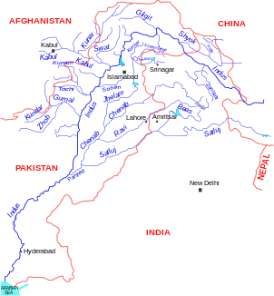
Location of the Swat in the river system of the Indus |
||
| Data | ||
| location | Federally Administered Tribal Areas , Khyber Pakhtunkhwa ( Pakistan ) | |
| River system | Indus | |
| Drain over | Kabul → Indus → Indian Ocean | |
| Confluence of |
Ushu and Utrar in Hinduraj 35 ° 28 ′ 47 " N , 72 ° 35 ′ 36" E |
|
| muzzle | at Charsadda in the Kabul coordinates: 34 ° 6 ′ 33 ″ N , 71 ° 42 ′ 22 ″ E 34 ° 6 ′ 33 ″ N , 71 ° 42 ′ 22 ″ E
|
|
| length | approx. 240 km | |
| Left tributaries | Chokel Khwar | |
| Right tributaries | Daral Khwar , Barwai Khwar , Harnol Khwar , Panjkora , Danish Kol Khwar | |
| Big cities | Mingora , Barikot , Charsadda | |
| Medium-sized cities | Bat Khela | |
| Small towns | Kalam , Madyan, Khwazakhela | |
| Communities | Bahrain | |
The Swat is a river ( Urdu : دریائے سوات , daryā-e Swāt ) in Pakistan that flows through the Swat Valley in the Pakistani province of Khyber Pakhtunkhwa .
course
The flow produced in the Hindu Raj at the location Kalam by the confluence of Gabral and Ushu and opens after passing through the districts Swat , Lower Dir and Malakand at Charsadda in from the west flowing Kabul , about 60 km above the mouth of the Indus .
Tributaries
The Swat has numerous smaller tributaries that have their source in the surrounding mountainous regions. The most important tributary is the Panjkora .
The river serves to irrigate much of the Swat district and contributes to the regional fishing industry. In the catchment area of the river, there are two larger plants for generating energy through hydropower , which supply the region with electricity .
history
The Swat is already mentioned in the Rigveda under the name Suvastu .
According to tradition, Alexander the Great crossed the Swat with parts of his army before turning south to subdue the inhabitants of the region.
While the area on the upper reaches of the river ( Kalam Valley) was late, i. H. was probably not settled until the 16th or 17th century, there are numerous archaeological sites on its lower reaches around the cities of Mingora and Barikot - including the Buddhist stupas and monasteries of Butkara , Amlukdara or Shingardara .
In the first decades of the 21st century, the Swat Valley came under the influence of the Taliban extremists at times.


