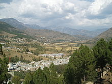
Batagram (District)
|
Batagram District ضلع بٹگرام |
|
| State : |
|
| Province : | Khyber Pakhtunkhwa |
| Founded : | July 1993 |
| Seat : | Batagram |
| Coordinates : | 34 ° 41 ' N , 73 ° 2' E |
| Area : | 1 301 km² |
| Residents : | 307,278 (1998) |
| Population density : | 236 inhabitants per km² |
| Time zone : | PST ( UTC + 5 ) |

|
|
The Batagram District ( Urdu ضلع بٹگرام, Pashtun ضلع بټګرام; engl. Spelling: Battagram ) is an administrative district in Pakistan in the province of Khyber Pakhtunkhwa . The seat of the district administration is the city of the same name Batagram .
location
The district is in the northeast of Khyber Pakhtunkhwa. It is bordered by Kohistan to the north, Mansehra to the east, the Kala Dhaka tribal area to the south and Shangla to the west .
geography
The district covers 1301 km². It extends over a mountainous country that forms the extreme west of the Himalayas . The mountains reach a height of over 4700 m in the district . There are also fertile flat areas in the valley in Nindhyar, Tijri Deshan, Batamori, Banna and Rashang. The Indus forms the western district boundary over a length of 35 km. The most important rivers in the district are Nindhyar Khawar and Allai Khawar .
climate
The climate in Batagram is characterized by moderately warm summers and very cold winters. In winter, large amounts of snow fall in the higher areas.
history
Batagram was originally a Tehsil in the Mansehra district. In July 1993 Batagram was given the status of an independent district. On October 8, 2005, a strong earthquake struck the area , in which 3564 people died and 3799 were injured in the district.
Languages and ethnic groups
The dominant language in Batagram is Pashtun . The largest ethnic group are the Swatis . The Gurjar , Akhunkhel, Madakhel, Syeds and Quresh tribes are also represented.
Administrative division
The district is divided into the Tehsils Battagram and Allai .
Web links
Individual evidence
- ↑ a b c d e f g h District Profile Battagram (PDF 810 KB) Earthquake Reconstruction and Rehabilitation Authority - ERRA. Retrieved March 22, 2017.
- ↑ a b c d District Courts Battagram . Retrieved March 22, 2017.
- ^ Batagram District Demographics . Government of Khyber Pakhtunkhwa. Retrieved March 22, 2017.

